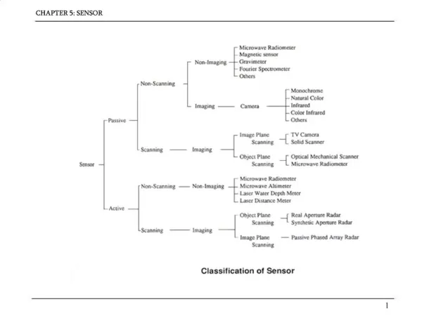
EG2234 Earth Observation
EG2234 Earth Observation. DISASTER Mitigation and relief. Topics. Introduction to applications Disaster management Fires Flooding Extreme weather Terrorism Tsunami Earthquakes Refugee monitoring. Uses of RS for Disaster Management. Wildfires Volcanic eruptions Avalanche Tsunami


EG2234 Earth Observation
E N D
Presentation Transcript
EG2234Earth Observation DISASTER Mitigation and relief
Topics • Introduction to applications • Disaster management • Fires • Flooding • Extreme weather • Terrorism • Tsunami • Earthquakes • Refugee monitoring
Uses of RS for Disaster Management • Wildfires Volcanic eruptions • Avalanche Tsunami • Earthquake Landslides • Flooding Extreme weather • Drought Disease • Refugees Military
Uses of RS for Disaster Management PLANNING Disaster Management LEARNING MITIGATION
Uses of RS for Disaster Management PLANNING MITIGATION Monitoring situations Deployment of resources Decision-making Public relations Modelling Assessment Prediction Contingency COST EFFECTIVENESS !!!
ERS • European Remote Sensing Satellite • all weather 25-500 metre land and sea observations, radar and Synthetic Aperture Radar • 3 dimensional mapping, oil spill detection, flood extent, damage assessment, night coverage
JERS • Japanese Earth Resources Satellite • all weather 18 metre land and sea observations • 3 dimensional mapping, oil spill detection, flood extent, damage assessment, night coverage
QuickBird • Launched in 1998 • visual 1 metre land observations • high-resolution mapping, infrastructure identification, terrain analysis
Uses of RS for Disaster Management Fires Fire detection by satellite provides a highly efficient means of detecting and eradicating forest fires without large numbers of ground-based workers Thermal infrared imagery shows “hotspots” that may be distinguished from clouds of similar albedo
Uses of RS for Disaster Management Fires • A fire detection and management system should have the following aims: • A measure of the geographical limits of the fire-front • An estimate of fire intensity • Monitoring of burnt area to look for latent fires • Mapping of burnt areas to aid restoration • (Barducci et al. 2002)
S.E Australian Fires February 2009 NASA Earth Observatory http://earthobservatory.nasa.gov/NaturalHazards/
S.E Australian Fires (10th February 2009) NASA Earth Observatory http://earthobservatory.nasa.gov/NaturalHazards/ From the Advanced Land Imager on NASA’s Earth Observing-1 satellite
Thermal Infrared (TIR) analysis of scene showing hot anomalies
Uses of RS for Disaster Management Flooding Floods are easily seen from space - particularly over very large areas. Sometimes the view of the ground can be obscured by clouds - not a problem if the flooding was due to a large storm system GIS models allow us to estimate the risk of flooding before it happens. Monitoring by both NOAA and Meteosat helped disaster mitigation activities in Mozambique during 2001
Uses of RS for Disaster Management Flooding A combination of both optical and radar remote sensing can provide a model for estimating likelihood of floodplain inundation (Townsend and Walsh, 1998) Often, detailed hydrological models are as important as the remotely sensed data to estimate risk and undertake effective post-disaster management
Uses of RS for Disaster Management Extreme Weather Many natural disasters result from extreme weather events such as hurricanes, typhoons and cyclones. These meteorological phenomena are typically large-scale and can be seen from space. Satellites allow us to track these phenomena, determine the likelihood of them affecting human population and hence undertake mitigation activities. The role of remote sensing for support of “geoengineering” activities for mitigation is discussed by Bauer et al. 1999
Uses of RS for Disaster Management Terrorism Following the assault on the World Trade Center in New York on september 11th in 2001, the Ikinos and NOAA satellites were used to obtain detailed images of the site affected. Lidar radar sweeps were used to “cut through” dust and build up a picture beneath RS data helped inform disaster management crews
Uses of RS for Disaster Management Tsunami Like coastal flooding, Tsunami events may be modelled and within a GIS. Complex computational fluid dynamics (CFD) requires very detailed bathymetric and topographic data retrieved from remote sensing missions. Earthquakes and landslides that contribute to tsunami formation can be assessed by different remote sensing techniques.
QuickBird used extensively throughout Asian Tsunami Disaster
QuickBird used extensively throughout Asian Tsunami Disaster
QuickBird used extensively throughout Asian Tsunami Disaster
QuickBird used extensively throughout Asian Tsunami Disaster
QuickBird used extensively throughout Asian Tsunami Disaster
QuickBird used extensively throughout Asian Tsunami Disaster
Uses of RS for Disaster Management Earthquakes The aftermath of an earthquake is clearly highly visible from space using high resolution satellites and aerial photography Detailed image analysis can assist ground crews to locations where electrical pylons, ruptured gas/oil pipes or urban fires require immediate attention. (See Wu et al. 2000)
Uses of RS for Disaster Management Refugee Monitoring In recent years, the advent of very high spatial resolution imagery has allowed disaster relief workers to monitor the movement of refugees both within a country (Mozambique for example) or between countries (Eastern Europe and Angola). Individual vehicles as well as groups of people can be tracked and their number assessed. This information can assist logistics to refugee camps or food aid distribution efforts. See: http://www.eurisy.asso.fr/events/humanitar/proceedings/ppt/WOLFF/
NEW Disaster Monitoring Constellation: http://www.dmcii.com/