Download
1 / 23
230 likes | 415 Vues
International Satellites – Supporting Global Earth Observation. ASPRS Meeting - 17 November 2011. Greg Stensaas Chair, CEOS Working Group on Calibration and Validation Remote Sensing Technologies Project Manager USGS Earth Resources Observation and Science (EROS) Center, Sioux Falls, SD.

E N D
International Satellites – Supporting Global Earth Observation ASPRS Meeting - 17 November 2011 Greg Stensaas Chair, CEOS Working Group on Calibration and Validation Remote Sensing Technologies Project Manager USGS Earth Resources Observation and Science (EROS) Center, Sioux Falls, SD
Many datasets, Many opportunities • > 100 EO satellites in orbit • Operated by > 34 countries, many with surface resolutions <1 m • Many expected to be launched in current decade • Common processes and procedures are lacking for defining quality
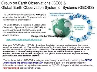
“Community” requirement The Group on Earth Observations (GEO) (founded 2002) is a voluntary partnership of 89 governments and 61 international organizations. GEO’s GEOSS must deliver comprehensive “knowledge / information products” worldwide and in a timely manner to meet the needs of its nine “societal benefit areas”. This will be achieved through the synergistic use and combination of data derived from a variety of sources (satellite, airborne and in-situ) through the coordinated resources and efforts of the GEO members. Achieving this vision (2015) requires the establishment of an operational framework to facilitate interoperability and harmonization. Climate Weather Strong Requirement Drivers
Committee on Earth Observation Satellites - http://www.ceos.org/ Troika (1-year terms) Chair Past Chair Future Chair Troika ASI/Italy ISRO/India CSA/Canada Permanent Secretariat CEOS Executive Officer (CEO) Strategic Implementation Team (SIT) Systems Engineering Office (SEO) Chair Agency ESA, EUMETSAT, JAXA, NASA, NOAA USGS (CEO) & NOAA (DCEO) Chair: NASAVice Chair: CNES (2-year terms) NASA Virtual Constellations for GEO WGClimate WGCV WGISS WGCBDD CEOS SBA Coordinators Chair EC-JRC Vice Chair NOAA Atmospheric Composition - NASA - ESA Precipitation - JAXA - NASA Land Imaging - USGS - ISRO - INPE Ocean Surface Topography - NOAA - EUMETSAT Ocean Color Radiometry - EC-JRC - JAXA - NASA Ocean Surface Vector Wind - NOAA - ISRO - EUMETSAT Sea Surface Temperature - ESA - NOAA Chair USGS Vice Chair CSA Chair JAXA Vice Chair TBD Chair INPE Vice Chair NOAA - Agriculture - Biodiversity - Climate - Disasters - Ecosystems - Energy - Health - Water - Weather WGCV=Working Group on Calibration and Validation WGISS=Working Group on Information Systems and Services WGEdu=Working Group on Capacity Building and Data Democracy WGClimate = Working Group on Climate
Current and Future EO Satellites • 112 different CEOS Earth observation satellite missions are estimated to be currently operating (November 2011). Many of these comprise series of missions planned to provide the continuity which is essential for many observations and applications. • Current plans supplied by CEOS agencies estimate that in the order of 100 new satellite missions will be launched for operation between 2011 and 2016. The next few years will mark a significant era for satellite Earth observations, with half of these new missions to be launched by the end of 2013.
Satellites • Military and Civil • Government and Commercial • EO satellites have many instruments and functions
ASPRS Land Imaging Satellites • Bill Stoney 2008 • http://www.asprs.org/Satellite-Information/Guide-to-Land-Imaging-Satellites.html
Use of multiple data sources • Partnerships and Integration of data • USDA (excellent example) • USGS (Landsat, SPOT, other) • NGA • ESA • … • Constellations • DMCii Surrey and partners • RapidEye • NOAA Operational Platforms • WHY • Science requirements • Repeat coverage and frequency needs • Validation sources • Integration of data to meet product needs
We need to understand the error • All systems and models have some degree of error • Calibration compensates for errors and improved measurement accuracy is possible • Bias between sensors need to be defined and there is a strong need for better error characterization • Data record error is essential for use in climate and change assessment • Different groups can produce defensible, but statistically inconsistent estimates of trends • Need a consistent playing field
Dome C Dome-C Cross Calibration Campaign • With so much impact and benefit to the cross calibration of sensors • 2Nd large CEOS field campaign is happening in now in December and January • Please contact CEOS WGCV IVOS subgroup ASAP • fox@npl.gov.uk • gchander@usgs.gov • Major opportunity to support and collect data for a detailed CEOS cross-comparison activity at Antarctica DOME C including a manned activity measuring surface BRDF.
Joint Agency Commercial Imagery Evaluation (JACIE) Workshop • April 17-19, 2012 • Fairfax, VA • Abstracts due • Search for JACIE on the web
JACIE intercomparisons and applications • Characterization and comparison results • VIIRS • Landsat • THEOS • ResourceSat-1/2 • GeoEye • Digital Globe • 8-band challenge • UK-2/Deimos -1 • New digital sensors and results • LiDAR • Sar • Application Assessment with new sensors
Future international data portal http://www.ceos.org/WGISS/ From CEOS WGISS: CEOS WGISS Integrated Catalog (QWIC) • Offers access to operational inventory systems at NOAA CLASS, NASA ECHO, USGS, INPE, and working on connection to AOE (China – NSMC, Beijing-1) • System of Systems proof of concept demonstrated • EuroGEOSS Broker (JRC) searching for INPE inventory data via CWIC • Demo of GENESI (ESA) searching for NASA inventory data via CWIC • Demo of CNES (JeoBrowser) searching for NASA inventory data via CWIC • NASA CWIC Data Portal will provide satellite data discovery and access through the IDN and CWIC • HMA and CWIC is discussing on future interoperability • Future data partner includes CCRS; future portal partners include Geo Web portal, CCRS agency portal, AC portal, LSI portal