Download
1 / 32
320 likes | 543 Vues
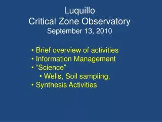
Luquillo Critical Zone Observatory September 13, 2010. Brief overview of activities Information Management “Science” Wells, Soil sampling, Synthesis Activities. How to “Critical Zone Processes” Vary with Bedrock Lithology ?.

E N D
Luquillo Critical Zone ObservatorySeptember 13, 2010 • Brief overview of activities • Information Management • “Science” • Wells, Soil sampling, • Synthesis Activities
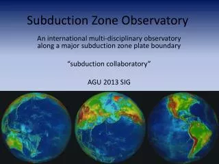
How to “Critical Zone Processes” Vary with Bedrock Lithology ? How critical zone processes, water balances, and mass fluxes differ in landscapes with contrasting lithology but similar climatic and environmental histories Granodiorite Volcaniclastic 7 General Hypothesis saprolite --- surface soils --- hillslopes/riparian zones --- transport & fluvial processes
Luquillo CZO Graniodiorite Coastal Plain Alluvium Hornfels Peaks Volcanoclastics Rainfall Runoff
Bedrock & Weathering Atmospheric inputs H2,H3 H1, H3 Tower Soils & Vegetation Hillslopes Catena’s H4,H5 Atmospheric Scholl, Shanley Mayol & UPR S. BalanUCB S Goldsmith Brown H3, H5 Sediment & solute Inputs to channel network Channel Network & Transport H5, H6 Fluvial & Coastal Depositional Environments
Bedrock & Weathering Atmospheric inputs Throughfall Silver & S. Hall Redox potential Riparian lysmeters Soils & Vegetation Hillslopes Catena’s ET and Water Balance W. Wu, IITF, F. Holwerda Sediment & solute Inputs to channel network Channel Network & Transport Fluvial & Coastal Depositional Environments
Bedrock & Weathering Atmospheric inputs Soils & Vegetation Hillslopes Catena’s Streams Tagged rocks 4 x-sections Conductivity Sediment & solute Inputs to channel network Channel Network & Transport Fluvial & Coastal Depositional Environments
Bedrock & Weathering Atmospheric inputs Soils & Vegetation Hillslopes Catena’s 2 Science Workshops Advisory Committee Larsen - USGS Lugo - USFS Bras Pavich Synthesis projects AGU session 2014 PR Sea Level Rise Thickness & boundaries Sediment & solute Inputs to channel network Channel Network & Transport Fluvial & Coastal Depositional Environments
Infrastructure Bisley road Field Station Weather Station Information Management 11-23 inches/day ~ 1 in/15 min
Information Management • Searchable Drupe Web page • Interface with SDSC • Project Descriptions & Data Sets • 20 project descriptions • 67 data sets
LCZO 20 Project Descriptions 67 Data Sets
LCZO Web site Usage;April 1 to Sept 6, 2010 315 Unique Visitors
“CZO Soil Dig” Students + Professor & Post Doc + rain & mud 180 Quantitative pits
Simplified from USGS Geologic Maps Contacts vs non-contacts
Vegetation & Climate & Elevation are covariates Sample; by forest type and elevation range within forest type
3 slope positions, 3 forest types 2 bedrocks; 3 elevations = 54 combinations; 3 replicates ~ 162-190
Soils and LIDAR C, N Base cations being processed… SOM/SOC modeling Soil P; Brown MS N & Cations…Upenn students
Bedrock to Soil….. surface surface soil Micro-porosity increases Weathering zone bedrock bedrock Channel Morphology H2O Chemistry (McDowell & Brantley) CR Observation Wells
3 Critical Zone Observation Wells 37 m, 27 m, 28 m deep
“young on outside old on inside” • Volcaniclastic • 25 m “red clay” • 28 m ~ competent, fractured • “Landslide” Weathering zone bedrock Granodiorite 28 m deep 20-28m fine crystalline
“young on outside old on inside” Volcaniclastic Next Year Stratigraphy & petrology Groundwater levels Water sampling Weathering zone bedrock Granodiorite
Holocene Sea Level “Rise” Coastal Morphology
Sediment Cores • Nicol Khan • UPenn PhD Thesis • C. Vane • British Geological Survey
Uplift and Denudation (estimates) Long-term Denudation Short-term uplift
Synthesis Activity Boundaries, volumes, rates of change of Critical Zones 600-900 m TWI • Critical Zones; • Depth and boundaries • Lithology • GD, VC, HF, Mafic • Fluxes & rates • By location, event • Morphology • Boulders….Peaks… • Stream channels… Veg. zone 20-30 m 1 m thick O horizon to 1m Saprolite 2-30 m Landscape Scale
Coming Attractions 2010/11 • Information management • QA/QC legacy data & “Synthesis” products • Soils • Lab analysis by 2011 • Projects on SOM, Ca, P,..Microbes… • Observation wells • Monthly water sampling, linking to surface water • Hydrology & Climate • Sampling campaigns, Flow paths vs Lithology • Collaborative Studies • M. Bruns & Alaya, A. Kurtz, S. Porter & S. Goldsmith, O. Mayol • Dating….
“Old on the inside young on the outside” Graniodiorite Coastal Plain Alluvium Hornfels Peaks Volcanoclastics Rainfall Runoff 4 Lithologies X 4 Forest Types How deep is the CZ?
Description Location Publication Data Sets
Next Year Basic C,N, Cations Geochem data format SOC/SOM modeling Brown Masters Thesis on Soil P UPenncapstones Ca, N Multivariate analysis
Deep Weathering Zone Granodiorite 28 m deep 20-20m fine crystalline • Volcaniclastic • 25 meter “red clay” • 28 m ~ competent, fractured rock
Uplift & Denudation Estimates, mm/yr Geochemical Denudation Studies Holocene Uplift Miocene Uplift
Bedrock to Soil….. surface surface soil Micro-porosity increases Weathering zone bedrock bedrock Stage 1. Formation of thick (~100 m) weathering zone Stage 2. Exposure to the surface by river incision