Download
1 / 70
710 likes | 957 Vues
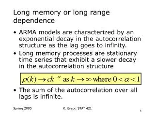
MLRA Long Range Plans. Objective - Upon completion of this training, the participant will be able to understand the purpose of a Long Range Plan and how the Long Range Plan is integrated into Management of Soil Survey by MLRA.

E N D
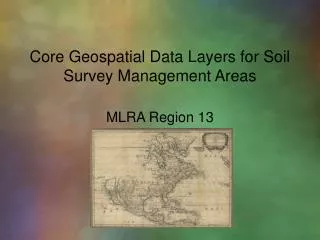
MLRA Long Range Plans Objective - Upon completion of this training, the participant will be able to understand the purpose of a Long Range Plan and how the Long Range Plan is integrated into Management of Soil Survey by MLRA
“Plans are only good intentions unless they immediately degenerate into hard work.”- Peter Drucker
Long Range Plans • Purpose & Context of the Long Range Plan • Teams associated with the Long Range Plan • Link between the Evaluation & the Long Range Plan • Content of the Long Range Plan • Publication of the Long Range Plan
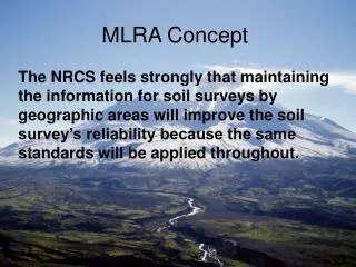
Long Range Plans (NSSH 610) A Long Range plan for the MLRA Soil Survey Area considers all aspects of bringing all soil surveys in the area to a common standard to meet user needs.
Long Range Plans (NSSH 610 - pending) • The document provides a framework for how the MLRA Soil Survey update should proceed. • Document should relate how the update will meet user needs and help stakeholders. • Stakeholders include the Board of Directors, Districts, Federal Agencies, NRCS planners etc.
Long Range Plans (NSSH 610) Lists major items to bring existing surveys to standard defined in MLRA Region MOU UNITED STATES DEPARTMENT OF AGRICULTURENATIONAL COOPERATIVE SOIL SURVEY MEMORANDUM OF UNDERSTANDING between the NATURAL RESOURCES CONSERVATION SERVICEand the ….RELATIVE TO THE MAKING AND MODERNIZATION OF ALL SOIL SURVEYS WITHIN MAJOR LAND RESOURCE AREA SOIL SURVEY REGION 4 - NORTHERN ROCKY MOUNTAIN REGION
Plans Required in MLRA Soil Survey Offices (NSSH 606) • Long Range Plan • Project Plan • APO
Long Range, Project, Annual Plans(NSSH 606) • Long Range Plan - all aspects of bringing the soil survey to a common standard • Project Plan - to accomplish a high priority within a defined timeframe • Annual Plan of Operations to identify objectives, responsibilities & timelines during a fiscal year
Long Range Plans – Teams (NSSH 608 & 610) • Technical Team – guidance related to resource needs and concerns • Management Team – support in development of plans and setting priorities • Board of Directors – approve the Long Range Plans
Long Range Plans – Technical Team (NSSH 610) • Primary evaluation team • Provide technical information and advice to the MLRA Soil Survey Leader • Membership includes the MLRA Soil Survey Leader, the respective Soil Data Quality Specialist, and Resource Soil Scientists • Members may include Range Specialists, District Conservationists and others that can provide knowledgeable technical information
Long Range Plans – Management Team (NSSH 610) • Identified needs for the MLRA Soil Survey Area are prioritized by the MLRA Soil Survey Area Management Team • Members include the State Soil Scientists served by the MLRA Soil Survey Office • Includes the NCSS Partner when Federal reimbursable projects are involved • Provide guidance and support to the MLRA Soil Survey Office
Long Range Plans – Board of Directors (NSSH 610) • Identified needs for the MLRA Soil Survey Area are reviewed by the Board of Directors • BOD includes State Conservationists from the States Serviced by the MLRA Regional Office • Provide guidance to the MLRA Regional Office and resolve issues raised by the Management Team
Link Between Long Range Plan & Evaluation (NSSH 610) • Develop Long Range Plan based on the general evaluation to identify soil mapping issues • Plans to update soil mapping depend on the results of the evaluation • Rely on the knowledge of the Technical Team to identify issues during the general evaluation
LRP – Evaluation Process • What information should be collected before developing the Long Range Plan?
Data to be Assembled 610 • map unit descriptions • unpublished soil information • records documenting soil survey joining problems • interpretations • correlation records • field review reports • special investigation and laboratory data • pedon descriptions • transect data • tacit knowledge of those experienced in the area • notes of needed changes recorded in the office copy of the published soil
Using GIS to identify survey area subsets within the MLRA Office Area MLRA 105 Crosses Into 35 Unique Non-MLRA Soil Survey Areas.
THE ORIGINAL SOIL SURVEY REPORTS WILL PROVIDE IMPORTANT INFORMATION
Some survey areas have two or three publications! What changed?
SOIL SURVEY REPORT • Map Unit Descriptions (Concept) • Composition • Dates of Field Work • Project Members • Georeferenced Series Descriptions (TUDS) • Dual Drainage Class? • 3SD Overrides? • Layer Thickness
Each MLRA Office should have copies of the correlation documents available in their area.
The Correlation Document Provides • Who (Who did the mapping) • When It Occurred • How many components (series and phases) • Notes to Accompany Series
The MLRA Explorer Snap Shot www.cei.psu.edu/mlra/
NASIS Reports MLRA Acres by Component MLRA Acres by Map unit
NASIS Reports Uses lmapunit and overlap tables
Technical Team Interviews • The evaluation for the Long Range Plan is heavily dependent on the Technical Team members. The team members should be interviewed to identify potential issues to be addressed in the LRP.
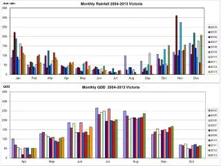
Historical Imagery 1939 • 1976 1985 2006
Multiple Year Imagery Sets Provide • Land Use Changes • Hydric Signatures • Flooding Signatures • Erosion? • Siltation? • Other?
What other types of data? • Farm and Ranch Plan Mapping • STATSGO • Geological Survey? • FEMA Maps? • Other?
Other Historical Resources • Maybe There’s a (Re)Tired Soil Scientist Around • University Cooperators • Masters Thesis or PhD Dissertations • What can the Field Office Staff Tell You? • Crop Consultants and Extension Agronomists • Foresters and Other Land Managers
Your GIS Workstation • Utilize digital layers of your MLRA • What Layers Are Available? • How Many SSA’s? • Distribution Maps
NCGC developed MLRA-SSO Geodatabases contain: • Detailed SSURGO Maps • 30m Digital Elevation Models • National Hydrography Layer • web map services NAIP (http://gis1.ftw.nrcs.usda.gov/arcgis/services)SSURGO (http://sdmdataaccess.nrcs.usda.gov/Spatial/SDM.wms?)
Distribution and Extent Maps Distribution map of fine-silty…typic hapludalfs in MLRA 105
Where is the Series Mapped? The Arenzville Series extends beyond MLRA 105. There is a gap in survey areas where Arenzville was not mapped.
Is there lab data available? Using Advanced Query by MLRA from Characterization web site Returns 265 pedons sampled in 105
Is there lab data available? Grab the NSSL access database by MO from lab sharepoint site
Long Range Plan - Content • Think of the Long Range Plan as an MLRA “Thunderbook” that lists: • All manuscripts and their publication dates • Soil Survey Areas and correlation dates • Unique map unit names and total acreages • Unique components and their OSDs • Component acreage by survey area and totals • Correlation reports for the survey areas • NSSL samples
MLRA Soil Surveys with Initial Soil Surveys (NSSH 607) • Long range plan specifies the deliverables & sets time period to complete the survey • Initial soil surveys are planned to complete a defined soil survey area • Initial survey is a subset of the MLRA Soil Survey Area and is managed within that larger physiographic context
Long Range Plans – Content • General nature of the survey area • General evaluation findings of existing soil surveys • Land Resource Units for Project Development • General supporting information • Update strategy of the survey area
Long Range Plan – Items to Include • General nature and setting of the MLRA • SSA Landownership in the MLRA SSA with status • Listing of initial soil surveys to be completed
Long Range Plan – Items to Include • Map & list of geographic subsets upon which project activities will be based. • Major findings from the evaluation documenting deficiencies and areas needing improvement and enhancement.
Long Range Plan – Items to Include • Provide a discussion of the strategy to achieve the needed updates
Long Range Plan – Items to Include • Next few slides are of a future NSSH exhibit of items to include in a Long Range Plan