Download
1 / 21
220 likes | 531 Vues
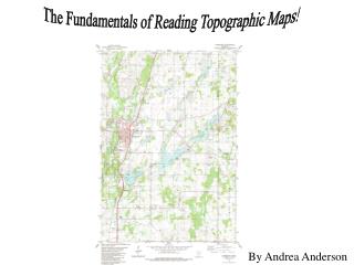
The Fundamentals of Reading Topographic Maps!. By Andrea Anderson. What will you Learn????. What is a Topographic Map? Longitude and Latitude Township and Range Contour Lines and Intervals How to Read a Topographic Map Topographic Map Symbols Topographic Map of Cambridge

E N D
The Fundamentals of Reading Topographic Maps! By Andrea Anderson
What will you Learn???? • What is a Topographic Map? • Longitude and Latitude • Township and Range • Contour Lines and Intervals • How to Read a Topographic Map • Topographic Map Symbols • Topographic Map of Cambridge • More about Topographic Maps • What did you Learn? • Links
1. What is a Topographic Map? Topography: 2. The science of drawing on maps and charts or otherwise representing the surface features of a region, including hills, valleys, rivers, lakes, canals, bridges, roads, cities, etc. – Webster’s New World Dictionary Topographic Map
2. Longitude and Latitude The grid on this globe is made up of parallels and meridians. The parallels are horizontal lines also called Latitude and the meridians are vertical lines called Longitude.Longitude and Latitude project a much easier way to find a location.
How to use Latitude and Longitude Longitude and Latitude lines are presented in degrees. 0° Latitude is the Equator, and 0° Longitude is the Prime Meridian. On the opposite sides of the Equator are North(N) and South(S). On the opposite sides of the Prime Meridian are East(E) and West(W). To find a location with Longitude and Latitude, use a Latitude line and a Longitude line, and find where the two lines meet. For example, this is 90° E, 30° N
3. Township and Range Besides Longitude and Latitude, there is Township and Range. Townships are 36 square miles each and each township is made of 36 sections, so each section is 1 square mile. You can use Township and Range just like longitude and Latitude, only to find sections. Range runs North and South, and Township runs East and West. These red letters represent range. This red number represents a section.
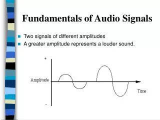
4. Contour Lines and Intervals The spaces between the lines are called Contour Intervals. The lines are called Contour Lines. Yes, but what do they mean??
5. How to Read a Topographic Map What do contour lines and intervals mean? Each contour line represents an increase or decrease in elevation. Elevation is the height of land above sea level. It is represented in feet. Here are some pictures to better understand contour lines and intervals…
5. How to Read a Topographic Map continued… Some rules of thumb: • The closer together that the contour lines are, the steeper the slope. The farther apart they are, the more gradual the slope. • Ridges and Rivers make a steep rise or decline in elevation, which give the contour lines “points”. At the bottom of the topographic map look for the contour interval, the height in elevation between the contour lines.
6. Topographic Map Symbols Circular contour lines with dashes represent a depression. Little black squares are buildings. Depression The black square with a cross is a church or house of worship. A box with a flag on top is a school.
Symbols Continued… -Art Museums/Science Centers -Beaches -Campgrounds -Parks
Comparing pictures… The town of Cambridge The stoplights on Main Street
You are Here Depressions
Anoka-Ramsey Community College Located at Township 36 N, Range 23 W in Section 32
8. More about Topographic Maps The green areas represent wooded areas, and the white is open area. This area with the blue is a marsh.
Abbreviations AFB………Air Force Base BDY………Boundary Bk…………Brook Br…………Branch Co…………County CONSTR…Construction Cr…………Creek Dr…………Drain Fk…………Fork FOR………Forest Hol……….Hollow Hgts………Heights IND RES…Indian Reservation Jct………..Junction L, Lk…….Lake MIL……..Military NAT…….National NF……….National Forest NP…….National Park Pt………Point R…….River REF……Refuge Res…….Reservoir RES……Reservation, Reserve SF……State Forest Sl…..Slough SP…..State Park Spr(s)….Spring(s) Sta……..Station SWMA…..State Wildlife Management Area TR…….Trail Vly…….Valley
9. What did You Learn? How do you use Longitude and Latitude? What is a Topographic Map? What is Longitude and Latitude? What is Township and Range? How many square miles is a Township? What is a Contour Line? What is a Contour Interval? What do Contour Lines and Intervals represent? What does it mean when Contour Lines are close together? Can you name 5 Topographic Map Symbols? What does green on a map represent? What does NF mean?
10. Links http://www.dugcaves.com/more/topokey.htm http://www.extension.org/pages/9695/topography-and-understanding-topographic-maps http://www.satsig.net/lat_long.htm