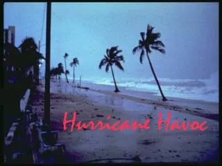
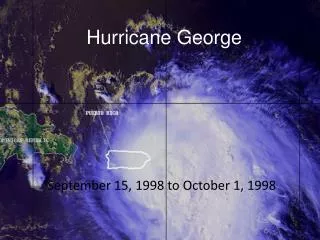
Hurricane George
Hurricane George . September 15, 1998 to October 1, 1998. George was the second deadliest and strongest hurricane within the Atlantic Basin during the 1998 season. This storm lasted 17 days with 7 landfalls, it pass through northeastern Caribbean and the coast of Mississippi.

Hurricane George
E N D
Presentation Transcript
Hurricane George September 15, 1998 to October 1, 1998
George was the second deadliest and strongest hurricane within the Atlantic Basin during the 1998 season. • This storm lasted 17 days with 7 landfalls, it pass through northeastern Caribbean and the coast of Mississippi. • Leaving 602 fatalities mostly in the Dominican Republic and Haiti.
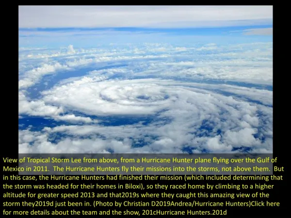
Georges Originates • As a tropical wave, which crossed the west coast of Africa by September, 13, 1998. 15, Sept 1998 (Tropical Depression) Forming about 300 miles SSW of Cape Verde Islands in the far Eastern Atlantic .
24 hours later the tropical depression continued to organized as a banding features developed and deep convection formed over the center of the storm. • The system became a tropical storm on September, 16, 1998. • This storm continued to move WNW for ten days, a classic Cape Verde type and strengthening with height. • It reach hurricane stage the 17 of September when the eye became visible in the satellite imagery. • When this was noticed the hurricane rapidly strengthen. • The 19 of September it was confirm to be category 4 hurricane. • Winds of 146 knots and a minimum pressure of 938 MB.
Forecast • The weather forecast for this storm was a good forecast. • The slow movement of the storm over the northern central Gulf of Mexico contributed to low errors. • Most of the tracks model guidance were really accurate just for the exception of BAMS, AVNI, AVNO and A98E.
This diagram shows how Hurricane George pass through Puerto Rico , Dominican Republic, Cuba, Key west and parts of the US.
Focus On Puerto Rico • Hurricane George was the worst hurricane to hit Puerto Rico since hurricane “San Ciprian” in 1932. • Hurricane George was a category 3 hurricane when it hit Puerto Rico. • This storm crossed the entire island from east to west. • Around 6:00 Pm this Hurricane made landfall in eastern Puerto Rico with winds of 100 knots.
Georges continued in a WNW direction over eastern Puerto Rico with a very impressive eastern eye wall showed in the San Juan Radar. http://www.srh.noaa.gov/sju/?n=1998_georges_loop • After passing the mountain range in PR the storm weaken back to category 2 by orographic effect. • Winds of 95 knots affected the west part of the island and the eye left the island at 1 am September, 22, 1998.
The path of Hurricane George Rincon September 22nd - 12:45 AM AST 100 / East 130 / East This is were I use to live an my house didn’t get affected, but we received a lot of rain and the river over flooded.
This is the rainfall accumulation analysis, but we can see that in the west part of the Island they have insufficient data recorded. But I was living there at that time and most of the areas were flooded and the one of the biggest rivers in the area call ( Rio Grande de Anasco) over flooded and most of the agriculture and houses got affected.
Destruction • Hurricane George was the second hurricane most destructive in the 1998 season. • 602 death were reported mostly in the Dominican Republic and Haiti, because of flooding and mud slides. • The damage in the US was estimated of 6 million dollars. • Puerto Rico of the US territories was one of the most affected. • 72, 605 houses affected by the storm of which 28,005 houses were destroyed. • 26,000 people took shelter during the storm. • The electric system and water system where shut down in the whole island. • Roads and infrastructure were affected mainly by flooding and mudslides • Total damage: $1,907,026,374
University Of Puerto Rico, Humacao http://markwallheiser.photoshelter.com/image/I0000xU2XRzqnkIM
Mud slide and rivers destroying houses and roads. ommons.wikimedia.org/wiki/File:Home_destroyed_by_Hurricane_Georges_in_Puerto_Rico.jpg
Interesting Videos • http://www.youtube.com/watch?v=HyTLvHvdiG4 • http://www.youtube.com/watch?v=O1J4urMZbZo • Forecasting George • http://www.youtube.com/watch?v=je_1isy6qiY • Florida Keys • http://www.youtube.com/watch?v=vgep73mwtV4
Puerto Rico • http://www.youtube.com/watch?v=jx7XTWXS_EU • http://www.youtube.com/watch?v=3xel9iOjOzk
References • NWS San Juan • NWS Hurricane Center • http://orca.rsmas.miami.edu/~johnc/Research.htm