Water Level Observations and Drain Elevations in Northwest Keith County
This report analyzes water level observations in Northwest Keith County, comparing them to modeled drain elevations. The observed water levels range from 3493 ft to 3354 ft, with significant elevations noted at SI1886, SI1855, SI1774, and SI1380. The data aims to determine if the current water levels represent a suitable target for future management and conservation strategies. The hydrograph for SI1380 is included for visual interpretation. Ongoing monitoring and analysis will support water resource planning in this area.
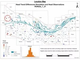

Water Level Observations and Drain Elevations in Northwest Keith County
E N D
Presentation Transcript
Northwest Keith County – Water Level Observations Vs. modeled Drain Elevations 3493 ft SI1886 3524 ft 3524 to 3480 ft 3460 ft SI1855 3400 ft 3380 to 3355 ft 3354 ft 3336 ft SI1774 3364 ft 3358 to 3325 ft
Hydrograph for SI1380 Is this a Good Water Level Target?