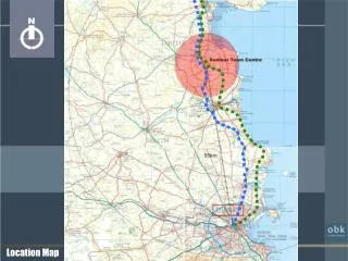
LOCATION MAP
APPLICATION # 2457 GRAND HAVEN PUD AMENDMENT APPLICATION # 2411 GRAND HAVEN NORTH: SMALL SCALE FLUM AMENDMENT APPLICATION #2412 GRAND HAVEN NORTH: MASTER PLANNED DEVELOPMENT. LOCATION MAP. Palm Coast Parkway. Grand Haven North Project Surrounding Land Uses: North, South, and West:

LOCATION MAP
E N D
Presentation Transcript
APPLICATION #2457GRAND HAVEN PUD AMENDMENTAPPLICATION #2411GRAND HAVEN NORTH: SMALL SCALE FLUM AMENDMENTAPPLICATION #2412GRAND HAVEN NORTH: MASTER PLANNED DEVELOPMENT
LOCATION MAP Palm Coast Parkway Grand Haven North Project Surrounding Land Uses: North, South, and West: Single-family and Open Space/Preservation East: Daytona State College Blare Drive Colbert Lane
LOCATION MAP Palm Coast Parkway • Amendment to Grand Haven PUD – App # 2457 • 5.82 acres from Grand Haven PUD to Grand haven North MPD • Small-Scale FLUM & Text Amendment – App # 2411 • 9.3 acres: 7.3 acres to mixed use and 1.9 to Conservation and commitment for 16- acres to Conservation. • Rezoning to MPD – App #2412 • 71. 4 acres – 58 acres preservation • 13- acres developed Blare Drive Colbert Lane
Existing Development Potential Zoning: General Commercial – 5.96 acres PUD – 5.82 acres Maximum Commercial Floor Area Commercial – 188,847 sq. ft. Maximum Building Height 100 feet Zoning: Estate – 1 – 16.36 acres Permitted Residential Units – 16 Preservation Area (No Development Potential): – 35.13 acres .
Proposed Development Potential • Zoning: • Master Planned Development (MPD) – 71.4 acres • - 216 units (continuing care adult retirement community) • 25,000 sq. ft. Commercial-retail/office • Maximum Building Height: • - 60’ residential • - 45’ Commercial-retail/office • Preservation Area (No Development Potential): • - 58 acres (82% of MPD area - increase of 16+/- acres of preservation lands)
Grand Haven PUD Amendment Palm Coast Parkway • Grand Haven North Project • 5.82 acres in existing Grand Haven PUD • Delete 5.82 acres from Grand Haven PUD to become part of proposed Grand Haven North MPD. • Current PUD provides for commercial development Blare Drive Colbert Lane
FUTURE LAND USE MAP AMENDMENT EXISTING PROPOSED 1 1 2 3 3 2
TEXT AMENDMENT Policy 6.1.10.10: To address the impacts of the Grand Haven North FLUM amendment on the area’s environmental resources, a minimum of sixteen (16) acres of similarly situated, adjacent land shall be designated as “Conservation” on the Future Land Use Map.
FUTURE LAND USE MAP AMENDMENT • Proposed impacts remain within the established Level of Service (LOS) standards. • Designation of 16 acres as “Conservation” provides a net increase of 14.5 acres of “Conservation” land.
MPDZONING MAP: MASTER PLANNED DEVELOPMENT EXISTINGPROPOSED
MPD DA PRESERVATION AREAS * Parcel to be changed to Conservation on the FLUM within six months of the MPD rezoning approval by City Council.
MPD CONCEPTUAL DEVELOPMENT AREA PLAN For Illustrative Purpose Only
MPD DEVELOPMENT AGREEMENT HILITES 3. Conservation Easement: In order to provide optimal protection of the natural vegetative systems, conservation easements shall be executed for Parcels No. 07-11-31-7081-ORP0D-0020, 07-11-31-7081-RP0D2-0000, 42-11-31-000-01010-0040, 42-11-31-0000-01010-0051, approximately 4.7+/- acres within parcel 17-11-31-0000-01030-0020, and approximately 1.93+/- acres within parcel 17-11-31-0000-01031-0000. The conservation easements shall be executed during the platting or site plan process. 4. Permitted Uses: Residential uses: Restricted to senior living facilities, adult day care center, and skilled nursing facilities with a maximum 25,000 square feet of commercial/office space. 1. Project will generally consist of the following: • 72+/- acres • Developed area - 14+/- acres • Undeveloped area – 58+/- acres • Residential units – 216 maximum (subject to Section 3b.) • Commercial office space – 25,000 square feet of gross floor area • Recreation amenities (clubhouse, pathways, etc.) 2. Greenbelt Parcel (16.23 +/- acres): The Owner agrees that the City will initiate a Future Land Use Map Amendment within six (6) months of adoption of the MPD rezoning ordinance for the 16. 23+/- acre portion of Parcel ID 07-11-31-7081-ORPOD-0020. Specifically, the FLUM amendment will change the current FLUM designation of the area designated Greenbelt to Conservation.
MPD DEVELOPMENT AGREEMENT HILITES 5. LOW IMPACT DEVELOPMENT PRACTICES: To further conservation practices identified in the LDC, the Project shall incorporate into the construction, operation, and maintenance of all facilities, conservation strategies to include but not be limited to: Water Conservation: i. Native, drought tolerant plant materials; ii. St. Johns River Water Management District Florida Water Star program for protection of water resources; iii. Turf grass – Irrigated area(s) shall not exceed 50% of landscape areas; iv. Separate irrigation zones shall be required for turf, non-turf areas; and v. Landscape areas shall not be irrigated using high-volume irrigation systems unless high pressure compensating spray heads are utilized. 6. WILDLIFE PROTECTION: In the event that listed species have been determined to be residing on, or otherwise be significantly dependent on the Subject Property, the Owner shall obtain the necessary permits from the FWC or other applicable agencies. Activities associated with listed flora and fauna shall comply with the LDC. Bear Smart Community principles shall be integrated into design and operations. The intent is to minimize human-animal conflicts from black bear and other species that may inhabit or move through off-site conservation lands.
DEVELOPMENT POTENTIAL SUMMARY CURRENT Zoning: General Commercial – 5.96 acres PUD – 5.82 acres Maximum Commercial Floor Area Commercial – 188,847 sq. ft. Maximum Building Height 100 feet Zoning: Estate – 1 – 16.36 acres Permitted Residential Units – 16 Preservation Area (No Development Potential): – 35.13 acres PROPOSED Zoning: Master Planned Development (MPD) – 71.4 acres 25,000 sq. ft. gross floor area 216 units (continuing care adult retirement community) Maximum Building Height: 45’ non-residential 60’ residential Preservation Area (No Development Potential): 59 acres (82% of MPD are - increase in 14+/- acres)
NEXT STEPS: APPLICATION PROCESS 1. CURRENT APPLICATIONS: #2457 - Amendment to Grand Haven PUD Development Agreement #2411 - Future Land Use Map Amendment #2412 - Master Planned Development Rezoning City Council – 2 Public hearings 2. FUTURE APPLICATIONS • Final Plat City Council 2. Technical Site Plan (Residential Development) Neighborhood Meeting Planning and Land Development Regulation Board (Recommendation to City Council) City Council – Final Action
RECOMMENDATION Grand Haven Amendment to Planned Unit Development Agreement - Approve Application #2457 the amendment to the Grand Haven Planned Unit Development as provided for in Ordinance 2012-xx Small Scale Future Land Use Amendment: – Approve Application #2411 the Small Scale Future Land Use Amendment as provided for in Ordinance 2012-xx Master Planned District Rezoning: – Approve Application #2412 the Grand Haven North Master Planned District rezoning as provided for in Ordinance 2012-xx