Differential GPS
Differential GPS. An Introduction. How does it work. Method of Differential Correction. The reference ground station(s) at known locations receive NAVSTAR signals. Knowing position of the station, the pseudo-range to each SV is calculated based on the almanac

Differential GPS
E N D
Presentation Transcript
Differential GPS An Introduction
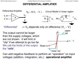
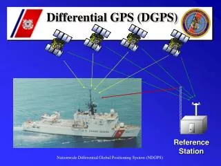
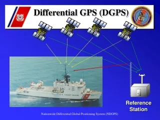
Method of Differential Correction • The reference ground station(s) at known locations receive NAVSTAR signals. • Knowing position of the station, the pseudo-range to each SV is calculated based on the almanac • The measured pseudorange, PRM(t), is determined • The pseudorange correction is calculated as the difference • The pseudorange correction, PRC(t), and the Range Rate Correction RRC(t) are sent from the reference ground station
Method of Differential Correction • Local GPS calculates corrected position Corrected pseudorange = pseudorange measured + pseudorange correction PR(t) = PRM(t) + PRC(t)
Local GPS Communications • NMEA 0183 used to communicate fix data from GPS devices • Serial character data • Baud Rate 4800 • Data Bits 8(d7=0) • Parity None • Stop Bits One(or more) • RTC SC 104 used to communicate differential data • Serial character data
RTCM SC 104 • Specification for the signal used to transmit differential correction to a GPS ground receiver • Format is referred to as the RTCM-104 format (Radio Technical Commission for Maritime Services Special Committee No. 104)
RTCM SC 104 Messages • Type 3 - Station coordinates • Type 9 - (Fast Type 1) Correction data • Scale Factor (.02 m and .002 m/s or .32 m and .032 m/s) • User Differential Range Error • 1 sigma error is < 1,2,4,8,greater • Satellite ID - PRN code • PRC - Pseudorange correction • RRC - Range Rate Correction • Issue of Data - Link to the particular GPS data from which calculations are derived • … • Sent in 30 bit words including a 5 bit parity
NMEA 0183 Example • Global Positioning Fix Data • $GPGGA,120757,5152.985,N,00205.733,W,1,06,2.5,121.9,M,49.4,M,,*52 • Synopsis: • time of fix (hhmmss) • latitude • N/S • longitude • E/W • Fix quality (0=invalid, 1=GPS fix, 2=DGPS fix) • number of satellites being tracked • horizontal dilution of position • altitude above sea level • M (meters) • height of geoid (mean sea level) above WGS84 ellipsoid • time in seconds since last DGPS update • DGPS station ID number • checksum
How to determine Health of the NAVSTAR and Coast Guard Systems • Check the Coast Guard web site for status • http://www.nis-mirror.com/default.html