Download
1 / 19
190 likes | 205 Vues
Explore intercalibration methods using AIRS data to enhance accuracy in geostationary imager readings. Learn about spectral response differences and future research prospects in satellite calibration and validation.

E N D
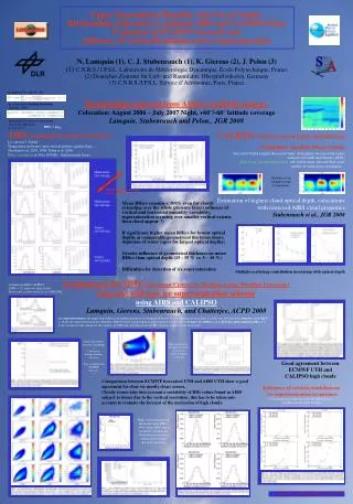
AIRS/GEO Infrared Intercalibration Mat Gunshor, Tim Schmit, Paul Menzel, and Dave Tobin NOAA/NESDIS Cooperative Research Program Second Annual Science Symposium SATELLITE CALIBRATION & VALIDATION July 13-14, 2005 Pyle Center, 702 Langdon Street University of Wisconsin-Madison http://cimss.ssec.wisc.edu/corp/
PURPOSE • Intercalibrate the world’s operational geostationary imagers with a single polar-orbiter. • Assess radiometric accuracy. • Especially important during post-launch check-outs.
Must account for spectral response function differences between broad-bands channels. Comparisons can only show differences between instruments; they cannot truly measure calibration accuracy.
Why AIRS? • AIRS has been proven to be extremely well calibrated. • Hyperspectral data can be manipulated spectrally to fit nearly any broadband instrument. • AIRS can be used for both quick and long-term intercalibration. Drawbacks to AIRS • AIRS footprint size is rather large (~13km) compared to geostationary imagers with 3-5km footprints (is also a problem with HIRS). • There are spectral gaps (some very large) in AIRS data
METHODS • Collocation in time and space. • Within 30 minutes at geostationary subpoint • Low Satellite View Angles (< 14)
METHODS • Collocation in time and space. • Within 30 minutes at geostationary subpoint • Low Satellite View Angles (< 14) • Spatial smoothing • 100km “running average” mitigates the negative effects of poor spatial and temporal collocation, poor navigation, and spatial resolution differences. • Average radiances, not temperatures. • Convolve AIRS Radiance spectra with GEO SRF. • Compare mean scene brightness temperatures (converted from mean scene radiances).
Lat Lon MTSAT 11m 07 July 2005 at 15:33UTC
Lat Lon AIRS convolved with MTSAT 11m 07 July 2005 at 15:36UTC
Lat Lon 100km-smoothed MTSAT comparison area
Lat Lon 100km-smoothed AIRS convolved with MTSAT comparison area (Tbb = -0.4 K)
1-23 June 2005 11m IR Window Brightness Temperature Differences (GEO-AIRS)
1-23 June 2005 6.8m (7.3m)Water Vapor Brightness Temperature Differences (GEO-AIRS with spectral gaps)
Meteosat-8 7.3m Spectral Response (blue) with AIRS spectra (black). Gaps filled with adjusted US Standard Atmosphere spectra (green).
6.8m (7.3m)Water Vapor Brightness Temperature Differences (GEO-AIRS). Before 6.8m (7.3m)Water Vapor Brightness Temperature Differences (GEO-AIRS). Before and After filling gaps.
SUMMARY • The infrared bands on most geostationary imagers are well calibrated to within specifications (1K) for most bands. • A simple technique to fill AIRS spectral gaps with a modified US Standard Atmosphere spectra improves comparisons for several bands. • AIRS can be used for both quick and long-term intercalibration.
FUTURE WORK • Fill spectral gaps with AIRS retrieval • GIFTS forward model • Process more cases / new satellites • IASI – Full Spectral Coverage (~8,000 channels) • GOES-R • Advanced Baseline Imager (16 bands) • Hyperspectral Environmental Suite (Sounder) • There will still be spectral gaps. • http://cimss.ssec.wisc.edu/goes/intercal/