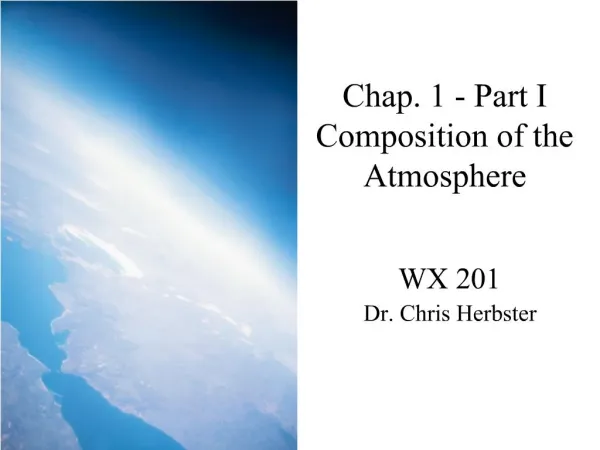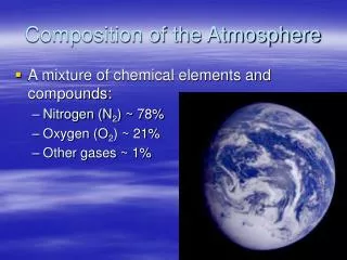
Composition of the Atmosphere
1.82k likes | 4.96k Vues
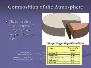
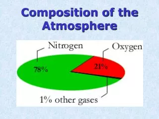
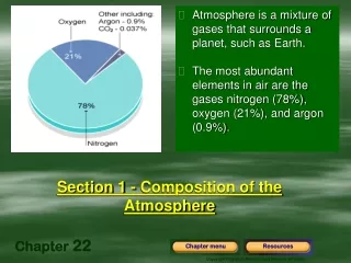
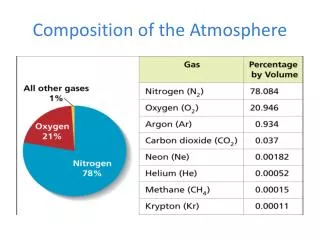
Composition of the Atmosphere. Layers of the Atmosphere. The Troposphere: The lowest layer of the atmosphere; next to the Earth’s surface. It’s where most weather takes place. The Stratosphere: Home of the Ozone Layer The atmospheric layer above the troposphere. . The Mesosphere:

Composition of the Atmosphere
E N D
Presentation Transcript
Layers of the Atmosphere • The Troposphere: • The lowest layer of the atmosphere; next to the Earth’s surface. • It’s where most weather takes place.
The Stratosphere: • Home of the Ozone Layer • The atmospheric layer above the troposphere.
The Mesosphere: • The Middle Layer • It is also the coldest layer.
The Thermosphere: • The uppermost edge of the atmosphere • Contains the Ionosphere: • Home of the Auroras • In the upper mesosphere and the lower thermosphere, nitrogen and oxygen atoms absorb harmful solar energy.
EXIT SLIP:Create a T chart: on one side labeled “What I know,” and the other “What I have learned.”
Objectives • I will know how air masses become fronts • I will be able to explain the difference between the four different types of fronts.
Weather Foldable • Open the Large pocket and label Types of Fronts on top and Air Masses on the bottom panel.
Weather Foldable • Close it up and write 2 more headings: Layers of the Atmosphere and Highs and Lows.
Air Masses An air mass is a large body of air that has fairly uniform physical properties, such as temperature and moisture content. Write these notes to the left of the Air Masses picture.
Air Masses cont’d Air masses are classified according to whether they form over water or land, and the latitude where they form. U
Paste FRONTS pictures on left Make a Chart with 2 headings: “How it Forms” and “Weather it Brings”
Fronts (Look and Listen!!) Air masses move with the circulation of air throughout the planet. • When different air masses meet, they ordinarily don’t mix. Instead, a boundary forms between them, called a FRONT.
Risingwarmair Cold air masssinks under thewarm air mass. Directionof front Precipitation Fronts A cold front forms when a cold air mass overtakes a warm air mass. Cold fronts often bring strong winds, severe thunderstorms, and large amounts of precipitation. Label the drawing provided in your notes appropriately.
Clouds form asrising moist, warmair condenses. Risingwarm air Directionof front Cold air masssinks under thewarm air mass. Precipitation Fronts A warm front occurs when a warm air mass overtakes a cold air mass. Occasionally heavy showers or thunderstorms occur. Label the drawing provided in your notes appropriately.
Fronts Stationary Fronts • When two unlike air masses have formed a boundary but neither is moving, the front is called a stationary front. • Stationary fronts often result in clouds and steady rain or snow for several days. Label the drawing provided in your notes appropriately.
Fronts Occluded Fronts An occluded front forms when a warm air mass is caught between two cooler air masses. • Occluded fronts usually bring cloudy skies and precipitation. Label the drawing provided in your notes appropriately.
Cold Front Warm Front Stationary Front Occluded front
Objectives • I will know how different storms form and how they produce damage. • I will be able to explain the difference between a cyclone and anticyclone.
Low- and High-Pressure Systems Air masses are part of larger weather systems. Weather systems are organized around either a center of high air pressure or a center of low air pressure, and may include more than one type of air mass. • Low Pressure is generally bad weather • High Pressure is generally good weather.
First 10 minutes– label the cutout of the layers of the atmosphere and glue it under your heading, “Layers of the Atmosphere.” • Finish the “Fronts” notes from yesterday.
Low- and High-Pressure Systems Cyclones (Lows)A weather system with a center of low air pressure is called a cyclone. • Because air moves from high-to low-pressure areas, air spirals in toward the center of a cyclone. Generally BAD weather. Anticyclones (Highs)A weather system with a swirling center of high air pressure is called an anticyclone • Because the center of an anticyclone has high pressure, air flows away from that center. Generally GOOD weather.
Pressure Gradient Force • Air flows from high pressure to low pressure. • This is why the wind blows!
Storms and Precipitation • You’ll make 2 Post-It Flip Books on the back of your foldable; one labeled STORMS; the other, PRECIPITATION.
Storms Thunderstorms: Cold front lifts warm, moist air quickly, forming a cumulonimbus cloud. The result is lightning, thunder, and heavy rains. Heavy T-Storms, like supercells, are dangerous because they tend to drop tornadoes!
Storms Tornadoes • Intense windstorms that take the form of a rotating column of air that touches the ground. • Tornadoes most often form at the leading edge of an advancing cold front.
Storms Tropical Storms and Hurricanes Cyclones also develop in the tropics, where they can develop into tropical storms or hurricanes. A hurricane is a large tropical cyclone with winds of at least 119 kilometers per hour (74 miles per hour). They are fueled by moist, warm air. This is whey they die when they make landfall.
Precipitation • Snow: Ice crystals that vary due to the temp at which they form.
Precipitation • Rain: Collision and coalescence of water in the atmosphere. All rain begins as ICE! • Sleet: Falls through a cold layer of air, then a warm layer, then another cold layer.
More winter Stuff… • Freezing rain: Like sleet, but the cold layer at the surface is much thinner, so it doesn’t solidify before hitting the ground. It solidifies after.
More winter Stuff… • …Other weird stuff: • Virga: Precipitation that doesn’t reach the ground.
More winter Stuff… • Graupel: Pellet-like snowy stuff that forms when lots of supercooled water and ice accrete before falling. Usually happens on mountains.
Awwww HAIL no…. • Hail: Happens when a T-Storms updraft is so strong that ice crystals just bounce and grow until they become heavy and fall.
Wow That’s Fantastic • Frogs: Not kidding. A small water-tornado called a waterspout can carry small organisms (tadpoles, frogs) into the air and dump them on land when it dissipates.