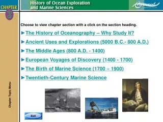
Exploration Routes: Mapping the Age of Discovery (1492-1522)
40 likes | 181 Vues
This activity involves drawing and labeling the routes taken by famous explorers such as Columbus, Cabral, Hudson, and Magellan on a blank map. Students will color countries according to a provided key and underline crucial locations such as India, China, and Indonesia. The task aims to demonstrate how Spanish explorers fanned out into North and South America during the 1500s and analyze the impact of these explorations on global trade and cultural exchanges. Perfect for learning about the Age of Discovery through a hands-on approach.

Exploration Routes: Mapping the Age of Discovery (1492-1522)
E N D
Presentation Transcript
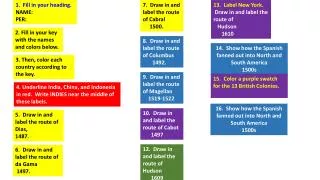
1. Fill in your heading. NAME: PER: 7. Draw in and label the route of Cabral 1500. 13. Label New York. Draw in and label the route of Hudson 1610 2. Fill in your key with the names and colors below. 8. Draw in and label the route of Columbus 1492. 14. Show how the Spanish fanned out into North and South America 1500s 3. Then, color each country according to the key. 9. Draw in and label the route of Magellan 1519-1522 15. Color a purple swatch for the 13 British Colonies. 4. Underline India, China, and Indonesia in red. Write INDIES near the middle of these labels. 16. Show how the Spanish fanned out into North and South America 1500s 10. Draw in and label the route of Cabot 1497 5. Draw in and label the route of Dias, 1487. 12. Draw in and label the route of Hudson 1609 6. Draw in and label the route of da Gama 1497.
Show how the Spanish fanned out into North and South America 1500s Hudson 1610 Cabot 1497 Cartier 1536 New York Hudson 1609 Reference Map Columbus 1492 Indies Da Gama 1497 Dias 1487 Indonesia Magellan’s Crew 1519-1522 Cabral 1500 Magellan 1519-1522 Portugal Spain England France The Netherlands
Link to “Map Analysis W/S” Link to “BLANK MAP Legal Sized