Download
1 / 15
150 likes | 303 Vues
Discover Perak Tourism Icons Through Web GIS. Dato ’ Dr. Dolbani Mijan Director Perak Town & Country Planning Department. OUTLINE. BACKGROUND OBJECTIVE HOW IT’S DONE CONCLUSION. BACKGROUND. Perak is a state which is rich with tourism attractions

E N D
Discover Perak Tourism Icons Through Web GIS Dato’ Dr. DolbaniMijan Director Perak Town & Country Planning Department
OUTLINE • BACKGROUND • OBJECTIVE • HOW IT’S DONE • CONCLUSION
BACKGROUND • Perak is a state which is rich with tourism attractions • Such as natural attractions, man made attractions, agricultural, and heritage and culture • Perak Introduces 10 Tourism Icons for the Visit Perak Year 2012
BACKGROUND • The 10 Tourism Icons for Perak Visit Perak Year 2012
HOW IT’S DONE GEOSERVER : Manage and Publish layers using OGC Web Map Services e.g. WFS / WMS
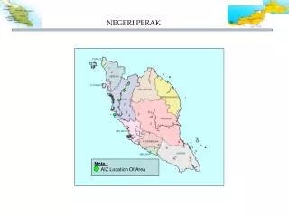
BACKGROUND • JPBD Perak has maintained some layers that relate to tourism attraction as part of Perak-GIS data layer but have never been publish to web.
MAP AVAILABILITY • Some limited and Uninteractive maps are available
OBJECTIVE • To publish our current data layer on Tourist Attractions in Perak • To develop know-how on WEB-GIS development using some FOSS4G solutions • Complement existing Perak Tourism Website
HOW IT’S DONE • Existing data conversion & Enhancement • Prepare data layer and publish it as MAP SERVICES using Geoserver • Develop client using Openlayers • Serve the client web via WEB SERVER
HOW IT’S DONE Serve Publish Map Services Interactive Map Develop Web Map Client c Data preparation /conversion Mash-up e.g. Google Map/ OSM
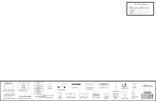
LOOK n FEEL Map Panel MapTools Layer Treel Legend Panel
CONCLUSION • Created tourist map that portray the 10 icon of Perak • We’ve developed know how in term of developing Web GIS by using new approach • Able deliver more geospatial information to the Perak-GIS stakeholder in efficient way.
pengarah_jpbd@perak.gov.my jpbd.perak http://jpbd.perak.gov.my THANK YOU