Download
1 / 47
470 likes | 485 Vues
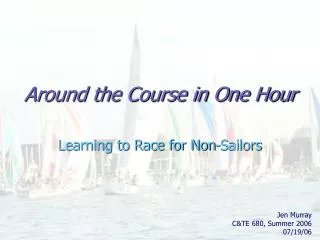
Learn about the time it takes for tsunami waves to reach their destinations and the importance of emergency preparedness in coastal communities. Find out how to calculate arrival times, identify the source of tsunamis, and understand the necessary precautions. Discover the historical impact of tsunamis in Hawaii and the need for public education and warning systems. Get an emergency preparedness checklist and essential items to include in your emergency plan.

E N D
The time it takes for the waves to reach their destinations depends on where the earthquake occurs. A tsunami caused by an earthquake a few kilometers miles off the coast is called a "near field" or "locally generated" tsunami. Residents of coastal communities probably will feel such an earthquake. The first wave might reach shore in only a few minutes.
One-hour Tsunami Travel Times for Simulated Seismic Zones in the Pacific Ocean
Tsunami Arrival Time : One-hour Tsunami Travel Times Pacific Ocean North America Japan Asia Hawaii South America Australia Antarctica
Hawaii Tsunami Arrival Time : One-hour Tsunami Travel Times for Simulated Seismic Zones in the Pacific Ocean
Pacific Ocean Kauai 50 40 Oahu 30 Molokai Maui Lanai 20 Hawaii 20 Tsunami Arrival Time 2-minute Tsunami Travel Times for Simulated Seismic Zones in the Hawaiian Isles Earthquake Epicenter Map Scale 1 cm = 25 kilometer
1. Calculate the Arrival time and speed of a Hawaii-Kona coast tsunami 2. List the source of the tsunami and probable cause. 3. Would you have adequate time at your location for emergency response? 4. What precaution need to be taken in a shoreline area?
In Hilo, Hawaii, the 1960 Chilean tsunami left 61 people dead and 282 seriously injured. Although warning sirens sounded more than 3 hours before the first waves arrived, the meaning of these signals was not clear
The town clock of Waiakea, a Hilo suburb, stopped at 1:04 a.m. when the biggest wave of the 1960 Chilean tsunami struck Hawai’i. The clock, still showing that time, now stands as a monument to the 1960 tsunami
Aftermath of the 1960 Chilean tsunami in Hilo, Hawaii, where the tsunami caused 61 deaths.
The 1960 Chile earthquake produced a series of tsunami waves that crossed the Pacific Ocean. This record shows measurements of water levels beneath the Wailuku River Bridge during the first few hours of the tsunami in Hilo, Hawaii.
A robust warning scheme is only part of the story, however. Equally important is public education. A tsunami from South Kona would reach Kailua-Kona in five minutes, Kihei in twenty minutes, Honolulu, Waianae, and Kaanapali in thirty minutes, and Lihue in thirty-seven minutes. Protection of the public from such an event necessarily demands educating the public about how to protect themselves. Tsunami warning is as much a social problem as a scientific one http://www.soest.hawaii.edu/tsunami/index.html
Could It Happen Here? Tsunamis That Have Struck Hawaii One lesson that everyone around the world can learn from this devastating event is to heed the natural warning signs of an approaching tsunami: if you feel the ground shaking near the coast or if you see an unusual disturbance of the ocean, such as the water withdrawing far from shore, it is important to move to high ground. Because of the complex behavior of tsunami waves near the coast, the first wave of a tsunami is generally not the largest, emphasizing the importance of staying away from the coast until wave activity has subsided (commonly several hours or even days).
Unanswered questions until the next tsunami • When the inevitable tsunami strikes the islands, will the Warning Centers’ urgent messages reach the residents? • Will the Warning Centers be staffed 24 hours, seven days a week? • Will authorities be able to put evacuation plans into effect when they receive a tsunami warning?
EMERGENCY PREPAREDNESS CHECKLISTS10 ESSENTIAL ITEMS For Your Emergency Plan Emergency Supplies Evacuation
Emergency Plan Checklist 10 ESSENTIAL ACTIONS 1. Learn the threats in your area 2. Identify meeting places • Outside of your home • Outside of your neighborhood 3. Select your out-of-state contact 4. Know your evacuation routes • Exits and alternate ways to leave home 5. Know the location of utility shut-offs • Water • Gas • Electricity 6. Know the policies of schools, day-care and adult-care centers • Emergency shelter/supplies • Transportation 7. Identify safe spots in each room to take cover, if needed • Under sturdy tables and desks • Against interior walls 8. Extra medications 9. Make special provisions for: • Children • Seniors • Pets • People with Disabilities • Non-English speaking 10. Schedule annual disaster drills
Emergency Supplies Checklist : 10 ESSENTIAL SUPPLIES Emergency Supply Kit 1. Water (three days to a week supply—one gallon per person per day—Remember pets) 2. Food (three days to a week supply of non-perishable foods and manual can opener— remember pets) 3. First aid kit and manual 4. Flashlights (and extra batteries) 5. Radio (and extra batteries) 6. Medications (over-the-counter, prescriptions, and prescription lists) 7. Cash and important documents (small bills and coins, deeds, insurance papers, medical cards, etc.) 8. Clothing and sturdy shoes 9. Tools: adjustable wrench, fire extinguisher, gloves, whistle 10.Sanitation and hygiene supplies
Evacuation Checklist: 10 ESSENTIAL ITEMS 1. Emergency Supply Kit 2. Out-of-State Contact List 3. Cash and Credit Cards 4. Important Documents: Social Security card, Drivers license, Passport, Medical card and records, Insurance information 5. Change of Clothing: For each family member 6. Personal Hygiene Items: Toothbrush and toothpaste, Shampoo and soap, Lotion, Deodorant, Kleenex and toilet tissue 7. Family Photos 8. Baby Items: Diapers,Formula, Food, Change of clothing 9. Special Needs Items: Wheelchair, canes, & walkers,Medications, Hearing aids (& extra batteries) 10. Pet Care Items: Identification & immunizations, Carrier or cage, Muzzle and leash, Food and water See www.espfocus.org formore detailed information
Travel times for a tsunami generated off the Kona coast. Kona earthquakes and landslides pose a serious local tsunami hazard for Hawai'i. While other phenomena, such as the complete sector collapse of one of the islands, would produce a far more damaging tsunami, such phenomena are exceptionally rare (perhaps occurring once every 50,000 years). By contrast, Kona earthquakes large enough to generate damaging tsunamis probably occur every few hundred years. This maps shows how rapidly people will have to respond to a Kona event. The map shows the arrival times, in minutes, of the first wave of the tsunami. The source is the red area off Kona. If such an event occurs, the Kona coast will be inundated within 5 minutes, and the southern shores of Maui, Moloka'i, and O'ahu in 30 minutes.
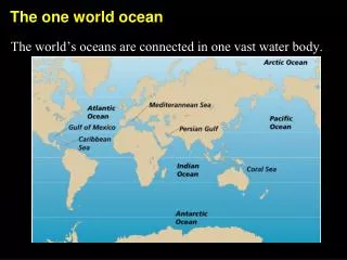
Tsunamis are generated by subduction zone earthquakes, earthquakes that occur where one lithospheric plate is sinking beneath another. These are the big, destructive earthquakes that occur not in Hawaii but around the edges of the Pacific. A good example is the subduction of the Pacific Plate beneath the North American Plate along the south coast of Alaska and out along the Aleutian Islands.
http://www.prh.noaa.gov/ptwc http://www.thehawaiichannel.com/video/13402559/index.html Rockfall Diamond Head 05/28/2007 news video
• Spatial trends may be interpreted through isolines. • Increases/decreases in the values of interest may be determined from isolines. • The relative increase/decrease of the values of interest may also be determined. • The value difference between any two consecutive isolines is the isoline interval. Isoline Interval 2 units, 2 C isotherm 2 minutes, isotime or isominute Contour iso Height
Isoline Trends The relative increase or decrease of a certain value may also be determined. • Tight spacing between isolines depict relatively sharp increases or decreases in values. •Wide spacing between isolines depict relatively small increases or decreases in values. Sharp increase Slight increase
Focus Plate (Land-side) Sea Trench The Pacific Plate
Evacuation Zone Mapshttp://www.honolulu.gov/ocda/maps.htm KCC
Evacuation Zone Mapshttp://www.honolulu.gov/ocda/maps.htm KCC
Villagers run to collect relief packages dropped by helicopters over Bihar in north-east India, one of the areas badly affected by flooding during the worst monsoon rains in decades. 08/07/2007