Download
1 / 18
180 likes | 393 Vues
Northwest Pacific Tsunami Advisory Center. Japan Meteorological Agency. Northwest Pacific Tsunami Advisory Center. JMA Headquarters. Countries in Northwest Pacific Ocean. Japanese Seismic Network. Northwest Pacific Tsunami Advisory.

E N D
Northwest Pacific Tsunami Advisory Center Japan Meteorological Agency
Northwest Pacific Tsunami Advisory Center JMA Headquarters Countries in Northwest Pacific Ocean Japanese Seismic Network Northwest Pacific Tsunami Advisory Analysis of seismic data and estimation of arrival time and height of tsunami generated by earthquakes in the Northwest Pacific Area - Origin Time - Hypocenter - Magnitude (>=6.5) - Estimated arrival time and height of tsunami Global Seismic Network Through the Global Telecommunication System of WMO, E-mail and/or Facsimile Information Exchange - Magnitude - Hypocenter - Tsunami Information Pacific Tsunami Warning Center (PTWC)
Northwest Pacific Tsunami Advisory OBJECTIVE ●To offer useful information including tsunami amplitude forecasts ●To cover the marginal seas adjacent to Northwest Pacific In conjunction with the tsunami bulletins from PTWC As an advisory for the actions taken by the recipient countries such as alerting the people and announcing evacuation notices on their own responsibility
Coverage area of NWPTA March 2005 April 2006
Seismic Waveform Data Collection for Northwest Pacific Tsunami Advisory WorldwideNetwork(Broadband Stations) IRIS/USGS(accessing LISS servers) and IRIS/IDA(accessing IRIS server) seismic data via the Internet.
Seismic waveforms from IRIS Port Moresby Honiara Charters Towers Kwajalein Guam Tennat Creek Wake Island Stephens Creek Chichi jima Afiamalu
8m以上 8m~2m 4m~2m 2m~1m 1m以下 8m以上 8m~2m 4m~2m 2m~1m 1m以下 8m以上 8m~2m 4m~2m 2m~1m 1m以下 Quantitative Tsunami Forecast System of JMA Hypoceneter Magnitude Numerical Simulation Database Even a most-advanced computer needs much time to simulate tsunami propagation! Tsunami Amplitude Arrival Time
Means of dissemination • Global Telecommunication System (GTS) of World Meteorological Organization (WMO) • WEPA40 RJTD • E-mail • Facsimile
Background seismicity (M>=6.5,d<=100km) & distribution of disastrous earthquakes in the past Ref. Utsu (personal comm.) for 801-2001 PDE for 2002- (M>=6.5, d<=100km)
Pacific Wave ‘06 source Tsunami Travel Time Estimated Tsunami Amplitude Amplitude (m)
Pacific Wave ’06 Quantitative Tsunami Forecast System Elapsed Time 5 M. 10 M. 15 M. 20 M. 25 M. 30 M. 1 H. EQ. NWPTA 001 NWPTA 002 Detection of Earthquake Determination of HYP. & M Information from PTWC Tsunami Observation Ishigakijima Naha ETA & AMP. HYP & M
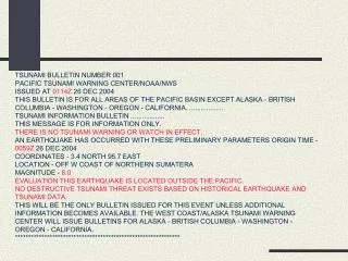
Northwest Pacific Tsunami Advisory CONTENTS 1 Earthquake Information 2 Evaluation of Tsunamigenic Potential 3 Estimated Amplitude and Arrival Time of Tsunami 4Tsunami Observation Data
Example of Northwest Pacific Tsunami Advisory Earthquake Information Potential of Tsunami
Example of Northwest Pacific Tsunami Advisory(continuation) Estimated Tsunami Height
Example of Northwest Pacific Tsunami Advisory(continuation) Tsunami Observation