Download
1 / 26
260 likes | 459 Vues
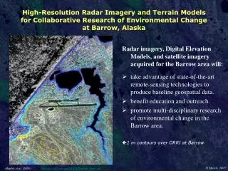
High-Resolution Radar Imagery and Terrain Models for Collaborative Research of Environmental Change at Barrow, Alaska. Radar imagery, Digital Elevation Models, and satellite imagery acquired for the Barrow area will:

E N D
High-Resolution Radar Imagery and Terrain Models for Collaborative Research of Environmental Change at Barrow, Alaska Radar imagery, Digital Elevation Models, and satellite imagery acquired for the Barrow area will: • take advantage of state-of-the-art remote-sensing technologies to produce baseline geospatial data. • benefit education and outreach. • promote multi-disciplinary research of environmental change in the Barrow area. • 1 m contours over ORRI at Barrow 31 March, 2005 Manley et al. (2005) instaar.colorado.edu/QGISL/barrow_high_res
Collaborators Richard Beck, Kenneth Hinkel, & Wendy Eisner Glenn Sheehan Jerry Brown Anne Jensen Tim Buckley Frederick Nelson & Anna Klene Patrick Webber Rudolf Dichtl University of Cincinnati Barrow Arctic Science Consortium International Permafrost Association Ukpeagvik Inupiat Corporation Barrow High School University of Delaware Michigan State University ARCSS Data Coordination Center The project is broadly collaborative. Investigators William Manley1, Leanne Lestak1, Craig Tweedie2, and James Maslanik1 1 University of Colorado, 2 Michigan State University Funded by NSF / OPP, Arctic Research Support and Logistics Program
Scientific research is concentrated at Barrow. Categories of NSF-funded research conducted in the Barrow area (and number of awards as of 2002). $Millions are dedicated each year by NSF to research in the Barrow area, including the Barrow Environmental Observatory (BEO). Other research is supported by IARC, DOE, USGS, EPA, NASA, and other agencies.
The Problem: Existing GIS layers and satellite imagery are incomplete in time and space, highly non-uniform, and of varying quality. Existing geospatial datasets are often difficult or impractical to use, because they vary in: • Map projection • Datum • Extent • Data format • Timeframe • Spatial resolution • Horizontal & vertical accuracy • Accessibility • Metadata and documentation standards
A Solution: IFSAR OrthoRectified Radar Imagery IFSAR Digital Elevation Models with “value-added” processing & layers • UTM zone 4 • NAD83 • Barrow Peninsula and Triangle • GeoTIFF, shapefile, ArcGRID, and floating-point raster • July 27–29, 2002 • High resolution • Highly accurate • Accessible • Well documented
Intermap IFSAR Products (GT1 Product Level for “Barrow Peninsula”: 2350 km2; acquired July 27-29, 2002) • Digital Surface Model (DSM) • surface reflectance elevation • 5 m grid cells, 13,020 rows x 14,461 columns • vertical accuracy of +/- 1.0 m or better (RMSE) • horizontal accuracy of +/- 2.5 m or better (RMSE) • best for detailed visualization and analysis • Digital Terrain Model (DTM) • custom “Bald-Earth Lite” process for North Slope • Terrain Fit processing and median filter to remove speckle noise in very low-relief coastal plain • 5 m grid cells, 13,020 rows x 14,461 columns • accuracies unspecified but comparable to DSM • best for derived layers (e.g., slope angle, contours, etc.) • OrthoRectified Radar Imagery (ORRI) • radar surface reflectance • 1.25 m pixels, 52,080 rows x 57,844 columns • horizontal accuracy of +/- 1.25 m or better (RMSE) • both unenhanced and contrast-stretched versions • best for visualization, mapping, various analyses
IFSAR data as delivered (26 tiles across 2 UTM zones) • Difficult to work with!
21 files for each of the 26 tiles Certification Report tilename... (e.g. barb4sw...) ...cx.pdf (acquisition details) ...mb.bil ...mb.hdr ...mb.prj ...mb.txt ...mb.html ...mb.xml floating point binary file header file projection file FGDC metadata FGDC metadata FGDC metadata tilename... (e.g. barb4sw...) DTM ...mr.bil ...mr.hdr ...mr.prj ...mr.txt ...mr.html ...mr.xml floating point binary file header file projection file FGDC metadata FGDC metadata FGDC metadata tilename... (e.g. barb4sw...) DSM ...qf.tif ...qf.txt ...qf.html ...qf.xml GeoTIFF file FGDC metadata FGDC metadata FGDC metadata Unenhanced ORRI tilename... (e.g. barb4sw...) ...qs.tif ...qs.txt ...qs.html ...qs.xml GeoTIFF file FGDC metadata FGDC metadata FGDC metadata Contrast-Stretched ORRI tilename... (e.g. barb4sw...)
Derived Layers (uniform projection, datum, extent, processing, documentation, accessibility, etc.) Shaded Relief Aspect Slope Angle Contours
Accessory Layers 1:250K index map (“qmquad”) 1:250K DRG 1:63K index map (“itmquad”) 1:63K DRG Quarter Quads (essential for ORRI tiles)
Layer Subsets for the Barrow “Triangle”: • much smaller files (80% smaller files than the “Peninsula”) • easier to work with • coincides with the QuickBird extent • many researchers would be interested only in this area
The Solution: A set of well-documented, readily available, pre-packaged layers to avoid confusion and redundant effort.
Research Significance: • a long-lasting, common base for orthorectifying and georegistering other layers • a temporal baseline for decades of change-detection studies • education and outreach • quantitative analysis, modeling, and interdisciplinary collaboration in the fields of: • ecosystem classification, health, & dynamics • terrestrial-atmospheric fluxes of greenhouse gases • natural & anthropogenic landscape dynamics • archeology • stream and thaw-lake hydrology & change • coastal flooding • coastal erosion • permafrost melting • other environmental responses to unprecedented arctic warming
Online Information and Access: For general information about the datasets and this project:http://instaar.colorado.edu/QGISL/barrow_high_res For data access through the ARCSS Data Coordination Center (ADCC):http://nsidc.org/data/barrow/