NAVIGATION TRAINING Radar
NAVIGATION TRAINING Radar . Radar. Radar - How It Works . Radar. • Radar is an abbreviation for Radio Detection and Ranging • Note: the radar is best at measuring range and that is always where its strength lies . Radar. How does it Work .

NAVIGATION TRAINING Radar
E N D
Presentation Transcript
Radar Radar - How It Works
Radar • Radar is an abbreviation for Radio Detection and Ranging • Note: the radar is best at measuring range and that is always where its strength lies
Radar How does it Work • The radar transmits out a short pulse of electromagnetic radiation. Any object it encounters reflects that radiation, and a percentage of that energy is reflected back towards the antenna • • The measurement of the time that that pulse takes to travel out and return to the scanner is directly proportional to the range of the object that reflected the pulse
Radar How does it Work • The better the reflection back the better the target • Echo – returning pulse • Targets – images resulting from echoes
Radar and use it! Radar Horizon •Radar can only see as far as the radar horizon, very slightly further than the visual horizon •Objects (“targets”) beyond the curve of the earth of the radar sight line remain out of view
Radar • Radar Horizon • The radar horizon is very slightly further than the visual horizon • • Range improves with height of scanner
Radar •Most small vessels use range of 3 nautical miles or less •Produces “fuzzy” or granulated images, based on the radar waves that get reflected back - no reflection - no trace on the display •Images on a radar screen do not precisely correspond with the size and shape of scanned objects •Origin of the radar trace is the radar scanner of your vessel
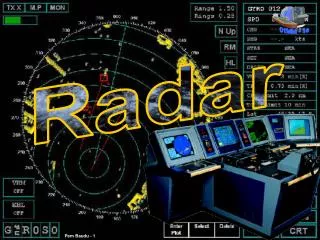
Radar Radar Range The range of the display is the distance from the centre of the screen to the top in nautical miles • The ranges available include 0.75 nm, 1.5 nm, 3 nm, 6 nm, 12 nm
Radar Radar Range 3 nm
Radar Heads Up vs North Up • Most RCM-SAR vessels do not have an accurate compass feed such as a gyro compass. • Therefore it is strongly recommended that the radar display is always set on Head Up mode • What is seen on the top of the radar is what is ahead • Bearings seen are relative to own vessel’s bow Heads Up v North Up
Radar Heads Up vs North Up
Radar Variable Range Marker (VRM) • The Variable Range Marker is using radar’s greatest accuracy - the measurement of range • The VRM is moved in or out, but measures most accurately when the outside of the VRM line touches the closest point of a target
Radar Variable Range Marker (VRM)
Radar Variable Range Marker (VRM) • If the object is beyond the radar horizon, such as a sloping foreshore there will be inaccuracies • • If you are travelling fast towards or directly away from the object you are ranging off, inaccuracies will be present • • Ranges on the beam will be more accurate
Radar Electronic Bearing Line (EBL) •The electronic bearing line (EBL) is a radial line extending from the origin (own ship) that can be set to any bearing •It can be used for ascertaining the relative bearing of a target. •When at speed, it has the greatest accuracy ahead and astern, and prone to the greatest errors on the beam
Radar Electronic Bearing Line (EBL)
Radar Range Rings • Range rings are equally spaced concentric circles • The distance between rings will generally be indicated as part of the range, e.g. 3 nautical miles range, 0.5 nautical miles between rings • They are used to quickly estimate the distance off of an echo
Radar Range Rings
Radar Collision Avoidance
Radar Relative Motion • When your vessel is moving, the image of the radar screen will be constantly changing as you move relative to the land and other vessels • Other vessel’s direction and speed are relative to your own course and speed • Objects that stand still on the radar screen are other vessels that match your speed and direction
Radar Relative Motion • Only when you are stopped will you be able to accurately determine another vessel’s true course and speed
Radar Risk of Collision • Use the electronic bearing line (EBL) to place over the target on the screen • If your vessels keep its course and speed, and the target comes down the EBL a risk of collision exists • The quicker a target come down the EBL, the sooner a close quarter situation will be
Radar Risk of Collision
Radar Risk of Collision • Therefore with this in mind, focus only on target movement that represents a risk of collision
Radar Collision Avoidance • Once a risk of collision is deemed to exist, the Collision Regulations then require you to understand whether you are the stand on or give way vessel, given the prevailing condition of visibility, AND other factors • These actions are not defined here.
Radar Effect of Change of Own Vessel Course and Speed •On a heads up display: •When your vessel turns, all of the objects on the display will rotate relative to you and will appear to move in the opposite direction •When your vessel changes speed,other boats will acquire a new motion relative to you. •If another boat changes direction or speed, the display will not change, only the relative motion of that boat
Radar Guard Zone • The VRM can also be used to set up a guard zone as an area around one’s own vessel into which we do not want another vessel to come
Radar Radar Navigation • The biggest skill with radar is to match what you see on the radar display with regards land and navigational aid targets, to that which is to be found on a navigational chart
Radar Radar Navigation
Radar Radar Navigation
Radar Radar Navigation • Navigational aids such as navigation buoys, and marks are often fitted with radar reflectors in order to make them more conspicuous • In certain cases important navigation buoys or mark will be fitted with Racons. These may encoded in morse code to identify them
Radar Radar Navigation Racon (B)
Radar Radar Navigation • Plotting by range alone can be used for sections of shoreline where you can clearly measure the range and then draw an arc at that radius
Radar Radar Navigation • An unstabilised radar is best used when using three ranges to fix your position. Fix
Radar Radar Navigation • Radar is providing first hand information and does not rely on outside electronics to work properly
Radar Radar Navigation •When plotting bearings from an unstabilised radar, use the formula MB = RB + MH MB = magnetic bearing RB = relative bearing MB = magnetic heading
Radar Radar Navigation •Where no other fixing method is off a radar is possible, plotting a range and bearing of a fixed isolated object can be used. •Navigation buoys are not considered fixed objects
Radar Radar Navigation • Radar can help you safely navigate along shorelines, and help stay a standard distance off during a shoreline search –Set the VRM at the minimum safe distance of approach
Radar Radar Navigation
Radar Radar Navigation with GPS • Radar navigation is complimented by the appropriate use of the Geographic Positioning System (GPS) • Radar and a GPS can communicate using the NMEA 0183 protocol • This is best achieved through the side by side displays on a chart plotter, where the radar picture can be easily compared with the electronic chart
Radar Radar Navigation with GPS
Radar Radar Reflectivity • •The strength of echoes are dependent on two features: • 1. Material reflectivity to radar signals • Metal and sheer rock races are good • Wood and foliage are poor
Radar Radar Reflectivity • 2. Aspect angle to the radar • Verticals are generally good • The greater the angle from the vertical, the poorer the signal • are poor
Radar Errors • False echoes are possible with radar • Almost all are connected with reflected signals
Radar Errors • Side Lobe effect • When a large vessel is close the side lobes of the radar transmission can cause some interference as shown
Radar Errors • Reflection from an overhead cable • The result from this is the echo gets returned off the cable. • As own vessel gets closer to the cable, the target appears to also get closer, to be on a collision course with position of collision where own vessel goes under the actual cable.
Radar Weather & Radar • The effect of rain can be reduced by the use of rain clutter, FTC or Rain controls • The effect of sea and swell waves can be reduced by use of sea clutter or STC • Excessive use of these controls can mask echoes • Practice of the use of these controls is important to achieve the appropriate level of masking for both STC and FTC
Radar Weather & Radar • Squall lines and rain can be seen on radar
Radar Weather & Radar • Wind and swell waves can be seen on radar, as can tide lines on occasion