Download
1 / 25
250 likes | 265 Vues
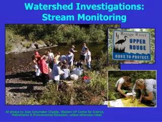
Find out who the certified SOS monitors are and what they do in the SML watershed. Explore the data from 17 stream sites monitored for ecological conditions in 2017. Discover the areas that had acceptable scores, areas with undetermined conditions, and areas with unacceptable scores.

E N D
They are regular SML folks who like to get into the water and find critters…
Summary 2017 SOS Data 17 stream sites monitored for ecological conditions: • 12 sites (71%) had acceptable scores (9-12) • compared to 8 sites in 2016 • 4 sites (24%) had a score of 8 where ecological conditions could not be determined • no change from the previous year • 1 site (5%) had an unacceptable scores (0 –7) • a decrease of 3 from the previous year
Gills Creek Area Notes • Jack O’Lantern – BOWA • In Booker T. Washington National Park • Impacted in 2009-2010 by Westlake development • Gills Creek – BOWA • In Booker T. Washington National Park • Gills Creek – Liberty Hall • Off Liberty Hall Road and bridge crossing Rt. 122 • Gills Creek – North Fork • Windy Gap area off Truman Road
Lower Blackwater Area Notes • Foul Ground Creek • Webster Road near Crafts Church Road, Glade Hill • Poplar Camp Creek • Ayers Road, Glade Hill
Upper Blackwater Area Notes • Blackwater – Riverbend • End of Riverbend Community off Rt. 220, Rocky Mount • Blackwater – Dillon’s Mill • Dugspur Road, Callaway • Blackwater – Webster Tributary • Bethany Road, Boones Mill • Currently monitor by DEQ
Hardy Road Area Notes • Indian Run • Hardy Road – 1 mile up from Booker T. Washington Highway • Grimes Creek • Wooded Acres development • Lynville Creek • North and west of clear cut area on Hardy Road • Not monitored since 2012 • Indian Creek • Westlake Golf Course
Boones Mill Area Notes • Maggodee Creek Rt. 220 • North of town • Maggodee Creek – Boones Mill Road • Near bridge on Boones Mill Road • Not monitored since 2014
Pigg River Area Notes • Pigg River – Waid Park, Rocky Mount • Near parking lot and bridge • Pigg River – Old Angle Farm • Rocky Mount area – not monitored since 2016 due to dam breach
Bedford Side of Lake Area Notes • Stoney Creek • Beechwood West Community • South Fork Hickory Creek • Hickory Creek Winery property • Spring fed • Jumping Run Creek • Goodview Road
Ferrum Area Notes • Ferrum Mountain Creek • Off Wiley Drive – lower Bassett Hall parking lot on Ferrum College Campus • Storey Creek • Across Route 40 from Ferrum College Campus • Nicholas Creek • Route 623 – 80 yds from bridge
Stream Monitoring Goals for 2018 • Train new monitors • Establish a firm data base for use in monitoring stability of watershed in face of pipeline construction