HEMS Tool Project History, Status and Future
230 likes | 462 Vues
HEMS Tool Project History, Status and Future . James H. Hartman FAA Aviation Weather Division, ANG-C6 Aviation Weather Research Program Ceiling and Visibility Program Lead December 18, 2013 v10. History. HEMS Tool - History. http:// weather.aero/tools/desktopapps/hemstool.

HEMS Tool Project History, Status and Future
E N D
Presentation Transcript
HEMS Tool Project History, Status and Future James H. Hartman FAA Aviation Weather Division, ANG-C6 Aviation Weather Research Program Ceiling and Visibility Program Lead December 18, 2013 v10
HEMS Tool - History http://weather.aero/tools/desktopapps/hemstool
HEMS Tool - History • Outcome of the 2006 HEMS Weather Summit • In order to address Controlled Flight Into Terrain (CFIT) and Loss Of Control (LOC) accidents, the Federal Aviation Administration (FAA) Part 135 Air Carrier Operations Branch (AFS-250), the HEMS industry, and the University Center for Atmospheric Research (UCAR) conducted a HEMS Weather Summit in early 2006. • The FAA’s Aviation Weather Division, ANG-C6, was not a member of the initial HEMS Weather Summit but the funding for the HEMS tool was absorbed into this office under research activities (AWRP).
HEMS Tool - History • 2006 HEMS Weather Summit conclusion: • Absence of usable C&V data between reporting and forecasting stations. Often, HEMS operators conduct entire HEMS flights in the area between such stations where no reporting exists • Commitment to provide HEMS operating community access to information which might support better weather decision making in Visual Flight Rules (VFR) operations • An ongoing R&D program could provide “gridded” ceiling and visibility assessment in areas between METAR/TAF reporting/forecasting sites • FAA (AFS-250) asked UCAR’s Research Applications Laboratory (RAL) to develop a weather display tool as a part of the Aviation Digital Data Service (ADDS) experimental web portal
HEMS Tool - History • New Helicopter Emergency Medical Service Weather Tool • FAA Aviation News, Jan/Feb 2007, Volume 46, Number 1 • AFS-250 was, and remains, the Office of Primary Responsibility (OPR) for HEMS • HEMS POCs • Roger Sultan, AFS-430 • Andy Pierce, AFS-250 • Richard Prosek, AFS-250
HEMS Tool - History www.weather.aero/hems HEMS Weather Display Tool became available 11/2006 on the ADDS Experimental web portal
HEMS Tool – Specified Use • FAA Notice N 8000.333 was released in conjunction with the use of the HEMS Tool: • Operators may not use this tool to support IFR operations; only approved use is in VFR operations and then only in the context of supporting a “no-go” decision • Operators may not use the HEMS Weather Tool as the sole source for decisions to “Go.” • Operators may only use established primary products, such as METARs, TAFs, area forecasts, weather depiction charts, prognosis charts, etc., to make both “Go” and “No-Go” decisions. • Since many primary products (such as area forecasts) do not have the specificity to identify highly localized low weather conditions, the HEMS tool can be helpful to resolve assessments at the 5km x 5km grid level.
HEMS Tool – Specified Use HEMS Certificate Holders may adopt the HEMS Weather Tool into their weather program if approved in their Operations Specifications by the FAA
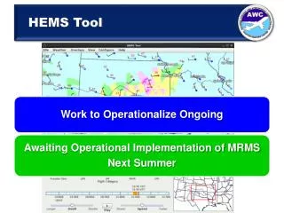
HEMS Tool Weather Data HEMS Tool overlays gridded weather on a base map • Model-based grids include: • Wind speed and direction • Temperature/Relative Humidity • Algorithmically-derived grids • Ceiling/visibility/flight category (CVA) • In-flight icing (CIP/FIP) • Plotted data and NWS products • METARs, PIREPS • TAFs, AIRMETs, SIGMETs • Radar (Base and Composite Reflectivity)
CVA Performance • Review and Assessment of CVA: • Technical Review Panel (TRP) Review (November 16, 2009) • Quality Assessment (QA) Report (November 30, 2010) • http://www.esrl.noaa.gov/fiqas/publications/articles/NCVA_D4_SUB_REGION_ENHANCEMENT_FINAL.pdf • Safety Risk Management (SRM) Assessment (August 9, 2011) • Review process concurred with operational release of CVA to NWS in 2012 under the following conditions: • Flight categories reduced from 5 to 3; IFR, VFR and Possible Terrain Obscuration only • Precautionary Use Statement with further explanation of CVA weaknesses on the Help Page
Precautionary Use Statement This product is for flight planning purposes only and should always be used in combination with C&V information from other aviation weather products such as METARs, AIRMETs, TAFs and Area Forecasts. CVA is intended to aid situational awareness with a quick-glance visualization of current C&V conditions across an area or along a route of flight. CVA derives C&V for areas between METAR stations so may, as a function of distance from a METAR, misrepresent actual conditions. See the Help Page for additional information on CVA use and limitations.
AWRP-sponsored HEMS Tool Enhancements • NCAR to upgrade the HEMS Tool with: • Improved base maps • C&V trending • User addition of specific location designators • Storage and retrieval of user preferences • HEMS Demonstration video • Upgrades bundled under Alpha and Beta releases • Alpha • Beta
Alpha Upgrades - Maps • Specific Location Designators • Users can specify icons for their chosen locations • Transition to MapServer • Additional information in base maps • More selective control of rendering base maps • Enhanced display capabilities • Colored elevation, shaded relief terrain, elevation contours
Alpha Upgrades - Weather • Ceiling and Visibility (C&V) Trending • Visualize past METAR-based C&V trends • Visualize TAF-based future ceiling and visibility trends
Beta Upgrades • Storage and Retrieval of User Preferences • User will have the ability to incorporate storage and retrieval preference functionality • Demonstration Video • Updated Demonstration Video that incorporates all upgrades completed in this SOW to the Experimental ADDS website • Proposed Strategy for Operational Transition • Proposed Strategy for Operational Transition of the C&V HEMS Viewer from the Experimental ADDS Website