Download
1 / 24
260 likes | 503 Vues
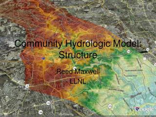
Adaptive Enhancements to PRMS for the National Hydrologic Model. Modeling of Watershed Systems . Lauren Hay Steve Markstrom Steve Regan Roland Viger Christian Ward-Garrison Shannon Poole. Precipitation Runoff Modeling System (PRMS).

E N D
Adaptive Enhancements to PRMS for the National Hydrologic Model Modeling of Watershed Systems Lauren Hay Steve Markstrom Steve Regan Roland Viger Christian Ward-Garrison Shannon Poole
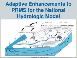
Precipitation Runoff Modeling System(PRMS) • Modular, deterministic, distributed-parameter, physical-process based model • Evaluate the hydrologic response of various combinations of climate, land use, topography, and hydrogeology.
Precipitation Evaporation Solar Radiation Air temperature Sublimation Plant Canopy Interception Evaporation & Transpiration Rain Rain Rain Snow Hortonian Runoff Snowmelt Snow Pack Impervious Reservoir Snowmelt Dunnian Runoff Soil Zone Upslope Surface Runoff and Interflow Interflow Streamflow and Lake Routing Recharge Upslope Groundwater Flow Groundwater Flow Groundwater Reservoir Groundwater source Groundwater Sink
Evaporation and Transpiration Hortonian Surface Runoff Throughfall, Snowmelt, and Upslope Hortonian Surface Runoff Dunnian Surface Runoff Depression Storage Impervious Preferential-Flow Reservoir Fast Interflow Upslope Dunnian Surface Runoff and Interflow Capillary Reservoir Gravity Reservoir Slow Interflow Direct Recharge Gravity Drainage
Input Enhancements • Political, economic, environmental and other changes can input to explore the impacts of policy decisions and other factors using scenario analysis. • Changes historic and projected include: • Urbanization • Agricultural and forestry practices • Fire • Flood • Drought • Growing and shifting populations • Climate • Biodiversity loss • Allow for any preprocessed, daily climate data by HRU • Growing season by HRU based • Dynamic parameters (any time step and location) • Dynamic water-use transfers (any time step and location) • Expand distributed parameterization
Other Enhancements • Stream and lake flow routing • Couple models • CSV output of simulations results
Input Climate by HRU • Any method of climate distribution to HRUs • Gridded data: e.g., Prism, DayMET, Mauer, RCM, GCM • Computed: e.g., XYZ • Data types • Precipitation • Minimum and maximum air temperature • Solar radiation • Potential ET • Active transpiration • Separate Input Files • Can be different time-series extent than Data File and each other, must include simulation time period • Any number of data types
Growing Season by HRU • Growing season defined between the average last killing frost (Spring) and first killing frost (Fall) dates • Computed: • Pre-process model mode for specified simulation time period and freezing temperature using USACE method • Any user-determined method
Dynamic Parameters Assess the impacts of historical, current, and projected land-use, climate, and ecological change • Any time step • Any HRU (full model domain to subsets) • Data types: • Impervious fraction and storage • Surface depression fraction and depth • Canopy type, density, and storage • Soil-zone storages • Active transpiration • Potential ET computation coefficients
Dynamic Parameters Time-series of land-surface characteristics • GIS interface • GDP • NHDPlus Vegetation Impervious Area Land Cover Terrain and Hydrology
Dynamic Water-Use Transfers • Any time step • Any HRU or stream segment • Sources: • Stream segment flow • Groundwater storage • Surface depression storage • Lake HRU storage • External • Destinations: • Sources • Consumptive use • Soil zone • Canopy Environment Canada, 2006
Dynamic Water-Use Transfers Agriculture is a major user of ground and surface water in the United States, accounting for approximately 80 percent of consumptive water use and over 90 percent in many Western States. Thermoelectric has highest surface water withdrawals, but, returns 98%, so only 3.3% of consumptive use. Residential consumptive use about 6.7% www.ers.usda.gov/topics/farm-practices-management/irrigation-water-use.aspx
Change in mean annual water use in Australia between 1983/84 and 1996/97 http://www.anra.gov.au/topics/water/pubs/national/water_use.html
Streamflow to consumptive use Streamflow to external location GW to crop field Lake storage to soil
Expand Distributed Parameterization • Required for characterizing and calibrating • Large models • Mixed resolution models Basin-wide, scalar and monthly parameters now specified for each HRU
Stream and Lake flow Routing • Streams • Muskingum • Replace outflow • Lakes • Fraction of HRU as surface depression storage • Modified Puls • Linear • Flow through • Replace outflow • Broad-crested weir(seepage to and discharge from GW storage) • Gate-opening time series (seepage to and discharge from GW storage)
Couple Models • Loosely couple to any model to allow easy support and comparison to other hydrologic analysis and models • Input climate model results by HRU • Map simulation results to target model • Spatial resolution of target model • Selected time intervals • Warm-up years • Weekly • Monthly • Yearly • Total simulation time period
Current Climate Downscaled Climate from GCMs Precipitation, Maximum Temperature, Minimum Temperature Precipitation, Maximum Temperature, Minimum Temperature Current Landcover Future Landcover Watershed Model Precipitation, Maximum and Minimum Temperature, Surface, Subsurface, and Groundwater Flow Linked models Data sources Diverse spatial scales Stream Temperature Model Precipitation, Maximum and Minimum Temperature, Flow Biostats, Stream Temperature Aquatic Occupancy Model
CSV output of Simulation Results • Variables: • Basin area-weighted states and fluxes • Total storages • Water Balance of reservoirs • Segment outflow • Measured streamflow • Analysis using: • Excel • R scripts