Improved SST Analysis
Improved SST Analysis. Xu Li, John Derber NCEP/EMC. Project Objective: To Improve SST Analysis. Use satellite data more effectively Resolve SST diurnal variation. Progress (1) SST Retrieval. Develop a physical (variational) SST retrieval algorithm

Improved SST Analysis
E N D
Presentation Transcript
Improved SST Analysis Xu Li, John Derber NCEP/EMC
Project Objective:To Improve SSTAnalysis • Use satellite data more effectively • Resolve SST diurnal variation
Progress (1)SST Retrieval • Develop a physical (variational) SST retrieval algorithm • Demonstrate the potential of variational assimilation of satellite radiance to derive SST • Done with AVHRR and used in NCEP operational 1/12 RTG daily SST analysis • Other satellites?
OPERATIONS: • New daily Real-time global SST (RTG_SST_HR) analysis (1/12o latitude, longitude resolution) is generated every 24-h (22:30 UTC) using latest 24 h of real-time data.(implemented – September 27, 2005) • Original daily Real-time global SST (RTG_SST) analysis (1/2ºlatitude, longitude resolution) is generated every 24-h (22:30 UTC) using latest 24 h of real-time data.(implemented – January 30, 2001).Still running in parallel. • SST derived as physical retrievals from AVHRR data (JCSDA) • .Used as the lower boundary condition over the oceans for the Eta/WRF regional forecast model. • Areal maps and time series of validation statistics are available immediately from the MMAB WEB page: • Under evaluation by international forecast centers (ECMWF, UK Met Office)
Daily Analysis Difference RTG_SST-HR Operational Reduced daily noise
Smoother anomalies (less noise) Smoother anomalies (less noise)
Comparison between Two SST Retrieval Algorithms , , , Here For AVHRR
Progress (2)Direct Assimilation ofSatellite Radiance • Analyze SST by assimilating satellite radiances directly with GSI • 6-hourly skin temperature analysis (Exps. Done) • Impact of the errors of the first guess and in situ observations on SST analysis (Exps. Done) • The use of AVHRR GAC 1-b data (Done) • Aerosol Effect • Radiance increment dependency on Navy aerosol optical depth (Done) • Bias correction? • Incorporation of oceanic components in GSI • Flux files (done) • Diurnal warming and sublayer cooling model (in development) • Oceanic model in GFS and coupling?
The use of AVHRR GAC 1-b data in GSI (For GAC) No thinning for Navy
Satellite Radiance dependency on Aerosol Optical Depth(Not significant, the same to HIRS, AMSU)
Progress (3):Resolve Diurnal Variation • Active ocean to improve the first guess • Ideally: 3-dimensional OGCM (resolving diurnal variation?) • Near future: High resolution 1-dimensional model (PWP, turbulence) • At present (in development, Ilya Rivin, Carlos Lozano): • Analysis Variable: Foundation SST (converted into skin and sub-skin SST) • Low resolution mixed layer model (2 layers) + Diurnal Warming model (Fairall et al, 1996) + Skin layer cooling model (Fairall et al, 1996) • Inventory on the depths of buoys and ships (Done)
Impact of strong diurnal variation (weak winds) on the validation of SST retrieval and analysis All: All match-up. Hwind: Match-up with 10m wind > 4.5 m/s Nall: Number of all match-up NHwind: Number of match-up with 10m wind > 4.5 m/s
Depths of Buoys and Ships • Mooring Buoys • TAO: 1.0 m. • Station ID list and status: http://www.pmel.noaa.gov/tao/proj_over/wmo.html • TRITON: 1.5 m • Station ID list and status:http://www.pmel.noaa.gov/tao/proj_over/wmo.html • PIRATA: 1.0 m. Station ID list and status: http://www.pmel.noaa.gov/tao/proj_over/wmo.html • Indian Ocean: 1.0m. Station ID list and status: http://www.pmel.noaa.gov/tao/proj_over/wmo.html • NDBC: 0.6 m (3 meter discus buoy) or 1.0 m (others). Station ID list and status: http://seaboard.ndbc.noaa.gov/stndesc.shtml • Canadian: 0.6 m (3-meter discus buoy) or 1.0 m (6, 10 or 12-meter discus buoy), unknown yet (WKB, 0100-7, 02 02). Station ID list and status: http://shylock.pyr.ec.gc.ca/~wbs/bplatstat.html • COMPS: 1.2m. Station ID list and status: http://seaboard.ndbc.noaa.gov/to_station.html • GoMOOS: 1.0m. Station ID list and status: http://seaboard.ndbc.noaa.gov/to_station.html • Irish: 1.0m. Station ID list and status: http://seaboard.ndbc.noaa.gov/to_station.html
MBARI: 0.6m. Station ID list and status: http://seaboard.ndbc.noaa.gov/to_station.html • Meteo France: 1.0m. Station ID list and status: http://seaboard.ndbc.noaa.gov/to_station.html • MySound: 1.0m. Station ID list and status: http://seaboard.ndbc.noaa.gov/to_station.html • Scripps: 0.45 m. Station ID list and status: http://seaboard.ndbc.noaa.gov/to_station.html • UK: 1.0m. Station ID list and status: http://seaboard.ndbc.noaa.gov/to_station.html • Drifting Buoys • In a still wind condition, the sea water temperature at 12.5 cm ~ 17.5 cm depth is observed. The drifter may go below the water more than one meter when there is large wave, which is related to strong surface wind. • The drifting buoy station ID: http://www.aoml.noaa.gov/phod/dac/deployed.html
Ships: • The ships information: http://www.wmo.ch/web/www/ois/pub47/pub47-home.htm, including the record layout, code table of data file and the list of VOS. • The methods of obtaining SST • BTT: Bait tanks thermometer • BU: Bucket thermometer (1.0 m) • C: thermometer in condenser intake on steam ships, or inlet engine cooling system on motor ships (2 ~ 14.5 m) • HC: Hull contact sensor (1.4 ~ 7.3m) • HT: “Through hull” sensor • RAD: Radiation thermometer • TT: Trailing thermistor • OT: Other • There may be two methods of measuring sea temperature on a ship
Future • Analysis with GSI • More satellite data • AVHRR, HIRS, AIRS, AMSRE, GOES and other geostationary satellites, others • Observation errors for in situ data • First guess error • The sensitivity of skin and sub-skin temperature to foundation temperature (related by heat flux) • Active ocean in GFS/GSI • The impact of diurnal warming and sub-layer cooling on the satellite radiance simulation • A low resolution mixed layer prediction model • Improvements to Fairall warming model • A high resolution one-dimensional oceanic model?! • Couple Analysis
Cool skin/warm layer component of the COARE 3.0 bulk flux algorithm (Fairall et al., 1996) • Based on Price, Weller, and Pinkel • 2nd moment closure turbulent mixed layer model with added skin layer (Wick, 1995) • Based on Kantha and Clayson (1994)
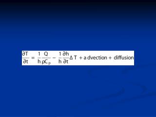
Assumed vertical temperature profile: Linear or Exponent? z Strong warming z Weak warming Integrate this T equation along t and z when is assumed, under the condition of positive downward surface heat flux
Warming when wind vanishes The diurnal warming (trapping) depth: When wind is zero, . Therefore, The scaling must change over to a different form, governed by free convection and radiation absorptin. The mixing depth is then the convection depth C (Dalu and Purini, 1981, and J Price et al , 1986). The warming depth is deeper than the mixing depth in this situation.
Air-sea mass exchange and Warming Depth The notion behind PWP model is that the wind mixing occurs primarily to relieve shear flow instability. The stability limit is given by a Richardson number criterion as follows: Assuming a relation this is true between the density and velocity anomalies and the length scale, then, In Fairall et al, the mass exchange, caused by precipitation (P) and evaporation (E) between air and sea is not included, therefore When salinity is accounted, then This gives a slightly different warming depth:
Physical/Variational SST Retrieval Formulation Cost Function: is brightness temperature (radiance), skin temperature, atmospheric temperature vertical profile and atmospheric water vapor vertical profile respectively. is calculated with radiative transfer model. is the sensitivity of to respectively. Initially, the and are assumed not varying with height (z). Therefore, The sum of these sensitivities with height is used in the scheme for AVHRR data. Upper-subscription represents analysis, first guess and observation respectively. Lower-subscription means the channel index. is the error variance of and respectively The solutions of are solved by minimizing cost function J
Bias & RMS of SST retrievals and analysis to buoy RTPH: Physical Retrieval; RTNV: Navy Retrieval; ANPH: Analysis with RTPH; ANNV: Analysis with RTNV; NOBS: Number of match-up in 6-hour time window Solid: RMS; Dashed: Bias