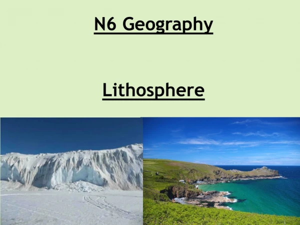
Lithosphere
Lithosphere. Glaciation. Lithosphere. Glaciation. LANDFORMS. LANDFORMS. Question may involve a given list of erosional and depositional glacial features based on a block diagram. One feature from each list must be chosen.

Lithosphere
E N D
Presentation Transcript
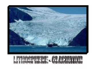
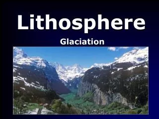
Lithosphere Glaciation
Lithosphere Glaciation LANDFORMS LANDFORMS Question may involve a given list of erosional and depositional glacial features based on a block diagram. One feature from each list must be chosen. Alternatively, glacial mapping questions often require a feature to be selected and explained. • Annotated diagrams must be used if appropriate. • Usually six marks apiece. • Diagrams support your text , not vice versa.
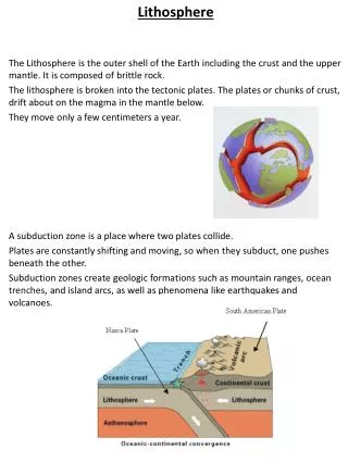
Lithosphere Glaciation Erosional features CORRIE LANDFORMS A cirque is an amphitheatre-like valley, or valley head, formed at the head of a glacier by erosion. A cirque is also known as a cwm in Wales, a coomb in England, and a corrie in Scotland and Ireland. Cirques form in conditions which are favourable; which in the northern hemisphere includes the north-east slope being in shade and away from prevailing winds. These areas are sheltered from heat, and so, they encourage the accumulation of snow. If the accumulation of snow increases, the snow transforms into glacial ice. The process of nivation follows (where a hollow in a slope may be enlarged by freeze-thaw weathering and glacial erosion). Eventually, this hollow can become big enough so that glacial erosion intensifies. Debris (or till) in the ice may also abrade (glacial abrasion) the bed surface; should ice move down a slope it would have a ‘sandpaper effect’ on the bedrock beneath on which it scrapes. Eventually, the hollow can become a large bowl shape in the side of the mountain, with the headwall being weathered by constant freezing and thawing, and eroded by plucking. The basin will become deeper if it continues to become eroded by abrasion. Should plucking and abrasion continue, the dimensions of the cirque will increase, but the proportion of the landform would remain roughly the same.
Lithosphere Glaciation Erosional features EROSIONAL FEATURES CORRIE LANDFORMS Snow collects in depressions on shaded north facing mountainsides. During an Ice Age this does not melt, so layers of snow build up in the hollow over the duration if the glacial. Multiple layers of snowarecompressedinto ice,called neve. The build up of ice mass eventually causes it to slowly moves downhill under gravity. As it moves over the rock it plucks(freezes onto and pulls out) rock from the mountain and uses these to further abrade with on its journey. Frost shattering also adds erosive material to the ice, as chips of rock fall from the backwall are become embedded in the ice. The action of plucking/abrasion and the frost shattering combine to steepen the back wall and sides
Lithosphere Glaciation Erosional features EROSIONAL FEATURES CORRIE LANDFORMS Some of the debris can also be dragged along the base of the glacier, deepening the floor of the hollow by abrasion. The mountain itself resists this erosion, forcing the ice upwards. This causes the glacier to rotate in a circular path (rotational slip), deepening and gouging the hollow further. Rate of erosion decreases at edge of corrie as the ice is less thick here, leaving a lip. The lip acts as a dam, trapping precipitation. Over time tarns - small lakes - develop. Deep, bowl shaped hollow with a steep backwall and sides
Lithosphere Glaciation Erosional features EROSIONAL FEATURES ARETE LANDFORMS An arête is a thin, almost knife-like, ridge of rock which is typically formed when two glaciers erode parallel U shaped valleys. The arête is a thin ridge of rock that is left separating the two valleys. Arêtes can also form when two glacial cirques erode headwards towards one another, although frequently this results in a saddle-shaped pass, called a col. The edge is then sharpened by freeze-thaw weathering The word "arête" is actually French for fishbone; similar features in the Alps are described with the German equivalent term Grat or Kamm (comb).
Lithosphere Glaciation Erosional features EROSIONAL FEATURES ARETE LANDFORMS A narrow, rocky, steep-sided ridge where two corries have formed back-to-back. As the steep backwalls of the two corries move towards each other, the dividing rock becomes narrower, creating an arête.
Lithosphere Glaciation Erosional features PYRAMIDAL PEAK A pyramidal peak, or sometimes in its most extreme form called a glacial horn, is a mountaintop that has been modified by the action of ice during glaciation and frost weathering. If the use is unambiguous within a mountain context, then the simple terms peak or horn may be used.
Lithosphere Glaciation Erosional features PYRAMIDAL PEAK Pyramidal peaks develop when corries erode backwards or sideways towards each other on all sides of a mountain. Aretes and pyramidal peaks are secondary landforms of corries so some mention of the processes involved in the formation of corries is necessary. This results in a jagged, pyramid-shaped mountain with several radiating arêtes.
Lithosphere Glaciation Erosional features U-SHAPED VALLEY/GLACIAL TROUGH A valley carved by glaciers, or glacial valley, is normally U-shaped. If we can see the valley, it means the glacier that formed it is no longer there. When the ice recedes or thaws, the valley remains, often littered with small boulders that were transported within the ice. Floor gradient does not affect the valley's shape, it is the glacier's size that does. Continuously flowing glaciers - especially in the ice age - and large sized glaciers carve wide, deep incised valleys. Examples of U-shaped valleys are found in every mountainous region that has experienced glaciation, usually during the Pleistocene ice ages. Most present U-shaped valleys started as V-shaped before glaciation. The glaciers carved it out wider and deeper, simultaneously changing the shape. This proceeds through the glacial erosion processes of glaciation and abrasion, which results in large rocky material (glacial till) being carried in the glacier. A material called boulder clay is deposited on the floor of the valley. As the ice melts and retreats, the valley is left with very steep sides and a wide, flat floor. A river or stream may remain in the valley. This replaces the original stream or river and is known as a misfit stream because it is smaller than one would expect given the size of its valley.
Lithosphere Glaciation Erosional features U-SHAPED VALLEY/GLACIAL TROUGH Before glaciation the valley has a V-shape cross-section. During glaciation, glaciers grow out from corries and occupy valleys. They take the easiest path down the valley, following the original stream. Powerful glaciers increase erosion processes but but unlike streams, glaciers focus their grinding energy on the insides of bends. Bit by bit, the glacier eats away at the meandering curves of the original stream valley, carving a wider, straighter valley . Frost-shattering, plucking, abrasion occur on valley sides, making then steeper, and on the floor making it flatter and wider. Interlocking spurs are truncated (cut-off). Tributary valleys are left hanging above the main valley. Post-glacial valley has a U-shaped cross section.
Lithosphere Glaciation Erosional features HANGING VALLEYS A hanging valley is a tributary valley with the floor at a higher relief than the main channel into which it flows. They are most commonly associated with U-shaped valleys when a tributary glacier flows into a glacier of larger volume. The main glacier erodes a deep U-shaped valley with nearly vertical sides while the tributary glacier, with a smaller volume of ice, makes a shallower U-shaped valley. Since the surfaces of the glaciers were originally at the same elevation, the shallower valley appears to be ‘hanging’ above the main valley. Often, waterfalls form at or near the outlet of the upper valley.
Lithosphere Glaciation Erosional features HANGING VALLEYS Pre-glaciation, tributary valleys slope gently into main valley. During glaciation, smaller tributary valleys held smaller, less powerful glaciers and so is eroded less than the main valley. Main valley glaciers truncated interlocking spurs in the tributary valleys, leaving the valleys that run between the spurs hanging high above the main valley. Streams flowing over the edge of hanging valleys now form waterfalls over the steep gradient and the tributary valley is left high above the main valley.
Lithosphere Glaciation Erosional features RIBBON LAKE A ribbon lake is a long and narrow, finger-shaped lake, usually found in a glacial trough. Its formation begins when a glacier moves over an area containing alternate bands of hard and soft bedrock. The sharp-edged boulders carried at the bottom of the glacier erode the softer rock more quickly by abrasion, thus creating a hollow called a rock basin. On either side of the rock basin, the more resistant rock is eroded less and these outcrops of harder rock are known as rock bars, which act as dams between which rainwater may accumulate after the retreat of the ice age, filling up the rock basin and creating a ribbon lake. A ribbon lake may also form behind a terminal or recessional moraine, both of which also act as dams, enabling water to accumulate behind them. A ribbon lake may also occur if a tributary glacier joins a main glacier. The increase in power can create a trough, which is filled with water from a river/meltwater to create a ribbon lake.
Lithosphere Glaciation Erosional features RIBBON LAKE During glaciation differential erosion i.e. uneven erosion of the valley floor leads to some parts of the valley floor being deepened more than elsewhere. This is due to sections of less resistant, softer rock or tributary glaciers adding ice and therefore increasing erosional power at specific points. Post-glacial depressions are infilled by meltwater and precipitation. Long, narrow lake occupying floor of a glaciated valley often with a misfir stream flowing inot and out of the lake.
Lithosphere Glaciation Erosional features SCREE SLOPES The term scree is generally used interchangeably with talus, though scree often refers to rocks that are small (e.g., smaller than a human head), while talus can refer to rocks larger than scree. The formation of scree is often a result of frost heaving or shattering, one of the physical weathering processes that slowly wear mountains down. During the day, water can flow into cracks and crevices in the rock. If the temperature drops sufficiently, for example with the onset of evening, the water freezes. Since water expands when it freezes, it forms a powerful wedge which can eventually break out pieces of rock. A repeated cycle of freeze-thaw can lead to significant erosion and most of the loose rock or scree slopes so common in the mountains have been formed in this way.
Lithosphere Glaciation Erosional features SCREE SLOPES Scree is a collection of debris found at the base of slopes formed by frost shattering. Water enters cracks and joints in rock. As the temperature drops the water freezes and this causes the water to expand. Over time, this continual enlargement process widens cracks and joints, allowing more water to enter. Eventually, rock fragments break off as scree and fall to the base of the slope, under gravity, where they accumulate to form scree slopes. This is the start of the process of soil formation.
Lithosphere Glaciation Depositional features TERMINAL MORAINE A terminal moraine, also called end moraine, is a moraine that forms at the end of a glacier. Terminal moraines mark the maximum advance of the glacier. An end moraine is at the present boundary of the glacier. Terminal moraines are created at the edge of the greatest extent of the glacier. At this point, the debris that has been pushed by the front edge of the ice is driven no farther, but instead is dumped in a heap. Because the glacier acts very much like a conveyor belt, the longer it stays in one place, the greater the amount of material that will be deposited. The moraine is left as the marking point of the terminal extent of the ice.
Lithosphere Glaciation Depositional features TERMINAL MORAINE During glaciation a glacier moves down valley accumulating moraine (debris) by abrasion. Moraine is “bulldozed” at snout (front)of glacier. As glacier moves into lower, warmer areas the snout of the glacier begins to melt and the glacier recedes. The moraine is deposited as a high ridge of unsorted material across the valley floor. The terminal moraine therefore marks the maximum extent of the glacier’s advance.
Lithosphere Glaciation Depositional features ESKERS An Esker is a long, winding ridge of stratifiedsand and gravel. Eskers are frequently several miles in length and, because of their peculiar uniform shape, somewhat resemble railroadembankments. Most eskers are believed to form in ice-walled tunnels by streams which flowed within and under glaciers. After the retaining ice walls melt away, stream deposits remain as long winding ridges. Eskers may also form above glaciers by accumulation of sediment in supraglacial channels, in crevasses. Eskers form near the terminal zone of glaciers, where the ice is not moving as fast and is relatively thin. The rate of plastic flow and melting of the basal ice determines the size and shape of the subglacial tunnel. This in turn determines the shape, composition and structure of an esker. Eskers may exist as a single channel, or may be part of a branching system with tributary eskers. They are not often found as continuous ridges, but have gaps that separate the winding segments. The ridge crests of eskers are not usually level for very long, and are generally knobby. Eskers may be broad-crested or sharp-crested with steep sides. They can reach hundreds of kilometres in length. The concentration of rock debris in the ice and the rate at which sediment is delivered to the tunnel by melting and from upstream transport determines the amount of sediment in an esker. The sediment generally consists of coarse-grained, water-laid sand and gravel. This sediment is stratified and sorted, and usually consists of pebble/cobble-sized material with occasional boulders.
Lithosphere Glaciation Depositional features ESKERS Eskers are long, narrow winding ridge of moraine on glaciated valley floor. They are created by sub-glacial streams i.e. streams flowing under glaciers and sometimes by supraglacial streams flowing in crevasses. Sub-glacial streams develop as abrasion on the valley floor creates friction and heat which melts sections of ice allowing streams to flow. These streams, loaded with moraine, are held in place by surrounding ice. They deposit this moraines as any stream would. Post-glaciation, the deposited moraine follows the same course as the sub-glacial stream.
Lithosphere Glaciation Depositional features OUTWASH PLAIN Outwash plains are found in glaciated areas. Glaciers and icecaps contain large amounts of silt and sediment, picked up as they erode the underlying rocks as they move slowly downhill, and at the snout of the glacier, meltwater can carry this sediment away from the glacier and deposit it on a broad plain. The material in the outwash plain is often size-sorted by the water runoff of the melting glacier with the finest materials, like silt, being the most distantly re-deposited, whereas larger boulders are the closest to the original terminus of the glacier. An outwash plain might contain surface meandering streams that rework the original deposits.
Lithosphere Glaciation Depositional features OUTWASH PLAIN The outwash plain as an area of flat land composed of gravels, sands and clays. Meltwater streams flow out from the glacier as it recedes (melts), carrying outwash materials with them. These streams deposit outwash materials in stratified (sorted) layers. Gravels, being the heaviest material, are deposited first, followed by sands and finally clays to create the outwash plain. The outwash plain as beyond terminal moraine and has not been covered by the glacier.
Lithosphere Glaciation Glacial mapping “The landscape of the area shown on the map extract has been greatly affected by glacial erosion” Describe the evidence to support the above statement, with reference to specific named features of glacial erosion shown on the map extract. The question refers toglacial erosion only. Map evidencemust be providedfor full marks.
Lithosphere Glaciation Glacial mapping CORRIES Very close contour pattern on three sides indicating precipitous corrie back wall and sides. Roughly semi-circular shape. Distinctive tarn water feature, often with stream running from it. Place names - Coire (Scotland), Cwm (Wales), Cirque, Cove (England)
Lithosphere Glaciation Glacial mapping CORRIES Very close contour pattern on three sides indicating precipitous corrie back wall and sides. Roughly semi-circular shape. Distinctive tarn water feature, often with stream running from it. Place names - Coire (Scotland), Cwm (Wales), Cirque, Cove (England)
Lithosphere Glaciation Glacial mapping ARETES Locate two adjacent corries - ridge between is an arête. Aretes usually indicated by the cliff/outcrop symbol. Sometimes have a footpath along them. Place names e.g. Striding Edge.
Lithosphere Glaciation Glacial mapping ARETES Locate two adjacent corries - ridge between is an arête. Aretes usually indicated by the cliff/outcrop symbol. Sometimes have a footpath along them. Place names e.g. Striding Edge.
Lithosphere Glaciation Glacial mapping PYRAMIDAL PEAKS Focal point of multiple corries. Cliff/outcrop symbol indicating highly eroded, jagged nature. Highest point - usually highlighted by triangulation pillar.
Lithosphere Glaciation Glacial mapping PYRAMIDAL PEAKS Focal point of multiple corries. Cliff/outcrop symbol indicating highly eroded, jagged nature. Highest point - usually highlighted by triangulation pillar.
Lithosphere Glaciation Glacial mapping U-SHAPED VALLEY Usually reasonably straight valley. Flat valley floor shown by absence of contour lines. Close contour pattern on valley sides indicating steep slopes.
Lithosphere Glaciation Glacial mapping U-SHAPED VALLEY Usually reasonably straight valley. Flat valley floor shown by absence of contour lines. Close contour pattern on valley sides indicating steep slopes.
Lithosphere Glaciation Glacial mapping HANGING VALLEY Tributary valley entering main valley - little or no V-shape contours. Waterfalls shown by tributary streams flowing down steep valley sides.
Lithosphere Glaciation Glacial mapping RIBBON LAKE Long, narrow water feature on floor of U-shaped valley. SCREE Shown by dots - under “rock features” in the map’s key.