Download
1 / 73
730 likes | 925 Vues
Explore the coastal landscapes of the UK, learn about erosion processes, wave formations, and differentiating constructive and destructive waves.

E N D
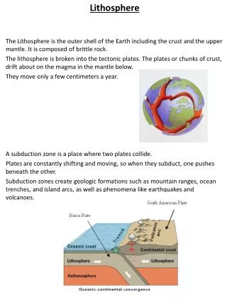
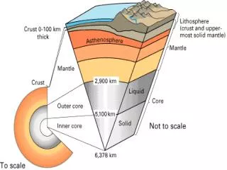
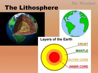
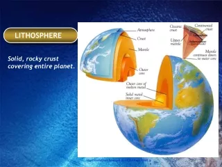
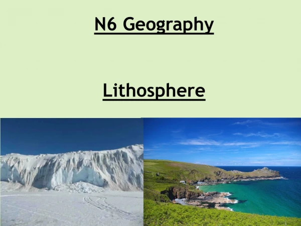
N6 Geography Lithosphere
We are learning to… • Describe the location of coastal areas and features in the UK • Differentiate between constructive and destructive waves • Describe how the coastline is shaped by waves
I can… • Locate areas with coastal landscapes on a map • Draw a diagram showing how waves erode the landscape • Explain the processes of erosion used by waves to shape the landscape
A New Ocean: http://www.bbc.co.uk/programmes/p00fzssy Waves Explained: http://www.bbc.co.uk/programmes/p00gbgc5
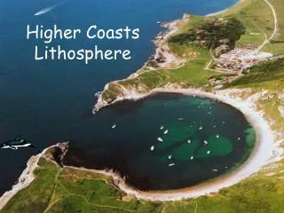
The British Isles has a coastline which amounts to 19,491 miles! Name the coastal areas and features!
A – outer hebridese • B – Inner hebridese • C – North channel • D – Irish sea • E – Cardigan Bay • F – St George’s Channel • G – Bristol Channel • H – Str of Dover • J – North sea
Coastal Erosion Processes of Erosion at the Coastline1. Hydraulic Action: Waves crash against a cliff and drive water under great pressure into cracks in the rock. This pressure squeezes the air and as the wave falls back the air expands explosively, loosening pieces of rock. 2. Corrasion: Corrasion (or abrasion) occurs when stones and pebbles are picked up by waves and thrown against the cliff, causing erosion.
3. Solution: Salty sea water chemically dissolves rocks. This is most noticeable on chalk and limestone cliffs. 4. Attrition: Rock fragments (stones and pebbles) hit against each other and so are reduced in size.
Coastal landscapes are formed by a combination of erosion, transportation and deposition processes. Waves The force of the sea changes the coastal landscape. Waves get their energy from the wind. The size of the wave is determined by: • The speed of the wind • The length of time the wind has been blowing • The distance of sea it has travelled over (the fetch) • The stronger the wave, the more erosion it will cause.
2) Water is shallower closer to the coast. Friction with the sea bed slows movement at the base of the circular movement of water. Top of wave continues to move forward. Wave height and steepness increases. 1) Deep Water: water moves in a circular motion producing the wave form. 3) Wave breaks. Water plunges forward as swash. Water returns as backwash.
Tides At high tide the water will be deepest offshore and larger waves with more energy can reach the beach or cliff. Storm winds at high tide have the most energy and they are responsible for most erosion and transportation. Tidal range is the difference in the height of the sea between high tide and low tide.
Constructive Waves They are created in calm weather and are less powerful than destructive waves. They break on the shore and deposit material, building up beaches. They have a swash that is stronger than the backwash. They have a long wavelength, and are low in height.
Destructive Waves Destructive waves are created in storm conditions. They are created from big, strong waves when the wind is powerful and has been blowing for a long time. They occur when wave energy is high and the wave has travelled over a long fetch. They tend to erode the coast. They have a stronger backwash than swash. They have a short wave length and are high and steep.
Task 1 Complete the blank map of the UK by labelling the coastal areas. Copy the diagram which shows the features of a wave. Explain the difference between a constructive and a destructive wave. Explain the processes of erosion.
We were learning to… • Describe the location of coastal areas and features in the UK • Differentiate between constructive and destructive waves • Describe how the coastline is shaped by waves
Can I… • Locate areas with coastal landscapes on a map • Draw a diagram showing how waves erode the landscape • Explain the processes of erosion used by waves to shape the landscape
We are learning to… • Describe the formation of headlands and bays • Describe the formation of caves, arches, stacks and stumps
I can… • Explain the processes involved in the formation of a headland and bay with the aid of a diagram • Explain the processes involved in the formation of caves, arches, stacks and stumps with the aid of a diagram
Headlands and Bays can form where rocks outcrop at 900 to the coast 2. Here there are alternate bands of resistant and less resistant rock 3. Where there is soft rock (e.g. clay), erosion is rapid - and bays are formed (indent in coastline) 4. Where there is more resistant rock (e.g. chalk), erosion is much slower - headlands are formed as the harder rock is left sticking out into the sea 5. Exposed headlands then become vulnerable to destructive waves but help to shelter neighbouring bays.https://www.youtube.com/watch?v=ZWEJq03NBao
All rocks have lines of weakness. The sea and its waves use hydraulic action, abrasion, attrition and solution to erode along any lines of weakness. Undercutting takes place all around the headland. • These lines of weakness get enlarged and develop into small sea caves. • The caves are deepened and widened on both sides of the headland until eventually the sea cuts through the headland, forming an arch. • The rock at the top of the arch becomes unsupported as the arch is enlarged, eventually collapsing to form a stack. • The stack gets eroded until only a stump remains. • Over time the stump will disappear. • As the headland retreats under this erosion, the gently sloping land at the foot of the retreating cliff is called a wave-cut platform.
Examples – Old man of Hoy Selwicks Bay, Flamborough
Task 2 – Exam style question With the aid of a diagram, describe the formation of headlands and bays. (8) With the aid of a diagram, describe the formation of caves, arches, stacks and stumps. (8)
Perfect answer Erosional processes: Erosion takes place due to hydraulic action — pounding waves compress trapped air in the rocks, creating an explosive blast which weakens and loosens rock fragments. Abrasion/corrasion — rock fragments thrown against the headland create a sandblasting (abrasive) action, wearing away the rock. Solution/corrosion — carbonic acid in sea water weathering limestone and chalk. Attrition — rock fragments slowly being ground down by friction from wave action into smaller and rounder pieces to form sand.
Perfect answer Headland and bay: Formed by differential erosion, where softer, less resistant rocks erodes more quickly than harder, resistant rocks. A headland is an area of hard rock which juts out into the sea and a bay is a sheltered area of softer rock between headlands. Often form in areas with a discordant coastline where alternate bands of rock are found at right angles to the coast. Constructive waves build a small beach in the sheltered bay between the headlands.
1) Weather weakens the top of the cliff – rain saturating the soil / permeable rock. 2) The sea attacks any joints crack or faults in the base of the cliff through the processes of hydraulic action and abrasion (explain) forming a wave-cut notch. 3) The notch increases in size leaving the cliff overhanging and unsupported, eventually causing the cliff to collapse due to the weight above. 4) The backwash carries the rubble towards the sea forming a wave-cut platform which is a gently sloping rocky surface extending out to sea away from the cliff. 5) The cliff retreats inland due to this continued process of the cliff being eroded.
Task 3 – Exam style question With the aid of a diagram, describe the formation of a wave cut platform. (8)
Perfect answer Wave-cut platform: weaknesses such as joints, faults or cracks in cliffs are undercut by erosion to form a wave-cut notch the rock above overhangs over the notch and, as erosion continues, the notch enlarges until the unsupported overhang collapses due to the weight the new cliff face is then eroded and through time, the cliff retreats inland, leaving a gently-sloping rocky surface called a wave-cut platform, which extends out to sea away from the cliff the platform is abraded by rock materials, with rock pools and pot holes forming, evident at low tide
Processes of Transportation Sediments are moved up and down the beach (swash and backwash). Sediments are moved along the beach by longshore drift.
Backwash: As the wave loses its momentum, energy is transferred back to the sea – this return flow is called backwash. Swash: The water which rushes up the beach is called swash.
Long Shore Drift Long Shore Drift is caused by coastal transportation and deposition where material is moved along a coastline by waves. Waves often approach the coast at an angle carrying material with them. The swash carries material onto the beach. When the backwash drags material out to sea, it travels at right angles to the beach down the steepest gradient. This movement will gradually transport material laterally along the coast.
Bars and Tombolos A bar is a ridge of sand that blocks off a bay or river mouth.A lagoon is created behind the bar in a bay where there is no river.A tombolo is a bar of deposited material linking the mainland to an island.
Landforms of Deposition Depositional features produced by longshore drift include spits, bars and tombolos.
The diagram shows the building of a spit by longshore drift across the mouth of a river. Sandspits often have a curved or hooked end as a secondary wind and wave direction curves the end of the spit as waves strike from this second and different direction. A series of such hooks can develop over time. The spit creates an area of calmer water, sheltered by the spit. A lagoon, salt marsh and finally dry land can develop in this sheltered area.
Spits 1) Longshore drift moves large amounts of material along the beach until there is a sudden change in the direction of the coastline. The sand keeps on moving in the original direction, even though there is not a coastline to follow. 2) The sea has to be relatively shallow and sheltered allowing the accumulation of sand usually beyond a headland. 3) Sometimes a curve develops if the on- shore wind changes direction. 4) Spits can become permanent if the prevailing wind picks up sand and blows it inland forming sand dunes.
Bars and Lagoons • A bar is a barrier of sand stretching right across a sheltered bay. • It usually stretches across the bay due to the absence of any large river that might wash it away. • It can cut off a lagoon to the landward side. • A lagoon is a body of brackish water- part salty, and part fresh. It often supports specialised plants and animals, and is protected as a nature reserve.
Tombolo If a bar links up with an off-shore island, it creates a tombolo. Chesil Beach- one of the most famous bars in the UK has a tombolo called Portland Bill.
Task 4 – Exam style question With the aid of a diagram, describe the formation of a sandbar and tombolo. (8)
Perfect answer Depositional processes: • the deposition features are caused by the process of longshore drift (1), where waves, driven by the prevailing wind, push material up the beach; known as the swash (1 mark) • the returning backwash is dragged back by gravity down the beach at right angles (1 mark).
Perfect answer Sand bar: • formed when a spit grows across the entrance to a bay, connecting two headlands (1), enclosing a sheltered lagoon behind it (1 mark) • this happens when there is no strong flow of water from a river into the sea (1) and through time, this stagnant lagoon water is infilled by deposition (1 mark) • bars form when there is a change in direction on a coastline(1), which allows a sheltered area for deposition (1 mark).
Perfect answer Tombolo: • formed when a spit extends out from the mainland, connecting to an island (1 mark).
Beaches Beaches are formed of sand and shingle. They form where: - Enough sediment is available from cliff erosion or offshore deposits. - Longshore drift maintains a constant movement of sediment along the coast. - Waves do not have enough energy to transport sediment because the water is too shallow or sheltered (such as in a bay). The size, shape and height of a beach depends on the type of the beach material and the dominant type of wave.
Coastal Management Successful management of coastal areas depends on understanding the different uses of coastal land and the physical processes impacting on the coast, such as erosion and longshore drift. Techniques for managing these physical processes can be divided into hard engineering options (such as building sea walls) and soft engineering options (such as beach nourishment and managed retreat).