Download
1 / 14
140 likes | 164 Vues
Explore logical geospatial theories and georeferencing schemes with practical applications demonstrated. Utilizing Geo-Logica, Gemini, and SNARK for answering natural language queries.

E N D
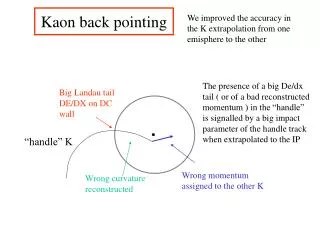
Pointing at Places in aGeospatial Theory Richard Waldinger and Peter Jarvis Artificial Intelligence Center SRI International Jennifer Dungan Ecosystem Science and Technology Branch NASA Ames Research Center Workshop on the Analysis of Geographic References May 31 2003 NAACL-HLT 2003 Edmonton, Alberta
Claim: Georeferencing can be studied in a logical geospatial theory.Claim: Georeferencing scheme can be tested by employing it in an application.
Geo-Logica: Answering Natural-Language Queries • Sample queries • Show Edmonton, Alberta, Canada. • Display a NIMA map for the countries that border Turkey and that border Iraq. • Show a place 100 miles north of a lake in Israel. • Show a petrified forest in Zimbabwe that is north of the capital of Botswana and within 200 miles of Arcturus, Zimbabwe.
The Structure of Geo-Logica Query translated to logical conjecture by Gemini. Conjecture proved by SNARK in the context of geospatial theory. SNARK can combine information from ADL Gazetteer, Semantic Web, and other sources. Answer as text, map, or visualization.
Nested Place Names • Canada is • feature(country, canada, earth) • (abbreviated as canada). • Alberta is • feature(province, alberta, canada) • Edmonton is • feature(city, edmonton, • feature(province, alberta, canada)) • General naming structure • feature(<type>, <name>, <region>)
Query into Logical Conjecture • Show a petrified forest in a country that borders South Africa? petrified-forest(?z) & in(?z, ?x) & country(?x) & border-relation(?y) & source(?y, ?x) & goal(?y, south-africa) & show(?u) & patient(?u, ?z) Answer: ?u • Gemini (Dowding et al.)
The Geospatial Theory • Facts of life represented by axioms: if is(feature(?type1, ?name1, ?region1)) then in(feature(?type1, ?name1, ?region1), ?region1) Hence, Alberta, Canada is in Canada.
Deductive Reasoning • Proves the conjecture follows from the axioms of the geospatial theory. • Extracts answer to query from proof. • Consults external sources during proof search. • Employs special procedures for spatial and temporal reasoning. • SNARK (Stickel)
Consulting External Source • Query: place-to-lat-long(?name, petrified-forest, zimbabwe, country, -15.22, -22.93, 33.65, 25.11 ?lat, ?long) • Response place-to-lat-long(makuku, petrified-forest, zimbabwe, country, -15.22, -22.93, 33.65, 25.11, -15.65, 29.95) • Found name and location of a Zimbabwe petrified forest within bounding box. • Alexandria Digital Library Gazetteer
Place Visualization • TerraVision satellite image • NIMA maps • GMT maps
Naming Problems Faced • Alternative Names • Kabul versus Kabol. • Prague versus Praha. • Bangkok versus Krung Thep. • Subregions • Kansas City, KS versus Kansas City, MO. • Rio de Janeiro, Peru.
Other Aspects of Geo-Logica • Information extraction as a source. • Time and dates. • Information-seeking dialogue. • Explanation generation. • Intelligence applications.