Download
1 / 21
210 likes | 475 Vues
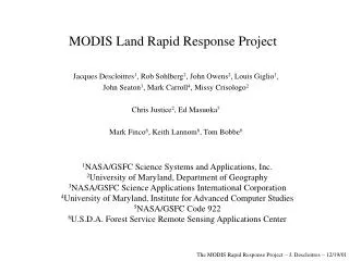
The MODIS Rapid Response Project. Jacques Descloitres 1 , Rob Sohlberg 2 , John Owens 2 , Louis Giglio 1 , Chris Justice 2 , Mark Carroll 4 , John Seaton 3 , Missy Crisologo 2 Mark Finco 5 , Keith Lannom 5 , Tom Bobbe 5. 1 NASA/GSFC Science Systems and Applications, Inc.

E N D
The MODIS Rapid Response Project Jacques Descloitres1, Rob Sohlberg2, John Owens2, Louis Giglio1, Chris Justice2, Mark Carroll4, John Seaton3, Missy Crisologo2 Mark Finco5, Keith Lannom5, Tom Bobbe5 1NASA/GSFC Science Systems and Applications, Inc. 2University of Maryland, Department of Geography 3NASA/GSFC Science Applications International Corporation 4University of Maryland, Institute for Advanced Computer Studies 5USDA Forest Service Remote Sensing Applications Center Support from Ed Masuoka (NASA/GSFC Terrestrial Information Systems Branch), Tim Gubbels (NASA-HQ Natural Hazards applications program), and Vince Salomonson (NASA/GSFC MODIS Team Leader) The MODIS Rapid Response Project – J. Descloitres – 07/24/02
Background • The complexity of the ECS production and distribution system does not always permit rapid access to MODIS data – System contingencies may significantly delay data availability • The most optimistic data turnaround is acceptable for some but not all applications: Level-1B data not available earlier than 24-48hrs, Level-2 available a few days later, Level-3 composite products 8/16 days later • Rapid data access is most critical at least in two areas: active fire detection and PR imagery • Manual workarounds have been developed in 2000 to provide rapid PR imagery to the Earth Observatory in response to specific events • Expedited active fire information derived from MODIS was handcrafted and provided to the Forest Service to document fires in Montana/Idaho during summer 2000 The MODIS Rapid Response Project – J. Descloitres – 07/24/02
Approach • To develop a rapid and flexible processing and distribution user-driven system as an alternative to the ECS system • To provide enhanced PRand outreach for some of the unique capabilities of MODIS • To generate value-added science-quality products to augment the MODIS standard products – Initial emphasis on combined Active Fire Detection / Corrected Reflectance product • To reuse existing software, hardware and expertise (e.g., ESIP-funded MODIS 250m Production System, MODIS Land Global Browse Processing System) • Develop applications partnerships with other agencies (e.g., USDA Forest Service) The MODIS Rapid Response Project – J. Descloitres – 07/24/02
System Characteristics • MODIS Level-0 data from NOAA’sNRT System (using existing “bent pipe” feed mechanism used to generate weather products) • L0 data processed with IMAPP software (DAAC processing code modified for Direct Broadcast applications) • Geolocation derived from spacecraft attitude and ephemeris data – No definitive attitude • No real-time ancillary data necessary • Processing system fully automated – No operator • Corrected reflectance and active fire locations produced within 2-5hrsof data acquisition and automatically sent to Rapid Response distribution site and to partners The MODIS Rapid Response Project – J. Descloitres – 07/24/02
Terra Aqua USDA Forest Service Remote Sensing Application Center Direct Broadcast Receiving Station EDOS NOAA University of Maryland Geography Dept Rapid Response System NASA/GSFC GES DAAC NASA/GSFC L1B Data MODIS Rapid Response Project: Design December 2001 T+30min Cumulative Fire Maps http://www.fs.fed.us/eng/rsac Backup Feed L1B Data Updated twice daily Active Fire Locations Burn Severity Maps Handcrafted Imagery T+5hrs Active Fire Locations Selected Imagery Active Fire Locations GOFC Fire Partners MODIS L0 Data T+2-5hrs T+5hrs Active Fire and Corrected Reflectance http://rapidfire.sci.gsfc.nasa.gov Web Fire Maps and Fire Feature Server http://rapidresponse.umd.edu MODIS home page http://modis.gsfc.nasa.gov NASA Earth Observatory http://earthobservatory.nasa.gov The MODIS Rapid Response Project – J. Descloitres – 07/24/02
Distribution Approach • RGB imagery with Active Fire overlay is archived and distributed to the public by the Rapid Response System at NASA/GSFC • Near-real-time imagery: http://rapidfire.sci.gsfc.nasa.gov/production/ (full production) • Selected handcrafted imagery: http://rapidfire.sci.gsfc.nasa.gov/gallery/ • On-line archive – No ordering interface • Straightforward “point-and-click” web interface • Application-specific products distributed by partners (e.g., web fire maps by University of Maryland, cumulative fire maps by Forest Service) • Privileged relationship developed with selected science image publishers to increase product visibility: Earth Observatory, Visible Earth, MODIS home page, Science Visualization Studio The MODIS Rapid Response Project – J. Descloitres – 07/24/02
Example of Active Fire / Corrected Reflectance ProductStar fire in California (08/29/01) The MODIS Rapid Response Project – J. Descloitres – 07/24/02
Example of Active Fire / Corrected Reflectance ProductRodeo fire in Arizona (06/19/02) The MODIS Rapid Response Project – J. Descloitres – 07/24/02
Example of Active Fire / Corrected Reflectance ProductSiberia (05/22/01) The MODIS Rapid Response Project – J. Descloitres – 07/24/02
Example of 250m Corrected Reflectance ProductHurricane Erin (09/11/01) The MODIS Rapid Response Project – J. Descloitres – 07/24/02
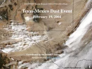
Example of Corrected Reflectance ProductDust Storm in Western Africa (05/08/01) The MODIS Rapid Response Project – J. Descloitres – 07/24/02
Example of 250m Corrected Reflectance ProductBrazil/Bolivia (08/02/01) The MODIS Rapid Response Project – J. Descloitres – 07/24/02
Example of 250m Vegetation IndexRondonia, Brazil (08/02/01) The MODIS Rapid Response Project – J. Descloitres – 07/24/02
MODIS Rapid Response Products used by Fire Managers • MODIS provides a new synoptic view at high resolution and gives the “big picture” to planners for resource allocation • Remote sensing avoids limitations of airborne platforms (heavy smoke, limited flight resources, limited geographic coverage) • Helps focus reconnaissance resources and prepare rehabilitation work on the ground USFS Remote Sensing Applications Center (Salt Lake City, Utah): Provider of geospatial and remote sensing support to USFS and related agencies National Interagency Fire Center (Boise, Idaho): National coordination center for all federal and state wildfire resources USFS Fire Science Lab, Rocky Mountain Research Station (Missoula, Montana): Smoke forecasting and fire behavior research Burned Area Emergency Rehabilitation Teams: Federal inter-agency program to mitigate impacts on water quality and ecology The MODIS Rapid Response Project – J. Descloitres – 07/24/02
The MODIS Rapid Response Project – J. Descloitres – 07/24/02
Blue Complex Fire16 August 2001 Oregon California Nevada Active Fire in REDPreviously Burned in YELLOW The MODIS Rapid Response Project – J. Descloitres – 07/24/02
MODIS Rapid Response Systemand Direct Broadcast Applications • Science products developed to support both DAAC Level-1 data and Direct Broadcast Level-1 data • Rapid Response processing progressively transitioned to Direct Broadcast • First field implementation prototyped in December 2001 with USDA Forest Service • Standard Rapid Response products generated within minutes of acquisition • Code sharing approach: ongoing effort to make Rapid Response processing available to Direct Broadcast users through Direct Readout Lab at NASA/GSFC • Active fire detection code distributed in April 2002 The MODIS Rapid Response Project – J. Descloitres – 07/24/02
Recent Progress • Implemented new band combinations to enhance snow/ice, floods, burn scars • Substantial improvement of input feed from NOAA NRT System since June 2002 (less than 1% data loss) • Implemented version 4 of active fire detection algorithm • Implemented a Rapid Response Vegetation Index product • Developed new partnership with USDA Foreign Agricultural Service (crop monitoring, food security applications) • Corrected Reflectance and Vegetation Index products available to Direct Broadcast users in July 2002 • Clustered production system (multi-processor, multi-machine) • Started transition to NOAA – Waiting for support • Streamlined image generation process – Increased feed to Earth Observatory (new Natural Hazard section), MODIS home page, Visible Earth, PAO • Increased PR: 1100+ images sent to Visible Earth database • Growing popularity: 5675 different visitors and 75000 images downloaded from Rapid Response site in June 2002 • Aqua: first light images processed in Rapid Response System – Still some geolocation issues to solve The MODIS Rapid Response Project – J. Descloitres – 07/24/02
Aqua First LightNorthern Australia (06/25/02) The MODIS Rapid Response Project – J. Descloitres – 07/24/02
Aqua First LightShark Bay, Australia (06/25/02) The MODIS Rapid Response Project – J. Descloitres – 07/24/02
For more information http://rapidfire.sci.gsfc.nasa.gov http://rapidresponse.umd.edu The MODIS Rapid Response Project – J. Descloitres – 07/24/02