Automated Geoprocessing Application Evaluation & Presentation
This project involves evaluating and presenting an automated geoprocessing application using Python script tools. The write-up includes a detailed synopsis, extended abstract, pseudocode, acknowledgements, and keywords. The presentation part requires explaining the project and showcasing a prerecorded demo. For the live demo, all necessary files are submitted for running the code, default values in GUI are set, and portability is checked. Lastly, a thumbnail image is created for the project gallery.

Automated Geoprocessing Application Evaluation & Presentation
E N D
Presentation Transcript
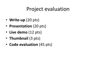
Project evaluation • Write-up (20 pts) • Presentation (20 pts) • Live demo (12 pts) • Thumbnail (3 pts) • Code evaluation (45 pts)
Write-up (20 pts) • Title • Synopsis --<=4 sentences • Extended abstract: (<=300 words) • Pseudocode • Acknowledgements • Keywords
Presentation (20 pts) • Two parts: • Explain the project (<=5 minutes) • Description of the problem (screen recording with voiceover for distance ed). • Include a checklist of the required and advanced functionality (met or not met). • Prerecorded demo (<=5 minutes) • Demonstration of running the code. • Both distance and traditional students prerecord a video. Jing recommended for free video screen capture
Live demo (12 pts) • Submit all files needed to run code – maps, scripts, toolboxes, data, so forth • Set default values in GUI • Check for portability
Thumbnail (3 pts) • image for the project gallery. • This should be a small JPEG, GIF, or PNG image file, 62 pixels wide and <=62 pixels tall. Select an image that represents the topic of your project. See project gallery for examples. The latest version of Windows Programs > Accessories > Paint allows you to resize images. • Name it userid.*
Code evaluation (45 pts = 20+20+5) • Required components (20 pts): • Python geoprocessing. • Python batch processing. • Use Python script tools and script tool properties to generate an appropriate interface. • Provide a toolbar button to launch the script tool. • Inform the user of progress, using progressor and messages. • Automatically display geoprocessing output in the map. (If the output is better viewed outside of ArcMap, you must still display it automatically. But also show messages so that the user knows how to find and display the visual output in a more appropriate viewer.) • Programming style (20 pts): • use of variables; minimal hard-coding • use of data structures such as lists/dictionaries to streamline code (instead of long if/elif/elif/elif... blocks.) • lightly commented but also self-documenting (easy to guess what's happening) • use of procedures/modules to organize/streamline code so that related blocks of code are grouped and reusability is facilitated when possible. • avoid use of 'magic numbers' -- hard-coded numbers unique values with unexplained meaning and/or multiple occurrence which could (preferably) be replaced with meaningfully named variables • catch exceptions, as appropriate • lines of code <=80 chars. Achieve this by using variables to hold long string arguments and using line continuation symbols as needed. • Instructor feedback implemented. • Level of difficulty (5 pts)