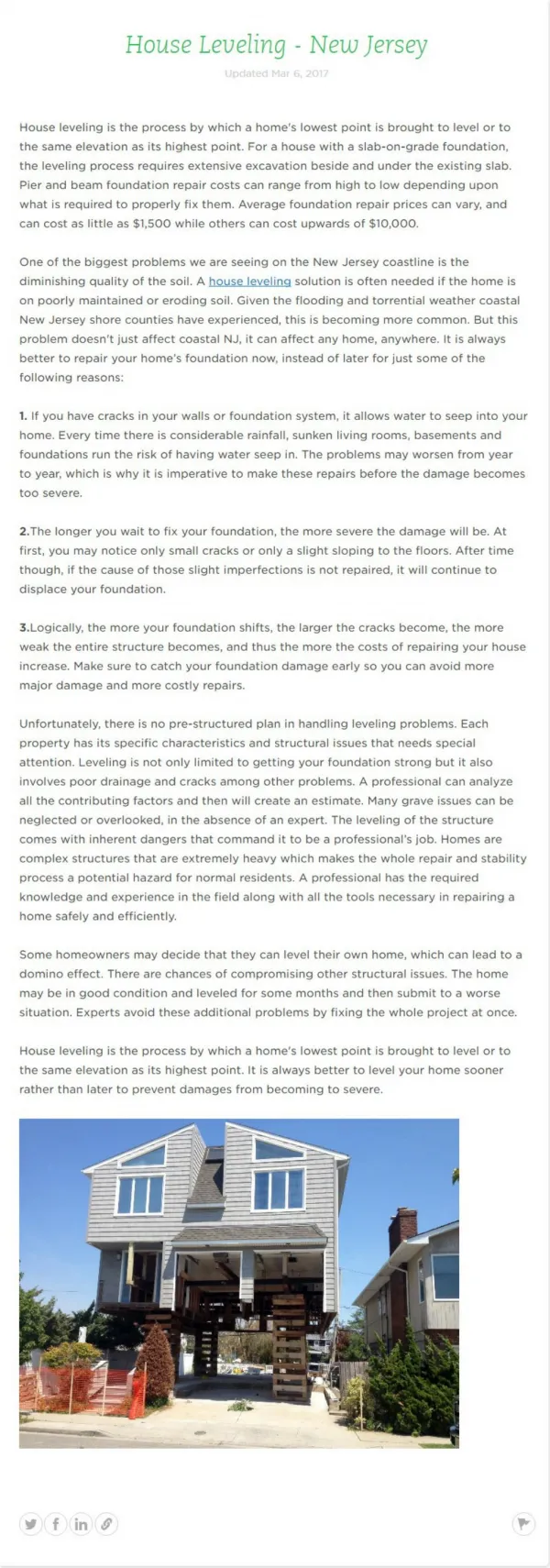
Download
1 / 34

E N D
What is “Leveling” • Levelling is the process by which differences in height between two or more points can be determined. Its purpose may be to provide heights or contours on a plan, to provide data for road cross-sections or volumes of earthworks, or to provide a level or inclined surface in the setting out of construction works
Mean Sea Level(MSL) • Mean sea level (MSL) is the average (mean) height of the sea between High and Low tides
1-Barometric leveling :There is an inverse relationship between height and air pressure value . In Barometric leveling determined the differences in elevation between points surveying by value of the measured air pressure at the point
Water Level • Transparent flexible tube of about 14 m long. • The tube is filled with water so that the water level is about 1 m high in each of the tube ends. It is essential that no air bubbles be trapped in the tube. Air bubbles can be removed by tapping the tube with the finger. • Wherever the two staffs are set, the free water surfaces in the tube ends have the same level
1-Leveling Equipment • One of the most common operations in Ag and Construction surveying. • Used to determine differences in land elevation in reference to a level plane. • The most basic tool used for leveling is known simply as a level or tripod level.
Principles of Operation • Imagine a carpenters level fitted with a support tripod and a set of sights. If leveled the line of sight will be a level line. • Every point across the line is at the same elevation. • Can be used as a reference line to determine the difference in elevation of points on the ground.
Types of Levels • Instruments are identified by the primary use for which they are intended. • Dumpy level • Transit • Contractor’s level • Farm level • Automatic level
Types of Levels • Dumpy Level • Rigidly constructed • The tube, supports, and horizontal bar are all made in one casting. • 4 Leveling screws are used to level the instrument to the horizontal plane. • Generally used for: • Profiles • Differential Surveys • Drainage & Irrigation • Building Layout
Types of Levels • Transit • Constructed to move sideways and in a vertical plane. • Otherwise like a dumpy level • Used for: • Roads • Buildings • Vertical Planes
Types of Levels • Contractor’s Level • The site tube is set inside a turret. • Used for: • Building Layout • Foundations • Elevations
Types of Levels • Farm Level • Lightweight, dependable, and inexpensive. • Used for: • Contour mapping • Irrigation • Elevation • Grades • Terracing
Types of Levels • Automatic Level • Once leveled it will maintain its level automatically. • Allows for: • Quick set-ups • Error minimization • Very accurate • Very expensive • Used when very rapid and accurate measurements are needed.
Parts of the Level • Telescope Tube • Sighting device • Precision optics to enlarge • Eye Piece • Used to adjust the focus of the crosshairs • Crosshairs • Used to align or center the line of site with a perpendicular object. • Objective Focus • Used to focus the objective lens, to focus on the view • Objective • A compound lens that forms an image of the object being sighted. • Sunshade • Located on the objective used to reduce glare. • Level Tube • Used to indicate levelness or the line of sight • Leveling Screws • Supports for adjusting the level tube. • Plumb Bob Attachment • Located on bottom of instrument • Serves as center point of the instrument.
Proper Care of Levels • Always transport instrument in its carrying case when moving locations. • Place all lens caps and tripod caps in instrument box to prevent loss. • Never force or over tighten leveling screws. • Protect lenses from direct sun.
2-Tripod • Loosen tripod leg friction screws before setting up or moving tripod. • Carry instrument when attached to the tripod under arm with instrument forward. Never over the shoulder. • Use lens tissue to clean lenses. 1- from wood
Leveling Staffs The staff is simply a large ruler, available in lengths of 3, 4 or 5 metres and usually made of aluminium with telescopic sections
Reading the E Staff • Color Alternates every metre • Each graduation is 100mm • Each “E” is 50mm • Metre height & 1/10m is located in lower 50mm • Each Part of the E is 10mm • Millimeters are interpolated • Staff is read to the millimeter
Reading an “E-face” staff 0.339 0.33 0.3
Reading Staffs • It is important to hold staff plumb • Use slow rocking technique • Use vertical line in level to keep plumb
Removing Staff Reading Errors Step 2 Staff Slowly Tilted away from Instrument. When Vertical lowest reading will be reading recorded Step 1 Staff Slowly Leant Towards Instrument Step 3 Staff Slowly Tilted away from instrument. Once past vertical readings will increase Important Note – The person using the instrument keeps the staff vertical by use of the Vertical line in the instrument.
Stadia Reduction • The middle line is the line of Collimation • The Short lines are called stadia lines • Usually Stadia multiplier is 100
Stadia Reduction • Upper stadia = 3.040 • Lower stadia = 2.946 • Stadia difference = 0.094 • Distance to staff = 0.094 x 100 = 9.4 metres
Stadia Reduction • Method used for Measuring Distance • Not Very Accurate (1mmVrt=100Hz) • Not to be used to setting out • Used with Horizontal Circle to make contour drawings