Google Earth
Google Earth. Jill Antonsen and Kerri Hilbelink. Where are we?. Download. Video Earth. Just Getting started.


Google Earth
E N D
Presentation Transcript
Google Earth Jill Antonsen and Kerri Hilbelink
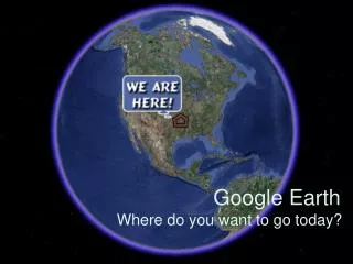
Where are we? Download
Just Getting started • View an image of your school, home, or any place on Earth - Click Fly To. Enter the location in the input box and click the Search button. In the search results (Places panel), double click the location. Google Earth flies you to this location. Search button • Go on a tour of the world - In the Places panel, check the Sightseeing folder and click the Play Tourbutton: • Get driving directions from one place to another and fly (follow) the route - See Getting DirectionsandTouring the Route. • View other cool locations and features created by other Google Earth users - In the Layers panel, check Community Showcase under Google Earth Community. Interesting placemarks and other features appear in the 3D viewer. Double click these points of interest to view and explore. • View 3D terrain of a place - This is more fun with hilly or mountainous terrain, such as the Grand Canyon. Go to a location (see number 1). When the view shows the location, use the zoom slider to tilt the terrain. • View 3D buildings - This works best in a big city, such as San Francisco or New York. Travel to a city (see number 1). In the Layers panel, select 3D Buildings. Watch the buildings appear.
Getting Started Cont. • View Sky - Teaching your students about the solar system? Use Sky to assist you. When you're viewing Earth, you can switch to Sky at any time. Just click View > Switch to Sky or click . In Sky, the Earth is hidden and the 3D viewer presents a view of the sky. • Sky is much like a interactive planetarium on your computer. You can see brilliant, detailed imagery of celestial objects millions of light years away. For example, the Crab Nebula appears here in the 3D viewer. You can also view stars, constellations, galaxies, planets and the Earth's moon. View Volcanoes and Earthquake faults - Whether your class is studing the world's volcanoes or earthquakes, you can see them by turning on these layers in Google Earth. To see volcanoes, in the Layers panel, select Volcanoes under Gallery. To view earthquake faults, in the Layers panel, selectPlaces of Interest, Geographic Features, and then Eathquakes. • View Historical Maps - Google Earth includes an amazing collection of historical maps from the David Rumsey Collection. To view these incredible maps, in the Layers panel, select Rumsey Historical MapsunderGallery. • View Weather Information - Google Earth contains an entire layer of up-to-date weather information. You can view the current weather conditions for your school's neighborhood. To view weather activity, go to a location (for example, enter your school's address). In the Layers panel, select Weather. You can see the clouds, radar, conditions and forecasts, and additional weather information.
Live Video • Go into Google Earth and actually see what is happening while you are viewing it.
Create Narrated Tours • Narrated Tour Tutorial
Google and Education • Google Earth puts the world’s geographic information at the student’s fingertips. • Teachers are able to use geography in a new way to teach literature, history, math environmental science, and so much more. • The Educators Community within Google gives tips and tricks to use this resource as a teaching tool through lesson plans of all grade levels and subjects.
Social Studies • You can make placemarks • You can click on any place and it will give you background information from past history. • Making Tours and Animations • Drawing lines and paths • Drawing polygons on the map
Science • Google Earth contains many layers: • Weather • Investigate clouds and thunderstorms • Zoom in on any location and find local forecast • Animal Behavior & Habitats • Find interesting facts on any animal you click on and their habitat • You can also track past movements
Science cont. • Ocean: • Teach Marine Life with Cousteau Ocean World • Provides information about different marine life and their natural environment • Ocean Protection and Climate Change • You can be almost up to the minute ocean observations, monitor ocean surface temperature, and look at dead zones in ocean. • Space • Lunar Field trip-Identify key elements of what human life on the Moon would be like • Rockets • Lunar Sports-effects of gravity
Mathematics • Concept lessons will use Google Earth to present math topics, such as rates or scientific notation in unique ways. • Measurement lessons will make extensive use of the ruler tool in Google Earth to accomplish problem solving activities. • Exploratory lessons will follow non-traditional math topics such as fractals, topology, or modern geometry. • Math Lessons
English/Language Arts • Google Lit Trips • Allows you to follow characters in Literature with downloadable files that are marked out on Google Earth. There are pop-up windows are various markers which contain relating media and other resources about that portion of the story. • Used for elementary to high school