Download
1 / 30
300 likes | 520 Vues
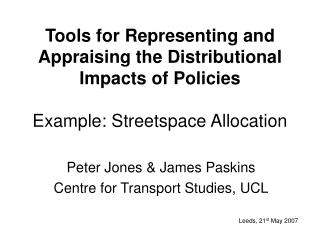
Tools for Representing and Appraising the Distributional Impacts of Policies Example: Streetspace Allocation. Peter Jones & James Paskins Centre for Transport Studies, UCL. Leeds, 21 st May 2007. Current Situation.

E N D
Tools for Representing and Appraising the Distributional Impacts of PoliciesExample: Streetspace Allocation Peter Jones & James Paskins Centre for Transport Studies, UCL Leeds, 21st May 2007
Current Situation • Authorities encouraged to measure distributional impacts of strategies and schemes – but little guidance • Main advice relates to taking into account effects of income differences (e.g. equivalence scales, distributional weights) • Recent legislation in UK to ensure no discrimination, in terms of disability, age, ethnicity, gender – strengthens case for examining distributional impacts
Distributional Dimensions • WHO: Social group distribution (‘vertical equity’): • Directly affected (e.g. children) • Indirectly affected (e.g. parents) • WHERE: Spatial distribution (‘horizontal equity’): • Design area • Wider impact area • WHEN: Temporal distribution: • Time period • Generational/cohort differences
Requirements of Tools • Aid identification of relevant social groups, plus spatial and temporal impact areas • Identify relevant categories and measures of impacts • Provide basis for assessing gainers and losers, and severity/significance of change • Consider possibility of integration into current appraisal methodologies
Types of Tool Development • Congestion charging: Bristol, Edinburgh (PROGRESS), WebTag guidance • Accessibility Planning: Barnsley Dearne, South Yorkshire • Streetspace reallocation: Bloxwich, West Midlands
Streetspace Reallocation • Increasing emphasis on redesigning high streets: • Encourage more sustainable modes • Regenerate high streets & increase liveability • Given space/capacity limitations, more for one group often means less for others • Need a method of assessing design needs and gainers/losers under different options
Place status (A, B, C, D and E) City District Neighbour hood National Local Link status (I, II, III, IV and V) National I-A I-B I-C I-D I-E City II-A II-B II-C II-D II-E Arterial streets District Non-arterial streets III-A III-B III-C III-D III-E Neighbour hood IV-A IV-B IV-C IV-D IV-E Local V-A V-B V-C V-D V-E Link/Place classification matrix Source: ‘Link and Place - A Guide to Street Planning and Design’ Determine Street Type
Street type … I - E … III - B … V - E User group Retail ü ü Pedestrians ü ü Pedestrians who have mob ility difficulties ü Those using the street to socialise/relax ü ü Cyclists ü Bus users visiting the street ü ü Those travelling to other destinations ü ü Car users (non - disabled) visiting the street t ü ü Disabled car users visiting the street … Select Street User Groups/Activities
Blocks – Colour and Size • Use colour to denote different types of space usage • Some based on current street colour categories; e.g. blue = disabled parking (blue badge) • Size represents to scale space required to accommodate feature
Appraisal Spreadsheet • Compares the impacts of various street designs on different user groups • Inputs include desired and actual levels of provision for each street element • Output is a comparison of the impacts for the various user groups • Following example replaces 6 parking bays with a bus stop
User Impact Matrix • Matrix indicates relevance of different street features to different user groups • Impacts are only positive (1) or negative (-1); the matrix does not include any weighting
The screenshot shows the spreadsheet being used to show the impacts of replacing 6 parking spaces with a bus stop Provision and Impacts Proposed plan elements are entered here Current plan elements are entered here
Provision and Impacts The impact matrix is used to calculate the impacts from the current provision and for the proposed plan
Spreadsheet Output • Comparison shows there will be a positive impact for bus users and negative impacts for car users (including disabled car users) • BUT this comparison did not take account of: • the relative importance of the user groups or • the ideal or maximum numbers of elements
Adding User Group Weights • The weightings in the matrix could be altered (e.g.) to favour plan options that: • Prioritise bus users • Prioritise disabled car users • Discourage car use by other groups
Bus user weighting Car user weighting Disabled user weighting Revised Impact Matrix • The weightings are then fed into the impact matrix……….
Street Element Weighting • There may be an upper limit, or ideal number of a particular element • The spreadsheet currently allows a maximum provision point to be set; after this point, increasing provision does not increase the benefit for any group • It is possible to include other relationships, for instance diminishing returns
Setting a Cut-Off Point • In this example, the maximum number of parking spaces has been set at 6 Adding extra spaces does not increase the benefit
Spreadsheet with Weightings • The revised impact matrix now includes the following: A. User Group Priorities: • Priority for bus users • Priority for disabled drivers • De-prioritising car users • Cut-off point for parking spaces: • After 6 have been provided there is no benefit from additional provision
The Effect of Weighting • Unweighted matrix • Weighted matrix:
Conclusions • Spreadsheet currently under development, as an aid to option appraisal/selection – and to more targeted option generation • Encourages more explicit treatment of objectives, priorities and needs • More work required on inputs • BUT, as yet, does not take into account location of design elements along a street
Shops 4 Bus Stop P Value of Relative Location?
Contact Details • james@transport.ucl.ac.uk • peter.jones@ucl.ac.uk