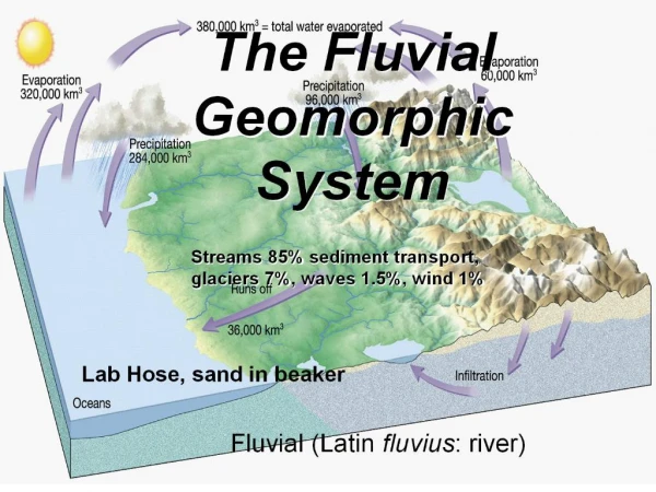
The Fluvial Processes
The Fluvial Processes. Chapter 16. Streams and Stream Systems. Two types of running water Overland flow -- Movement of surface water Stream flow – channeled movement of water along a valley bottom Two topographic elements for stream systems

The Fluvial Processes
E N D
Presentation Transcript
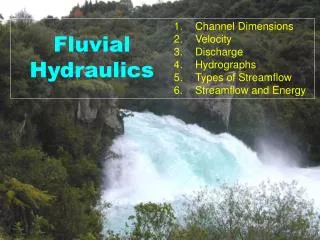
The Fluvial Processes Chapter 16
Streams and Stream Systems Two types of running water Overland flow -- Movement of surface water Stream flow– channeled movement of water along a valley bottom Two topographic elements for stream systems Valley -- that portion of the terrain in which a drainage system is clearly established. Interfluve – the higher land above the valley sides that separates adjacent valleys.
Drainage Basins Watersheds – an area that contributes overland flow and groundwater to a stream. Consists of a stream’s valley bottom, valley sides, and those portions of the surrounding interfluves that drain toward the valley Terminates at the drainage divide, the line of separation between runoff that descends in the direction of the drainage basin in question and the runoff that goes toward an adjacent basin
Stream Orders A systematic relationship of how smaller streams merge into larger streams as the water moves down the drainage basin. First-order stream- smallest unit in the system, one without tributaries Second-order stream- when two first order streams merge into a larger stream Third-order stream – the confluence of two second-order streams The joining of a lower-order stream with a higher-order stream does not increase the order below the junction. Only the conjunction of two of the same order streams increases the order of the new stream
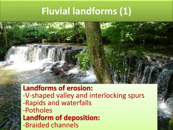
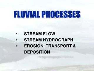
Fluvial Erosion and Deposition Erosion by Overland Flow Begins when rain starts to fall Without vegetation or some other protective covering the collisions with the ground is strong enough to blast fine soil particles upward and outward shifting them a few millimeters downhill by the “splash erosion” In the first few minutes much of the rain infiltrates the soil and the “runoff” starts. If a heavy rain continues and the land is sloping the water moves down slope as overflow
Fluvial Erosion and Deposition Sheet erosion– as water flows across the surface as a thin sheet, transporting material already loosened by splash erosion Rills– tiny channels of overland flow as it moves down slope and its volume increases and turbulence causing “rill erosion” Gullies and gully erosion – as rills grow in size forming gullies which cause gully erosion
Erosion is accomplished in part by the direct hydraulic power of the moving water. Erosive capability is enhanced by the abrasive tools a stream picks up and carries along with it. Some chemical weathering processes called “corrosion” help to erode Erosive effectiveness of stream flow varies enormously, depending on the speed and turbulence of the flow on one hand and the resistance of the bedrock on the other hand Erosion by Stream Flow
Any water moving down slope, whether moving as overland flow or as stream flow, can transport rock material Stream load – the mass of material that reaches the stream bottom plus the stream-eroded debris. Stream load can contain: Dissolved load -- some minerals, mostly salts dissolved in the water and carried in solution Suspended load– fine particles of clay and silt carried suspended in the water without ever touching the streambed. Bedload – sand, gravel, and larger rock fragments found on the bottom of the stream. Small particles bouncing along are called saltation. Coarser pieces move by traction. Transportation
Transportation Debris -- transported some distance, dropped, and then picked up later and carried farther Competence-- a measure of the particle size a stream can transport, expressed by the largest particles that can be moved. Capacity – a measure of the amount of solid material a stream has the potential to transport, normally expressed as the volume of material passing a given point in the stream channel during a given time interval.
Deposition Whatever is picked up must eventually be set down, which means that erosion is inevitably followed by deposition. Alluvium – general term for stream-deposited debris, characterized by a sorting of particles on the basis of size.
Role of Floods Perennial streams – permanent streams, carry water all year round Ephemeral streams – streams that carry water during the wet season or during or immediately after rains Intermittent streams – flow for only part of the year. Ephemeral and intermittent are applied to both of these kinds of water flow
Channel Flow – confined to channels (different from overland flow) Three-dimensional nature with considerable complexity Movement in the channel, unsystematic and irregular Principal cause of flow irregularity is retarding effect of friction along the bottom and sides of the channel. Turbulence- general downstream movement interrupted by irregularities in the direction and speed of the water. Caused partly by friction, partly by internal shearing stresses between currents with the flow, and partly by surface irregularities in the channel. Effect of turbulence is varied because it is selective process. Stream Channels
Stream Channel Patterns • Stream channel patterns are generally grouped into four categories • Straight channels– short and uncommon, usually indicative of strong control by the underlying geologic structure. • Sinuous channels– more common, found in almost every type of topographic setting • Meandering channels– extraordinarily intricate pattern of smooth curves in which the stream follow a serpentine course, the land is usually flat • Braided Streams–a multiplicity of inter-woven and interconnected channels separated by low bars or islands of sand, gravel, and other loose debris
Structural Relations • Relationship of stream to the geologic-topographic structure. • Types of Streams • Consequent stream- develops on newly uplifted land • Subsequent stream - streams that develop along zones of structural weakness – tend a right angles • Antecedent stream - a drainage system that is interrupted by an uplift of land that is so slow the stream is able to maintain its previously established course • Superimposed stream – originally established on a higher sequence of land that has been entirely or largely eroded away-so original drainage pattern becomes incised into the underlying sequenced rocks
Stream Drainage Patterns • Response to underlying structure • Dendritic pattern – most common – tree like • Trellis pattern – response to underlying structures consisting of alternating bands of tilted hard and soft strata with long parallel streams linked by short right angle segments • Radial Pattern – streams descend from some sort of concentric uplift- such as an isolated volcano • Centripetal Pattern – opposite of a radial pattern usually associated with streams converging in a basin • Annular Pattern – develops either on a dome or in a basin where dissection has exposed alternating concentric bands of titled hard & soft rock
Dendritic pattern Trellis pattern Radial or Centripetal pattern Angular pattern
Shaping and Reshaping of Valleys • Valley Deeping – Stream expends most energy in down cutting • Base level – the lowest level or limit a stream will down cut a valley- the imaginary surface extending underneath the continents from sea level at the coast • Graded Stream – a stream which the gradient just allows the stream to transport its load
Valley Deepening • Knickpoint Migration • Knickpoint- waterfalls & rapids found in valleys • Knickpoint migration • Knickpoint formed where a stream flows over a resistant layer of rock • The water flows undercuts the lip • Causes the knickpoint to collapses • Position of the knickpoint has migrated upstream
Valley Widening • Takes place with combined action of weathering, mass wasting, and overland flow • Lateral erosion –as stream flows from side to side
Valley Lengthening • Valley Lengthening happens in two different ways • Headward Erosion and Delta formation • Headward Erosion – overland flow from the interfluve drops abruptly over this slope break where the water tends to undercuts the rim of the perimeter, weakening it and often causing it to collapse. This causes a decrease in the interfluve and an increase in the valley area • Stream Capture – when a portion of a stream basin is diverted by headward erosion into another basin • Elbow of Capture- the abrupt bend in the stream channel where the capture took place • Delta Formation- a valley that is lengthened seaward by deposition
1 2 3 4
Deposition in Valleys • Alluvium is collected in the bottom of the valley • This alluvium is call aggradation
Floodplains • A low lying, nearly flat alluvial valley floor that is periodically inundated with flood waters. Often formed where a meandering stream flows across a wide nearly level valley floor • Landforms • Floodplain – entire floor of the flatland that floods • Bluffs – outer limit of lateral erosion and undercutting where the flat terrain abruptly changes to a line • Cutoff meander – a loop is short-circuited as a stream cuts a new channel across its neck and starts meandering again – leaving the old meander loop • Oxbow lake – the old meander loop • Oxbow swamp – the oxbow lake as it fills with vegetation • Meander scars – as vegetation grows over the cutoff meanders and oxbow lakes leaving only scars
Modifying Rivers for Flood Control • Use of Dams, artificial levees, and overflow floodways. • Flood control on the Mississippi and its delta a good example • The delta of the Mississippi is a “Birds-foot delta”
Stream Rejuvenation • Where a stream has large flood plains, it is mature when there has been • Tectonic uplift • River begins to down cut the original floodplain • After lift- river again widens out a floodplain • Leaving remnants of the original valley floor as “Stream Terraces” • Entrenched Meanders – topographic features are formed when an area containing a meandering stream is uplifted and the steam incises downward • Canyonlands a good example
Theories of Landform Development • Davis Geomorphic Cycle – developed in the early 1900’s • Cycle of Erosion • Youth- streams become established and a drainage pattern begins to take place • Maturity – the main stream approach equilibrium condition having worn away falls and rapids developing smooth profiles • Old age – over long periods- erosion reduces the entire landscape to near base level – sloping land dominated by extensive flood plains • Rejuvenation – uplift happens during any cycle starting the whole process again • Penck’s theory of Crustal change and slope development • Theorized parallel retreat instead of slope reduction. • Equilibrium Theory – accepted over the last 4 decades • Erosion reduces relief about as fast as uplift rises the land- elevations of the mountains remains essentially constant overtime