Download
1 / 25
260 likes | 451 Vues
Explore the dynamic processes of rivers in the fluvial geomorphic system, including erosion, sediment transport, and deposition. From bedrock channels and waterfalls to drainage divides and distributaries, learn about the factors affecting stream behavior. Discover the impact of water volume, gradient, velocity, and channel size on river landscapes. Uncover the role of rainfall intensity, soil texture, and vegetation cover in infiltration and groundwater flow. Understand how streams shape their surroundings through erosion, sediment transport, and deposition, influencing landforms like alluvial channels, gullies, and deltas. Dive into the mechanisms of erosion, including abrasion and plucking, and how waterfalls evolve over time. Gain insights into sediment transport processes, from dissolved to bedload, and the concept of stream competence. Witness the transformative power of floods and how they impact sediment deposition and river profiles, shaping the landscape over time. Discover the intricate balance between potential and kinetic energy in rivers and the role of base level in controlling stream behavior.

E N D
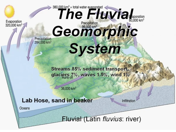
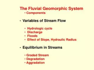
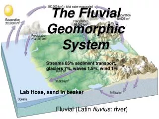
The Fluvial Geomorphic System Streams 85% sediment transport, glaciers 7%, waves 1.5%, wind 1% Lab Hose, sand in beaker Fluvial (Latin fluvius: river)
Conversion Potential energy (elevation) to Kinetic Energy(motion). Most energy lost to friction, but 2-4% of total potential energy converted to work of erosion and transportation Drainage Divide Tributaries • Gradient decreases downstream • Factors that increase downstream: • Velocity • Discharge • Channel size Distributaries And Delta Trunk Stream
Infiltration • Infiltration is controlled by • Intensity and duration of rainfall • Prior wetted condition of the soil • Soil texture • Slope of the land • Nature of the vegetative cover http://plantandsoil.unl.edu/croptechnology2005/soil_sci
Stream water feeds • Infiltration (rain and snowmelt soak into soil) • water moving in pore spaces • Throughflow water moving through voids in soil • In cracks, burrows, root casts, etc. • Runoff • Sheetflow = overland flow • thin slow surface layer • transitions into rill erosion Sheetflow
Rill Erosion, Gully formation Rill: a trickle of water, a very small stream Gully: a small watercourse with steep sides, usually cut into soil Source:Ramesh Venkatakrishnan Gully. Larger channels, they persist, grow headward and widen. Rill Erosion. Individual Channels do not persist
Discharge • The amount of water passing through a channel cross-section in unit time • Q = v * A where v is theaverage flow velocity [meters / second] through a cross section A [meters2] Thus Q has units meters3/second
Photo by Natalie Romanoff Used with Permission Bedrock Channels Cut down by: • Solution Weathering - Limestone • Plucking (= quarrying) esp. jointed rocks • Fast moving water gets in cracks and pushes blocks free. Cycles of wetting and drying, or freezing and thawing, loosen blocks • Abrasion • the impact of rolling and bouncing detritus. Notice I skipped page 200 lower right beginning "Soil Erosion" and resumed page 203 right "Bedrock Channels"
Waterfalls • p 205 right "In stratified rocks of contrasting lithology … each resistant layer forms a waterfall in a bedrock channel, usually with a plunge pool" that scours the underlying beds. • p206 left (paraphrased for clarity) As the waterfalls migrate headward, if the resistant layer dips headward, waterfalls will [become smaller]; if layers dip seaward, the waterfall may grow in height.
Local change in base level affects river profiles: nickpoints Resistant layer dips headward
Alluvial Channels • Channels usually lined with alluvium • Removed and carried further downstream during flood • Re-deposited during wane
Width, Depth, Current Velocity and Longitudinal Profile "As mean discharge of a river increases downstream, channel width, channel depth, and mean current velocity all increase." p 207 r para 1 Drainage Divide Tributaries • Gradient decreases downstream • Factors that increase downstream: • Velocity • Discharge • Channel size Water flows with less friction in larger channels maintains velocity with less slope p209 l Distributaries And Delta Trunk Stream
Ultimate Base Level Control • At sea level, no further conversion of potential energy to stream work is possible. • Sea level lowered at least 100 m during peaks of glaciation. Headwaters were higher, stream water had more potential energy, faster streams cut deep canyons • All rivers now enter the sea via estuaries (drowned lower valleys) or deltas (sediment filling lower valleys).
Overbank deposition during flooding Flood over banks into wider area, lower velocity, sand drops.(Muddy water over floodplain)
We can recognize past floods Floods change the local conditions 6_6 Fine-grained sediment on floodplain Older sediment 1 Pre-flood Bounders on bottom, sands and muds suspended Flood water Erosion of uppermost fine-grained sediment 2 Flood stage Flood: One source of Graded Bedding Fining-upward flood deposit Bedding plane is an erosional surface 3 Post-flood skip 211r, 212, 213
Important definitions Load, Competence • Streams transport sediment • Transported material is called load • Types of load • Dissolved load – ions in solution from weathering • Suspended load – fine particles* • Bed load Moves during high velocity events Sandy Portion – Saltation (bouncing) Cobbles – Traction (rolling) • Competence – Largest particles it can move Proportional to velocity squared KE = 1/2 mV2 *Our Buckingham Pi studies of grain in fluid
Deposition of sediment by a stream • Caused by a decrease in velocity • Competence is reduced • Sediment begins to drop out http://www.geo.cornell.edu/geology/classes/Geo101/graphics/AKbraid_stream.gif
Similitude Page 215 • For model studies that teach us about the real world, Similitude (similarity) is needed • Dimensionless numbers such as the Reynolds Number Re = rvR/m must be the same in model and real world • R is the channel cross sectional area divided by the length of the wetted perimeter skip 216, 217, 281 left
Dimensionless Numbers for Streams • Froude Number Fr = v type of turbulence (gd)1/2 • Tranquil, or supercritical flow. Latter standing wave, resistance to flow • Supercritical mostly in narrow bedrock channels in flood • Reynolds Number Re = rvR/m laminar or turbulent • Drag Coefficient CD = Fgrain suspension rV2D2 These are related to competence and erosion
Capacity • Maximum mass of sediment a stream can transport. • Measured by amount of suspended load. skip 219 220 left
Channel Shape, Habit, Solid Load • Q determines cross-sectional channel shape and • HABIT (shape from space) measured using thalweg • Straight: Suspended load channels (<3% bedload) • Meandering: single sinuous channel, carries mostly suspended load, with point bars, loops • Braided: bedload > 11% total, high channel width to depth, mid-channel bars Background: Figure 10-15 from text, p.221, after Schumm, 1981 Braided Stream
Erosion and deposition along a meandering stream Meanders get more extreme with time. Note the THALWEG (blue arrows)
Channel moves in direction of cutbank Pointbar advances as crossbed drapes Meandering Stream Oxbow Floodplain http://hays.outcrop.org/gallery/rivers/arid_meander?full=1
Reminder: Point Bar Sequence Fines of Floodplain Crossbeds of Bar Gravel of bed Erosion
Braided Streams • Braided: high total load; bedload > 11% total, high channel width to depth; mid-channel bars Braided Stream
Graded Streams • Grade: natural tendency toward self regulation • Changing conditions cause adjustment • Sudden extra sediment narrows channel: so faster flow and much more erosion during flood, so blockage removed and previous channel shape reestablished. Demo: narrow channel of lab hose http://www.tweed.nsw.gov.au/Education/rm_4_bankerosion.htm