Trade Winds in Equatorial Pacific
330 likes | 631 Vues
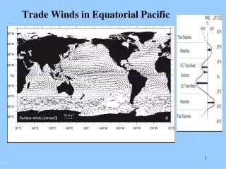
Trade Winds in Equatorial Pacific. ITCZ Location. ITCZ. July. ITCZ. January. Equatorial Divergence vs Subtropical Convergence. upwelling. downwelling. Trade Winds Cause Variations in Sea Surface Height. ITCZ. ITCZ. SSH. ITCZ. TradeWind Speed.

Trade Winds in Equatorial Pacific
E N D
Presentation Transcript
ITCZ Location ITCZ July ITCZ January
Equatorial Divergence vs Subtropical Convergence upwelling downwelling
Trade Winds Cause Variations in Sea Surface Height ITCZ ITCZ SSH
ITCZ TradeWind Speed Meridional Trends in Trade Wind Strength, Sea Surface Height, and Currents in the Equatorial Pacific I------Conv------IDivIConI-Div-I---Conv---I Surface Current Direction westward eastward SSH (cm) HPG Depth (m)
Zonal (east-west) trend in Sea Surface Height Zonal (E-W) Trend in Sea Surface Height Wind Stress SSH Temperature (+ = depth of EUC)
Velocity Cross Sections Equatorial Undercurrent EUC Velocity (m/s) Temperature (ºC) A A 6
Temp Cross Sections in the Equatorial Pacific Salinity Oxygen Phosphate Zonal Vel.
Effect of El Nino on Anchovy Catch El Ninos in red
Array of Buoys Monitored by NOAA for Wind Speed, SST, Salinity, Current Velocities The best instrumented region of the world’s ocean
Weakening of Trade Winds during El Nino Normal El Nino
Atmospheric Circulation and Precipitation Changes during El Nino Normal El Nino
SST and Chlorophyll during El Nino El Nino Normal 9
Animation of SST Anomalies during El Nino of 1997 • http://www.cdc.noaa.gov/map/clim/sst_olr/old_sst/sst_9798_anim.shtml
History of Southern Oscillation Index(and correlation with El Nino events) ENSO Index
Change in Zonal Atmospheric Circulation in Equatorial Pacific
El Nino Effects on US Temperatures (Winter) Warmer in northern midwest and cooler in south
El Nino Effects on US Precipitation (Winter) Wetter in southeast US
Currently El Nino Conditions (Nov 2009) SST anomaly is currently 1-4ºC warmer than normal (avg.= 1.5ºC).