quaternary scour hollows
280 likes | 1.19k Vues
Outline. Glaciations of the UK:- - The Devensian GlaciationAssociated features:- - Erosional features - Fluvio-glacial features - Depositional features - Periglacial featuresPingos - Description - Definition - Formation (open

quaternary scour hollows
E N D
Presentation Transcript
1. Quaternary Scour Hollows Origins, characteristics and locations in relation to the uk, with specific reference to Central London
2. Outline Glaciations of the UK:-
- The Devensian Glaciation
Associated features:-
- Erosional features
- Fluvio-glacial features
- Depositional features
- Periglacial features
Pingos
- Description
- Definition
- Formation (open & closed system)
Scour Hollows:- - Characteristics
- formation
Associated hazards
Case study:-
- Central London
Summary
References
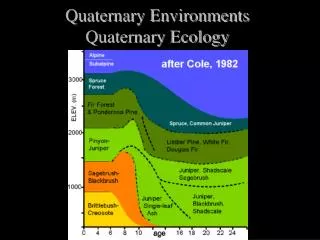
3. Glaciations of the UK Three major glaciations have taken place in the UK:- Anglian (ended 425,000 years B.P) Wolstonian (ended 135,000 Years B.P) Devensian (ended 10,000 years B.P)
The greatest of these being the Anglian, which is believed to have extended as far south as Suffolk, N. London and Oxford.
The Wolstonian glaciation has been shown to have the 2nd greatest southerly extent reaching parts of Anglia and Oxfordshire, but no further
The Devensian shows the least southerly extent of the 3 glaciations and has been shown to cut diagonally across the UK (see next slide!)
5. Devensian Glaciation The glaciation lasted approximately between 70,000 B.P and 10,000 B.P. The ice flowed out from a dome, centred over Sweden and Finland, with the ice around 2km thick at deepest point! Smaller glaciations seen over the Alps and Pyrenees, due to the increase in altitude and decrease in temperature. Southern and some central parts of England were effected by periglacial conditions.
6. Erosional Glacial Features: Ar�tes
Cirques
Corries
Fjords
Glacial troughs
Glacial lakes
Grooves
Horns
Polished rock surfaces
Rouche moutonnees
Scouring
Striae
U-shaped valleys
Valley steps
7. Fluvio-glacial Features: Erosional Features:
Bowls
Channels
Meltwater channels
Potholes Depositional Features:
Meltwater deposits
Ice-contact sediments
Kettle holes
Kames
Eskers
Kame terraces
Outwash fans
Deltas
Varve clays
Shorelines
8. Glacial Depositional Features: Drumlins
Erratics
Hummocky moraines
Landforms
Streamlined
Non-streamlined
Terminal or end-moraines, lateral moraines
Till
Lodgement till
Ablation till
Meltout till
9. Periglacial Features: Aeolian deposits
Anomalies beneath river terraces
Frost Creep
Frost stirring & sorting
Frost cracking
Glacial overflow & marginal channels
Glacio-eustatic / isostatic effects
-Buried valleys
-Sub seal level caves
-Reactivation of coastal landslides
-Leaching of former marine sediments
-Intra plate faulting & earthquakes
Ice dammed lake deposits
Thermokarst
Periglacial landslides & rockfalls
Periglacial solifluction
-Granular materials
-Clayey materials
Pingos
-Open system
-Closed system
Superficial valley disturbances
Weathering
-Physical
-Chemical
12. �Definition taken from �The New Oxford Dictionary of English��
��A perennial conical or dome-shaped mound (often with a crater on top) found in regions with thin or discontinuous permafrost and consisting of a layer of soil over a large core of ice, the width being much greater than the height; also, a round depression or rampart in temperate regions thought to be the remains of such a mound formed when the climate was colder�.
"Pingo" is an Eskimo word for "isolated hill".
Pingos: Definitions
21. The above diagram shows the London area with the various locations of the scour hollows
Taken from Quarterly journal of Engineering Geology: Vol 12, No.1,1979,pg 12
22. Case study: Central London The top of these features often have sharply descending cliff like walls, up to 12.2m in height
Maximum depth hollows reach is proved to be 33m below ground level
Hollows range in size across shortest axis from 92m to 475m wide!
The above dimensions mean that the hollows can contain several hundred m3 of material and cover large areas of land
23. Case Study: Central London Scour hollows show gradational transition from drift to Tertiary strata across the lower parts of the walls
Typically the hollows are infilled with drift, clays, sands and gravels, with some fluvial sediments seen
Majority of material originates from the London Clays, with reworked sediment from the Woolwich and Reading beds also being seen
24. Case Study: Central London Relationships to drainage:-
Zeuner (1959) believed the hollows were located near the mouths of the tributaries to the Thames due to a fluvial origin
Fairly precise coincidence is seen with the pingos found at The Fleet Valley, Lea and Ty-Bourne junctions, with the Thames
The hollows seen from Battersea to Vauxhall also seem to coincide with the junction of three stream/river channels
25. Case Study: Central London Relationships to drainage:-
These correlations would seem to suggest that these hollows had a fluvial origin and were created by old river channels
However, the fact that these features occur at stream junction/tributaries may be a coincidence as it is not unusual for open-system pingos to occupy such positions (see photo overleaf)
27. Case Study: Central London Relationships to drainage:-
It is believed that the hollows in the London area have suffered modification due to fluvial scour, but it is not considered that this mechanism accounts for the hollows origin
It is thought that the collapsed pingo mounds would have been eroded away by rivers, allowing fluvial scour to occur at the roots
This process streamlined the upper parts of the pingo and allowed replacement of the original infill by fluvial sediments
28. Case Study: Central London Summary:-
Deposition occurred in a period of interstadial and interglacial warming
The hollows were formed first during the Devensian glaciation, with fluvial scouring occurring when large tracts of ice and snow melted during the interstadial/ interglaciation
The hollows are infilled with drift, clay, sand and gravel, with much of the material being reworked sediments of the surrounding strata
30. Scour Hollows: Hazards The hydrological properties and porosity of the infill is often completely different from that of the surrounding strata
The presence of these sands and gravels pose a major flood hazard if a hollow is cut into when tunnelling through the London Clay
If these hollows are not picked up during the site investigation this may add considerably to the cost of civil engineering
31. References: �Late Quaternary scour-hollows and related features in central London� The Quarterly Journal of Engineering Geology, Volume 12, Number 1, 1979, pages 9-29,
F.G.BERRY
�Permafrost features as evidence of climatic change*1", Earth-Science Reviews, Volume 15, Issue 4, April 1980, Pages 327-402 A. L.WASHBURN
�Geomorphology and hydro geological significance of the Holocene pingos in the Karup Valley area, Traill Island, northern east Greenland� Journal of Quaternary Science. Volume 11, Issue 3, Date: May/June 1996, Pages: 249-262
PETER WORSLEY, STEPHEN D. GURNEY
�The development of periglacial geomorphology: 1- up to 1965� Permafrost and Periglacial Processes
Volume 14, Issue 1, Date: January/March 2003, Pages: 29-60
HUGH FRENCH
�A preliminary report on the Stanton Harcourt Channel Deposits (Oxfordshire, England): geological context, vertebrate remains and Palaeolithic stone artefacts� Journal of Quaternary Science, Volume 11, Issue 5, Date: September/October 1996, Pages: 397-415
CHRISTINE M. BUCKINGHAM, DEREK A. ROE, KATHARINE SCOTT
32. References: �Permafrost on the Tibet Plateau, China,� Quaternary Science Reviews, Volume 14, Issue 3, 1995, Pages 255-274 Baolai Wang and Hugh M. French
�Some mechanical aspects of pingo growth and failure, western Arctic coast, Canada� Mackay, J R Can J Earth Sci V24, N6, June 1987, P1108�1119, International Journal of Rock Mechanics and Mining Science & Geomechanics Abstracts, Volume 25, Issue 2, April 1988, Page 55
�Some mechanical aspects of pingo growth and failure, western Arctic coast, Canada� Mackay, J R Can J Earth Sci V24, N6, June 1987, P1108�1119, International Journal of Rock Mechanics and Mining Science & Geomechanics Abstracts, Volume 25, Issue 1, February 1988, Page A3
�On the origin of pingos �� A comment�, Journal of Hydrology, Volume 30, Issue 3, July 1976, Pages 295-298 J. Ross Mackay�
�Ice-shaped ring-forms in Western Canada: their airphoto expressions and manifold polygenetic origins�, Quaternary International, Volumes 68-71, June 2000, Pages 187-198 J. D. Mollard�
�Possible late Quaternary pingo remnants in Central London� Nature, 1980. Vol. 284. Pages 253-255
Hutchinson.J,N