Download
1 / 25
250 likes | 497 Vues
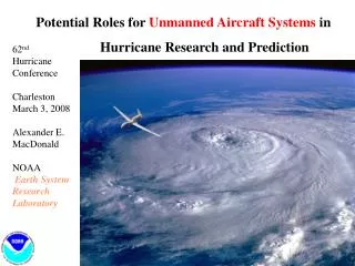
Potential Roles for Unmanned Aircraft Systems in Hurricane Research and Prediction. 62 nd Hurricane Conference Charleston March 3, 2008 Alexander E. MacDonald NOAA Earth System Research Laboratory. Two Keys to Hurricane Intensity:.

E N D
Potential Roles for Unmanned Aircraft Systems in Hurricane Research and Prediction 62nd Hurricane Conference Charleston March 3, 2008 Alexander E. MacDonald NOAA Earth System Research Laboratory
Two Keys to Hurricane Intensity: • Numerical model with resolution high enough to resolve the eyewall ( 1 km) • Ability to continuously, quantitativly monitor the storm intensity - 1 to 3 hour temporal resolution - Continuously for the 3 day period before landfall.
There are a great variety of UAS. Altair Predator B Global Hawk Aerosonde Global Observer Zephyr AEM in situ
NOAA UAS Program Funded! • Program will apply to all NOAA missions • This presentation: Tropical Storms • Program Manager: Marty Ralph • Budget: $ 3.3 M in 2008, $ 6.3 M in 2009
Examples of Hurricane Missions for UAS: • Global Hawk to loiter above the hurricane. • Aerosonde into the hurricane at low levels. • Zephyr over hurricanes for days at a time.
NOAA is working with NASA with the goal of using the Global Hawk as a platform for hurricane recon. • Global Hawk could loiter above hurricanes for extended periods, and: • Dropsondes • Radar sampling • Scatterometry • Radiometry
NOAA Demonstration of the Global Hawk High-Altitude Long-Endurance (HALE) UAS NASA Global Hawk UAS Dryden Flight Research Ctr.
Global Hawk UAS Two Global Hawk UASs have been acquired by NASA Dryden Flight Research Center, CA, and will be used, in part, for earth science research and application studies • Fully autonomous • Communication: UHF Line of Sight, INMARSAT Beyond Line of Sight • 25600 GTOW, 9100lb Empty Wgt, 14500 Max Fuel • Wingspan 116 ft • 210 - 335 KTAS • 1500 - 2000 lb Payload • Performance: Alt 65,000 ft, Range 11,000 nm, Endurance 31 hrs Bay A G H D E F Bay J Bay B I Bay C
Examples of Hurricane Missions for UAS: • Global Hawk to loiter above the hurricane. • Aerosonde into the hurricane at low levels. • Zephyr over hurricanes for days at a time.
NOAA/NASA Noel Aerosonde UAS mission Aerosonde was launched from NASA’s Wallops Flight Facility at 14:08 EST on Friday November 2, 2007. Mission endurance was 17 hours 27 minutes and resulted in 7.5 hours of data collection in the core of the hurricane at altitudes less than 100m.
Take-off from Wallops Flight Facility (KWAL) 1600 UTC Nominal altitude for the Aerosonde prior to entering the storm’s core circulation was between 300-600m. Near the center, UAS altitude was ~150m. Aerosonde P-3 (3500 m) “Eye” loitering with vertical soundings (90-1500 m) KMCF Rendezvous with P-3 at storm center 0525 UTC
Examples of Hurricane Missions for UAS: • Global Hawk to loiter above the hurricane. • Aerosonde into the hurricane at low levels. • Zephyr over hurricanes for days at a time.
ZEPHYR - Long Duration (Many days) UAS • Built by QinetiQ Corporation (UK) • Problem: Payload only 4 kg !!!!!!!
Zephyr HALE UAS • Long endurance from solar-electric power • Weeks/months flight endurance • Operating altitude 50,000 - 65,000ft • No environmental impact • Drop micro-sondes into hurricanes or monitor oceanic weather events for long periods • Satcom capable – commercial Iridium • Low cost platform for payloads, plus: • No regular maintenance • No operating base needed • Launch and recover from ship’s deck • Fewer personnel required • No fuel distribution network needed • Zephyr flies for longer for less money • ~$1m production platform cost
Ultra-light Dropsonde * ESRL/GSD issued RFP for dropsonde in 2006 * Spec: Closest to 20 gram sonde wins * Winner: Applied Research Associates
Dropsonde Mechanical Design • Populated housing with attached streamer • 38.3 grams • Foam housing • 3.5 inch diameter • 2.3 grams • Air pathways for sensors
Dropsonde Electronics • Packaging – Open cell foam w/ streamer • Microprocessor – NXP LPC2138 • Transmitter – TI CC1100, 300MHz – 1GHz • Pressure – Intersema MS5534B • Humidity – Sensiron SHT75 • Temperature – Platinum RTD • GPS – Ublox LEA-5S • Power – ER14250, Li 1/2AA 3.6VDC
Production System Concepts • Streamer-based dropsonde dispenser
Zephyr – in-situ measurement using drop-sondes Lightweight drop-sondes dispensed into developing weather event or storm at intervals to measure PTU and wind speed