Topographic Data Interpolation for Elevation Points at Sample Site Coordinates
This data set includes topographic data points at multiple elevations for a sample site located at 39.36.52.47N, 104.47.05.57W. The dataset offers various interpolation methods, including 4-point and 12-point weighted interpolations, to provide accurate elevation data. Both 30-second and 3-second resolution data are available, along with 30-meter resolution data points. Graphic and digital profile representations are included for in-depth analysis. Explore the elevation data points at this sample site.

Topographic Data Interpolation for Elevation Points at Sample Site Coordinates
E N D
Presentation Transcript
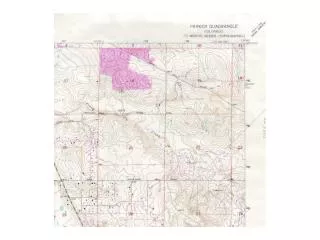
Sample Site 39 36 52.47N 104 47 05.57W 5755ft MSL
Sample Site 39 36 52.47N 104 47 05.57W 5755ft MSL 30-Sec Data (5787ft)
Sample Site 39 36 52.47N 104 47 05.57W 5755ft MSL 30-Sec Data (5787ft) 3-Sec Data (5741ft)
Sample Site 39 36 52.47N 104 47 05.57W 5755ft MSL 30-Sec Data (5787ft) 3-Sec Data (5741ft) 30-meter Data (5753ft)
Sample Path 30-Sec Data 3-Sec Data 30-meter Data