GIS Tutorials for Watershed Management
GIS Tutorials for Watershed Management. Andrea Bolks , Jared O’Brien, Adam Thada Indiana Watershed Leadership Academy May 2013. Goal.

GIS Tutorials for Watershed Management
E N D
Presentation Transcript
GIS Tutorials for Watershed Management Andrea Bolks, Jared O’Brien, Adam Thada Indiana Watershed Leadership Academy May 2013
Goal • Create a watershed management-oriented tutorials to show spatial data. Programs include ArcGIS Desktop, ArcGIS Explorer , ArcGIS Online and Data 2 Maps and are focused for those with average computer competency. • Create a product that can be built upon in the future by others in the IWLA
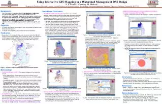
Guides • ArcGIS Explorer Guide1: Site Locations Map • ArcGIS Online Guide1: Site Locations Map • ArcGIS Online Guide 2: Watershed Boundary Map • ArcGIS Guide: Adding x,y Locations • Data2Maps (D2M) Large Sample Size Guide
Why ArcGIS Explorer Desktop? • http://www.esri.com/software/arcgis/explorer • Why? • Free! • Compatible with numerous basemaps and layers already available • Customizable – use your own data • Map production • Spatial analysis • Can handle large datasets
Download and Open ArcGIS Explorer • 2. Add Sampling Locations Options: • Adding a shapefile of your sampling locations (a shapefile that was already created in a GIS program such as ArcMap) • B) Adding sites with a text file of x,y locations (that can be created using excel or another spreadsheet tool) • C) Drawing point “notes” in Explorer
5. Create a Map Image World Physical basemap Bing Maps Aerial basemap World Streets basemap
WhyData2Maps? • https://wiki.epa.gov/watershed2/index.php/Data2Maps • Why? • Free! • Customizable – use your own data • Spatial Sampling data Analysis • Geared toward storm water analysis
Why ArcGIS Online? • http://www.arcgis.com/about/features.html • Why? • Free! • Compatible with numerous basemaps and layers already available • Customizable – use your own data • Map production • Share Online maps
Download and Open ArcGISExplorer. Open map. • 2. Add Watershed Boundaries • A) adding a shapefile • B) query a map service, such as National Watershed Boundary Dataset (WBD) • or…
C) Draw approximate boundary with “note” tool • 3. Changing the Symbology
4. Bookmarking a view • 6. Save map • 7. Create map image or share map online • 8. Access your map through your acount • 5. Changing the Basemap
Tutorials available at: • http://bit.ly/IWLA-Tutorials