Download
1 / 17
170 likes | 407 Vues
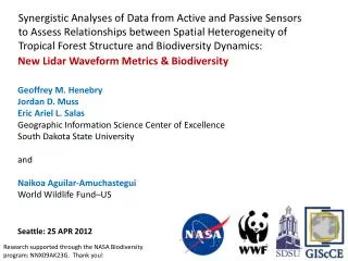
Synergistic Analyses of Data from Active and Passive Sensors to Assess Relationships between Spatial Heterogeneity of Tropical Forest Structure and Biodiversity Dynamics. Jordan Muss 1 , Naikoa Aguilar-Amuchastegui 2 , Geoffrey Henebry 1

E N D
Synergistic Analyses of Data from Active and Passive Sensors to Assess Relationships between Spatial Heterogeneity of Tropical Forest Structure and Biodiversity Dynamics Jordan Muss1, Naikoa Aguilar-Amuchastegui2, Geoffrey Henebry1 1South Dakota State University & 2World Wildlife Fund, US
Biodiversity conservation through the sustainable management of tropical forests: • Forest structural heterogeneity as a potential indicator of sustainable forest management • Relationships between forest management & biodiversity indicators • Forest structural heterogeneity linked to habitat availability: • birds (e.g.Barbaroet al. 2006; Goetz et al. 2007; Clawgeset al. 2008) • mammals (e.g. Carey & Wilson 2001) • beetles (e.g. Aguilar-Amuchastegui & Henebry 2006, 2007; Barbaroet al. 2006)
Study Area 9forested sites 3 natural reference 1 natural & intact 2 natural but fragmented 6managed units 5 primary 1 old secondary
Why do we need more lidar metrics? Quantiles Fixed-width Slicing • Gaussian Deconvolution
Alternative Approach • Shape-based metrics • Centroid (Cx, Cy) • Balance point of waveform • Relates to canopy height • Radius of Gyration (RG) • root mean square distance between the centroid and waveform edge • Relates to 3D structure of canopy Muss et al. (2012) Geoscience & Remote Sensing Letters
Recursive slicing • Bounds detection using C and normalized RG • Measuring wave complexity using RG
Automated Bounds Detection • Multi-pass rule-based recursive slicing: • Slice waveform • Find & remove slices with symmetry around Cslice: • N(Rgup) ~ N(RGdown) • Repeat until: • N(Rgup) ≠ N(RGdown) • Or the slices are too small to process
Orange = Pasture • Green = Forest • Circle = Flat site • Triangle = Sloped site
Slicing Using the Radius of Gyration • Multi-pass recursive slicing: • Minimize RG differences between slices • Slice wave at height where minimum difference occurs • Repeat for upper &lower portions until wave can’t be sliced any further
Summary: • Shape-based metrics can be used to process lidar waveforms & identify waveform complexity • Differences in waveform complexity appear to be related to forest management practices Future Directions: • Lacunarity analysis of UAVSAR data for sites • Incorporate scale of fluctuation from passive optical data • Incorporate biodiversity data with spatial patterns of lidar metrics & spectral indices
“A solution looking for a problem.” Thanks to: Adriana Tovar, Prof. Manuel Spinola, Eric Salas, DebolinSinha Lidar data were provided by the Laser Vegetation and Ice Sensor (LVIS) team in the Laser Remote Sensing Branch at NASA Goddard Space Flight Center with support from the University of Maryland, College Park. Funding Source: NASA Biodiversity program