CONCENTRIC ZONE MODEL
Universidad Simón Bolívar Subject: Inglés para Arquitectura y Urbanismo II Teacher: Olga Lista Section: 2. CONCENTRIC ZONE MODEL. Members: Gabriela Di Pasquale Andrea Mendez. TOPICS. Introduction ……………………………………………………......................... 3

CONCENTRIC ZONE MODEL
E N D
Presentation Transcript
Universidad Simón Bolívar Subject: Inglés para Arquitectura y Urbanismo II Teacher: Olga Lista Section: 2 CONCENTRIC ZONE MODEL Members: Gabriela Di Pasquale Andrea Mendez
TOPICS Introduction ……………………………………………………......................... 3 The Model ………………………………………………………………………………. 4 Zones ………………………………………………………………………………………. 5 Study of Concentric zone model ………………………………………………. 7 Problems………………………………………………………………………………….. 8 Conclusion……………………………………………………………………………….. 9
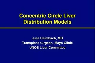
CONCENTRIC ZONE MODEL The Concentric ring model also known as the Burgess model is one of the earliest theoretical models to explain urban social structures. It was created by sociologist Ernest Burgess in 1925. Commuter zone Residential zone Working class zone Zone of transition Factory zone CBD
THE MODEL Based on human ecology theories done by Burgess and applied on Chicago, it was the first to give the explanation of distribution of social groups within urban areas. This concentric ring model depicts urban land use in concentric rings: the Central Business District (or CBD) was in the middle of the model, and the city expanded in rings with different land uses. It is effectively an urban version of Von Thunen'sregional land use model developed a century earlier. It contrasts with Homer Hoyt's sector model and the multiple nuclei model.
ZONES The zones identified are: Zone I: Central Business District (CBD) where most of the tertiary employment is located and where the urban transport infrastructure is converging, making this zone the most accessible. Zone II: Immediately adjacent to the CBD a zone where many industrial activities locate to take advantage of nearby labor and markets. Further, most transport terminals, namely port sites and rail yards, are located adjacent to the central area.
ZONES Zone III: This zone is gradually been reconverted to other uses by expanding manufacturing / industrial activities. It contains the poorest segment of the urban population, notably first generation immigrants living, in the lowest housing conditions. Zone IV: Residential zone dominated by the working class and those who were able to move away from the previous zone (often second generation immigrants). This zone has the advantage of being located near the major zones of employment (I and II) and thus represents a low cost location for the working class. Zone V: Represents higher quality housing linked with longer commuting costs. Zone VI: Mainly high class and expensive housing in a rural, suburbanized, setting. The commuting costs are the highest. Prior to mass diffusion of the automobile (1930s), most of these settlements were located next to rail stations.
ZONES Commuter zone Residential zone Working class zone Zone of transition Factory zone CBD
CONCENTRIC ZONE MODEL The most important feature of this model is the socio-economic relationship according to the distance from the central business district (CBD), this is the first circle and is located in the center of the model, depending on the size of this, change the size of rings around it and though these various, the order will always be the same. This model clearly shows the status of citizens of a region, because while they lived farther from downtown, major state owned and if they were closer, were considered low class or poor. The Burgess's work was based on the bid rent curve that was based on what people would pay for the land, being obviously more expensive the areas that were outward. Another characteristic of this work is that the CBS expanded more every time, invading the surrounding areas, thus ensuring that the distance between this and the suburbs were more.
PROBLEMS • It describes the peculiar American geography, where the inner city is poor while suburbs are wealthy; the converse is the norm elsewhere. • It assumes an isotropic plain - an even, unchanging landscape • Physical features: land may restrict growth of certain sectors; some characteristic as hills and water may make some locations desirable for residential purposes • Commuter villages defy the theory, being in the commuter zone but located far from the city • Decentralization of shops, manufacturing industry, and entertainment • Urban regeneration and gentrification - more expensive property can be found in 'low class' housing areas • Many new housing estates were built on the edges of cities in Britain • It does not address local urban politics and forces of globalization • The model does not fit polycentric cities, for example Stoke-on-Trent
CONCLUSION The Burgess model remains useful as a concept explaining concentric urban development, as a way to introduce the complexity of urban land use and to explain urban growth in many American cities in the early-mid 20th century. However, nowadays this model isn’t one hundred percent correct, less for cities in Latin America in which are including the cities of our country Venezuela.