CBRE Earth Tour
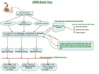
CBRE Earth Tour. User. Main form helps User select location type. Also Helps User Upload data from Excel file. Intersection. Address [Selected by Default]. Longitude & Latitude. Excel file on user’s local box. Uses file upload wizard with steps…. Select the filename.

CBRE Earth Tour
E N D
Presentation Transcript
CBRE Earth Tour User Main form helps User select location type Also Helps User Upload data from Excel file Intersection Address [Selected by Default] Longitude & Latitude Excel file on user’s local box Uses file upload wizard with steps… Select the filename. Write the sheet name. Verify columns. Loads Data Uses datagrid to enter Addresses or Intersections or Geocodes. click Edit to enter values and Save to finalize your values. Check locations Location entered is tested against Geocoder and closely related match is returned back. User can select its own location and update the main data grid Click on Open with Route Click on Driving Directions Click on Open with Icons Passes information to CBRE earth server Opens KML file with locations indicated by Route,icon shape and color. Opens a Web page with Map and Driving directions Opens KML file with locations indicated by only icon Shape and Color.