Download
1 / 16
160 likes | 328 Vues
FY09 GIMPAP Project Proposal Title Page Revised: October 31, 2008. Title : GOES Atmospheric Motion Vectors (AMV) Research Project Type : Product Improvement Status : Renewal Duration : 2 years Leads: Chris Velden – CIMSS (PI) Dave Stettner – CIMSS Howard Berger -- CIMSS

E N D
FY09 GIMPAP Project Proposal Title PageRevised: October 31, 2008 • Title: GOES Atmospheric Motion Vectors (AMV) Research • Project Type: Product Improvement • Status: Renewal • Duration: 2 years • Leads: • Chris Velden – CIMSS (PI) • Dave Stettner – CIMSS • Howard Berger -- CIMSS • Other Participants: • Jaime Daniels (ORA Collaborator) • Jim Jung (JCSDA Collaborator) • Kris Bedka – CIMSS • Iliana Genkova - CIMSS
2. Project Summary • Proposed Task 1: Continue the exploration of new and improved techniques for GOES AMV height assignments (largest source of vector RMSE). Two approaches: 1) Use the active measurements of cloud tops from Calipso to evaluate current GOES AMV height assignments. Write up preliminary findings. 2) Continue research on GOES AMV representation in terms of the *layer* being tracked. The goal is to move away from the traditional *level* height assignment. Preliminary results are quite encouraging to lower vector RMSE. This should benefit data assimilation. A manuscript is in preparation and will be completed/published during FY09. • Proposed Task 2: Continue the evaluation of improved “quality indicators” (QI) for GOES AMVs. Further testing of the “Expected Error” and “Correlated Error” QIs is necessary, but initial results show promise. Significance: 1) Potential to improve data assimilation, 2) Potential to replace cumbersome Auto Editor in the NESDIS operational AMV production algorithm. Write up initial findings.
3. Motivation/Justification • NOAA Mission Goals: • This product development primarily supports: Weather and Water • NOAA-wide Goals: • This product development primarily supports: Satellite Services • This research is being conducted to help mitigate the existing limitations of the GOES AMV product; directed at the two key areas of vector height assignment and quality confidence. The research strategies proposed are novel, and promise to improve on the product quality. • AMVs are a fundamental variable observable from GOES, and can have a high impact in NWP data assimilation and prognoses. The two key outstanding issues of vector height assignment and quality confidence are what we aim to address in this proposed research. • The proposed tasks build on a long and successful GIMPAP AMV research program at CIMSS. Both the national and international met communities have frequently cited the importance of GOES AMV products developed by CIMSS in collaboration with NESDIS/STAR under NOAA GIMPAP support. We use this as motivation to continue to search out ways to improve GOES AMV product development.
4. Methodology • We have collected large volumes of GOES AMV datasets extending over many months. The AMV datasets consist of vectors derived from GOES multispectral imagery. • We have collocated western hemisphere raobs. • Proposed Task 1)---Height Assignment. Matched AMV/raob comparisons have been compiled and statistically evaluated based on selected stratifications that address the *layer* vs. *level* height assignment issue. - Statistical analyses are performed to assess the AMV bias and RMSE characteristics in order to identify optimal AMV height assignments/representations (situational, by spectral band, etc). • Proposed Task 1)---Height Assignment. Calipso passes are collected/processed over GOES AMV coverage areas (can leverage other CIMSS grants with NASA and JCSDA for this purpose). - Collocated GOES AMVs, raobs and Calipso cloud height measurements are compared and evaluated. Height assignment biases are identified, and corrections evaluated. • Proposed Task 2)---Quality Confidence. The Expected Error (EE) results are being carefully compared to existing Auto Editor (AE) quality control output (Recursive Filter Flags) to assess if the EE can replace the cumbersome AE. - A thorough statistical analysis is being performed to reveal the performance metrics of each approach, and new concepts are being explored based on the findings in order to optimize the EE performance.
5. Expected Outcomes • In collaboration with STAR, a GOES PSDI is in place to facilitate transition of successful research results to the NESDIS operational AMV algorithms. • Documentation (User Guides and Journal articles) will be written describing/updating the results of the research (Proposed Tasks 1 and 2). • The ability to improve the GOES AMV product through the proposed research will be further investigated through data assimilation experiments (GIMPAP or JCSDA), and moved into operations if appropriate.
6. Progress in FY08 Milestones • Summary • Completed statistical assessment of proposed GOES AMV layer height assignment approach. Presented results at the International Winds Workshop (IWW) in April, 2008. Manuscript in preparation. • Nearing completion of initial exploration of GOES AMV height assignments against Calipso measurements. • Conducted an initial assessment of the Expected Error as a potential new GOES AMV quality indicator. Presented findings at the IWW. Promising results are being further explored.
6. Progress in FY08 Milestones Task: Examine GOES AMV height assignment via new “layer” approach Completed statistical assessment of proposed GOES AMV layer height assignment approach. Presented results at the International Winds Workshop (IWW) in April, 2008. Discussing possible model impact studies. Manuscript in preparation. 7
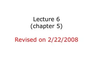
Results: GOES-12 (SGP) AMVs - Layer of Best Fit Imager VIS Imager SWIR • GOES-12 low-level AMVs (1000-600 hPa) best correlate to a 70-100 hPa tropospheric layer in depth • More difficult to evaluate low level vectors due to complex boundary layer and surface flows Imager Low-Level IR AMV-sonde VRMS at height assignment LEVEL Layer of Best Fit Depth=70 hPa Upper-level cloudy IR and WV AMVs (above 600 hPa) agree best with a shallower layer, ~30-50 hPa in depth - Layer of best fit improves agreement by 0.3 to 0.5 ms-1 Imager Clear-Sky WV Imager Cloudy WV Imager Upper-Level IR • Clear-sky WV AMVs best relate to a much deeper layer, 150-200 hPa in depth - Rao et al. (2002) show upper-level moisture content and/or gradients can modulate the layer of best fit depth for CSWV
6. Progress in FY08 Milestones Evaluate GOES AMV height assignments against Calipso measurements Completing an initial qualitative exploration of AMV height assignments against Calipso measurements. Starting quantitative evaluation (collocated Calipso, AMVs and raobs) Goal: to identify systematic bias or situational tendencies in the AMV heights using Calipso validation. Then reassign AMV heights to the Calipso altitudes and assess impact on AMV accuracy vs raobs. 9
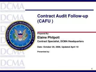
four 4km GOES pixels CALIPSO CLOUD TOP HEIGHT (CTH) TO GOES AMV HEIGHTS COLLOCATION APPROACH Part of a Calipso orbital path is shown in red - red and green are the subsequent 5 km pixel level CTH. FoEvery Calipso 5km pixel has Calipso Beginning (CB) pixel latitude and longitude, the Calipso Center (CC) pixel latitude and longitude, and the Calipso Ending (CE) pixel latitude and longitude. These latitude/longitude pixel locations will be used to co-locate the GOES/SEVIRI/ABI AMV locations. Two AMVs (one on the left and one on the right of the Calipso path) are shown as well with their corresponding target boxes. For the left AMV, the target box is gridded in order to illustrate how the 15x15 winds image pixels co-locate spatially with the Calipso pixels. The maximum allowed distance between an AMV target center and a CALIPSO orbit is approximately 30km. To compare the heights from winds and calipso there must be overlap, where overlap is defined to occur only when cloudy pixels are present. At most, 16 cloudy GOES pixels can overlap with the Calipso orbital path, and this will happen if Calipso’s orbital path is 45deg from an ideal North-South direction. An overlap of 16 pixels will only occur under total cloudy condition, or the occurrence of a cloud distribution along the target diagonal (magenta line). A minimum number of pixels should be required overlap to assure the comparisons will be physically meaningful. This minimum number will be determined empirically through testing.
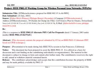
Windco AMV heights overlaying CALIPSO total attenuated backscatter at 532nm – Calipso CTH (the median value of all CALIPSO pixel heights falling within the AMV target) are shown with yellow circles and AMV heights –with red circles; AMV are extracted from 4 August 2006, 12 UTC
6. Progress in FY08 Milestones Evaluation of an improved GOES AMV quality indicator Conducted an initial assessment of the Expected Error as a potential new GOES AMV quality indicator. Finding: Using the EE alone, it is unlikely we can achieve the QC efficiency of the current auto-editor system without trimming vector quantities. New approach using combined QI and EE yields promising preliminary results, which are being further explored. 12
Impact of EE on GOES post- and Pre-RF AMV - RAOB: RMS Vector Difference RMS Vector Error (ms-1) Expected Error Maximum (ms-1)
7. FY09 Milestones • FY09 • Finish analyzing and documenting (including published journal paper) the results of the GOES AMV layer height assignment research, and assess for potential operational transition. Possible model impact studies. • Complete the assessment of the EE as a replacement for the existing Auto Editor as a quality control module for GOES AMV. • At the request of the CGMS and IWW, help coordinate (with EUMETSAT) an inter-comparison study of AMV processing methods between all global operational AMV providers (including NESDIS/GOES). Evaluate the strengths and weaknesses of all approaches and algorithms. Identify potential approaches/methods in use at other Centers that could improve GOES AMV processing/quality.
8. Funding Profile (K) Summary of leveraged funding NOAA-THORPEX grant provided some labor coverage for the initial work on AMV Expected Error exploration (this grant terminates in FY07). NASA-ASAP (Aviation product development) grant to CIMSS provided some labor coverage to the initial work on layer heights approach. This support is not expected in FY09 and beyond. NOAA NRC Fellowship provided some labor coverage to a researcher investigating the Calipso data approach (Fellowship has ended). Small JCSDA grant approved (FY08) to examine AMV assimilation optimization. In particular, the AMV height assignment issue. 15
9. FY09 Expected Purchase Items $80,000 FY09 Total Project Budget $80K Grant to CIMSS, March 2009 9 months Research Scientist support and overhead Computer charges Publication charges University overhead $0 Federal Travel $0 Federal Publication Charges 16