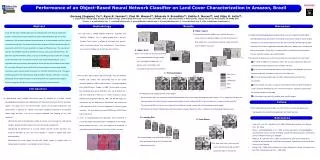
Performance of Object-Based Neural Network Classifier in Amazon, Brazil
Discover the comparison between neural network and conventional classifiers in land cover characterization in the Amazon region of Brazil using IKONOS, ASTER, and Landsat TM data.

Performance of Object-Based Neural Network Classifier in Amazon, Brazil
E N D
Presentation Transcript
1 (properly in this case) IKONOS (Left: true color; Right: false color) 2 (slight over-structured) 3 (over-structured) 350 pixels 1100 pixels 160 pixels NN MLC NN MLC NN MLC IKONOS ASTER Landsat TM 1 (under-structured) 37 24 8 (properly-structured) 24 23 21 0.1 0.3 150 (over-structured) 0.5 0.7 0.9 Performance of an Object-Based Neural Network Classifier on Land Cover Characterization in Amazon, Brazil Genong (Eugene) Yua1, Ryan R. Jensena2, Paul W. Mausela3, Eduardo S. Brondiziob4, Emilio F. Moranb5, and Vijay O. Lullaa6, a. Department of Geography, Geology and Anthropology, Indiana State University, Terre Haute, IN 47807, USA; b. ACT/Department of Anthropology, Indiana University, Bloomington, IN 47405, USA. (Emails: 1. g-yu@indstate.edu; 2. r-jensen@indstate.edu; 3. pmausel@scifac.indstate.edu; 4. Ebrondiz@indiana.edu; 5. Moran@indiana.edu; 6. Vijay_lulla@mama.indstate.edu.) Abstract Methodology Results Discussion In line with the object-oriented approach in the development of the Amazon Information System, an object-based neural network classifier is implemented with the new system architecture. This research compares the performance of a neural network classifier to that of a conventional classifier. The project analyzed three images at different spatial resolutions to examine the results from the two classifiers on images at different scales. The data subsets used are from IKONOS (4 meters), ASTER (15 meters), and Landsat TM (30 meters). The data were acquired in Altamira, Brazil, a typical eastern Amazon tropical area with a collage of cultivated land, forest, river,and city. A series of pre-processing procedures, such as registration and cloud masking, were applied to assure that the actual subsets cover exactly the same area. Research results confirm that a neural network classifier, using multiple source data, yields superior results compared to a maximum likelihood classifier. The object-oriented approach to the implementation adds flexibility in interface, interaction, versioning, and porting. Future studies will focus on the development of a parallel-based strategy to shorten training time and the time for constructing alternative neural networks. B. Hidden Layers The relationship between hidden layers and the accuracy is similar to those of between hidden units and the accuracy. In other words, over-structured (over-fitting) or under-structured neural networks may occur. The study area is located between W52º31'5", S2º59'25" and W52º3'3", S3º30'16". This is a typical tropical area in the east Amazon, Brazil, where a collage of cultivated land, pasture, forest, succession features, river, and city exists. These features are used in the comparison of land cover classification. • A multiple layered backpropagation/feedforward classifier was implemented with object-oriented programming, which gives the flexibility to construct a variety of neural network architectures. The performance of the classifier was examined internally and externally. Internally, the classifier is applied with different hidden units, hidden layers, learning rate, and training samples. Externally, it is compared with a standard maximum likelihood classifier and with multiple scale satellite images. • The experimental land cover/use classification with the neural network classifier shows: • The number of hidden units and layers affects the accuracy significantly. Both over-structured and under-structured neural networks can occur. • The increase of the learning rate reduces the learning time, but degrades the overall accuracy, especially secondary succession in the study area. • The size of training samples does not affect significantly the accuracy of the classification. • The classification accuracies using a neural network classifier are better overall than using a maximum likelihood classifier. The neural network is especially superior when few training samples are available. • Neural networks work well with multiple scale satellite images. k A. Hidden Units Given a set sample, the accuracy of the land cover characterization changes slightly with the number of hidden units. In general, over-structured or under-structured neural networks show defects. C. Training Samples There are three types of data used in the project. They are IKONOS, ASTER, and Landsat TM, representing high to low spatial resolution between 4 meters and 30 meters. The acquisition date of the IKONOS data is October 14, 2000. The four bands used are blue (0.45-0.53 μm), green (0.52-0.61 μm), red (0.64-0.72 μm ) and near infrared (0.77-0.88 μm ) at 4-meter resolution. Landsat TM data were acquired on May 26, 1996. The ASTER image was acquired on July 29, 2000 and has three bands, two of which are visible and one of which is near infrared bands at 15-meter spatial resolution. The three bands used are 0.52-0.60 μm, 0.63-0.69 μm and 0.76-0.86 μm. A series of image-preprocessing operations were performed to ensure the proper registration and the compatibility of the images. Neural network classifier is the main target to be examined. A standard maximum likelihood classifier was used as reference. Introduction • The following can be noticed from this set of images. • Neural networks (NN) are superior to maximum likelihood classifiers in accurately detecting land cover features. This is especially true when the training samples are limited. Note the incorrect classification of water surfaces by MLC in the first two cases, in contrast to these by NN. • The accuracy of NN classifier has less to do with the number of training samples than with the proper training sample. • NN may be over-trained. Feeding correct training samples to neural network classifiers is important for achieving desirable accuracy. • An object-based neural network constructed upon the principle of a multiple layered backpropagation perceptron was implemented in the Amazon Information System, with open options. This paper tests if the neural network satisfies the functional requirements and demonstrates a potential for superior classification capability compared to conventional digital image classifiers, such as the maximum likelihood. The following are the main objectives: • Testing the effect of changing the number of neurons used, learning rate, and training samples, to guide the optimization of the classifier design and operation. • Comparing the performance of a neural network classifier to other classifiers, e.g. maximum likelihood, to see if the neural network is superior in tropical land cover characterization. • Examining the neural network classifier with satellite images at multiple scales, or multiple spatial resolutions, in extracting land cover features. Future Further study with the neural network classifier will focus on better pre-processing, training optimizing, complicated applications and hybrid classifier. IKONOS (4m) D. Learning Rate References E. Scale Effects • Duda, R.O., Hart, P.E., and Stork, D.G., (2001), Pattern Classification. John Wiley & Sons, Co., 654p. • Paola, J. and Schowengerdt, R. A., (1995). A review and analysis of backpropagation neural networks for classfication of remotely-sensed multi-spectral imagery. International Journal of Remote Sensing, 16: 3033-58. • Foody, G. M., and Arora, M. K. (1997), An evaluation of some factors affecting the accuracy of classification by an artificial neural network. International Journal of Remote Sensing, 18(4):799-810. • Bishop, C.M., (1995), Neural Networks for Pattern Recognition. Oxford: Clarendon Press; New York: Oxford University Press, 1995. 482p. ASTER (15m) NN MLC The neural network system converges faster to the expected overall error for the network with a higher learning rate. Landsat TM (30m) NN MLC NN is more consistent in accuracy over scales. NN did a better job than MLC at all three scales in this context. NN MLC