Download
1 / 18
180 likes | 379 Vues
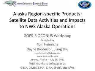
Alaska Region-specific Products: Satellite Data Activities and Impacts to NWS Alaska Operations. GOES-R OCONUS Workshop Reported by Tom Heinrichs Dayne Broderson , Jiang Zhu tom.heinrichs@alaska.edu www.gina.alaska.edu Juneau, Alaska -- July 26, 2011 With thanks to colleagues at

E N D
Alaska Region-specific Products: Satellite Data Activities and Impacts to NWS Alaska Operations GOES-R OCONUS Workshop Reported by Tom Heinrichs DayneBroderson, Jiang Zhu tom.heinrichs@alaska.edu www.gina.alaska.edu Juneau, Alaska -- July 26, 2011 With thanks to colleagues at GINA, CIMSS, STAR, CIRA, SPoRT, and NWS
Overview • Products deployed in Alaska • Product flow • Training • Feedback
3.6-meter Antenna SeaSpace X-band Ground Station MODIS on NASA Terra and Aqua 1.2-meter Antenna SeaSpace L-band Ground Station AVHRR on NOAA polar orbiters SeaWiFS
UAF-GINA + NOAA-FCDAS Barrow Station Mask • Passes per day: • NOAA AVHRR: 50 • NASA Terra/MODIS: 10 • NASA Aqua/MODIS: 10 • DoD DMSP: 20
IFR Probability MVFR Probability Cloud Type FLS Depth
March 23, 2009 12:35 UTC Examples - Redoubt Height (km) Height (kft) Maximum cloud height ~ 36,000 feet ASL Effective radius (microns) Mass loading (ton / km2)
GOES-R Proxy Data Flow • Current (for GOES-R ABI proxy algorithms) • Data captured by UAF-GINA or NESDIS-FCDAS • Sent to UW-Madison CIMSS for processing • CIMSS LDM -> GINA LDM -> Alaska NWS LDM • Alaska NWS LDM -> AWIPS • Future • Data captured by UAF-GINA or NESDIS-FCDAS • Processed by GINA at FCDAS site • GINA LDM -> Alaska NWS LDM -> AWIPS
Additional Data Flows • Data captured by UAF-GINA or NESDIS-FCDAS • GINA-processed products (e.g. natural color images) staged to GINA LDM • Level 1 MODIS data staged to ADDE server • DMSP data pulled by AAWU and put onto NWS LDM -> AWIPS • DMSP data pulled by AFWA • Natural color imagery pulled into Sea Ice Desk GIS • Natural color images viewed via web
Training Status • Volcanic ash and SO2 • 3 sessions • AAWU mandatory attendance • Completed May 2011 • Fog and cloud products • 2 sessions in July 2011
Evaluation Schedule • Preliminary: • Volcanic Ash and SO2: complete • Fog and Cloud Products: late August 2011 • Final: • October 30, 2011
Kamchatka Volcanoes – Spring 2011 • Volcanic ash products • In AWIPS in NWS Alaska WFOs and AAWU • Training completed • March 29th, 2011: eruption of KizimenVolcano • April 7th, 2011: Kizimen and Sheveluch Volcano Event • “The ash heights from Kizimen were in good agreement, not only with Tokyo VAAC who was doing the forecasting, but also with the wind analysis from 500mb winds.” Nathan Eckstein, Anchorage VAAC SOO GOES-R Ash Effective Radius Product using MODIS imagery. 0958Z 7 April 2011. Much of the ash detected shows moderate size ash particles which gives forecasters an idea of atmospheric residency times. In this particular case, ash was detectable for longer than expected given the relatively low heights.
Future Products • Volcanic ash and SO2 and Fog and Cloud product delivery in place • Delivery to NWS will continue following end of experiment • Will work with NWS users and algorithm developers to select next round of products to deliver in federal FY12
Augustine Volcano – December 12, 2005 GINA MODIS image