Download
1 / 22
220 likes | 385 Vues
Airborne and Satellite Imaging for Shallow-Water Habitats. Survey Methods for Shallow-Water Habitat Mapping in New England Dept. of Interior Holdings and Estuarine Research Reserves Workshop 30 Sep. 2009. Mark Finkbeiner. What is It?. Optical energy- UV through NIR Analog

E N D
Airborne and Satellite Imaging for Shallow-Water Habitats Survey Methods for Shallow-Water Habitat Mapping in New England Dept. of Interior Holdings and Estuarine Research Reserves Workshop 30 Sep. 2009 Mark Finkbeiner
What is It? Optical energy- UV through NIR Analog – Aerial photography Digital – Aerial multi-spectral imagery – Digital camera imagery
Aerial Sensors • DMC (Z/I Imaging) • UltraCam XP (Vexcel- Microsoft) • ADS-80 (Leica) • GeoScanner (GeoVantage) • DMSC (Ocean Imaging) • DSS (Applanix) • Others
Satellite Sensors • GeoEye-1 (GeoEye) • Orbview-2 • IKONOS (Space Imaging/GeoEye) • Quickbird (Digital Globe) • WorldView- 2 (Digital Globe) • SPOT
Advantages • Comprehensive data • Familiar data structure • Amenable to both simple and advanced analysis methods • Captures land-water interface • Broad area coverage possible • Effective in shallow waters • Effective in complex landscapes • Being collected routinely for various other applications
Disadvantages • Ineffective in deeper water • Limited by water clarity • Environmental considerations • Atmospheric conditions • Sea state • Turbidity • Sun angle • Tide
Disadvantages • Ineffective in deeper water • Limited by water clarity • Environmental considerations • Atmospheric conditions • Sea state • Turbidity • Sun angle • Tide
Disadvantages • Ineffective in deeper water • Limited by water clarity • Environmental considerations • Atmospheric conditions • Sea state • Turbidity • Sun angle • Tide
Disadvantages • Ineffective in deeper water • Limited by water clarity • Environmental considerations • Atmospheric conditions • Sea state • Turbidity • Sun angle • Tide
Disadvantages • Ineffective in deeper water • Limited by water clarity • Environmental considerations • Atmospheric conditions • Sea state • Turbidity • Sun angle • Tide
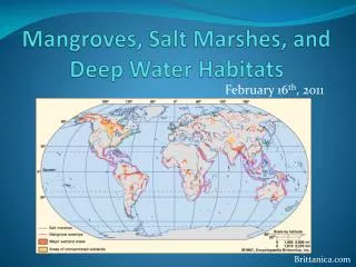
Habitats Amenable to this Technology • Coastal emergent marsh • Seagrass meadows • Intertidal and shallow- subtidal shellfish beds • Macro algae • Shoreline condition (rocky shores, beaches, artificial)
Habitats Amenable to this Technology • Coastal emergent marsh • Seagrass meadows • Intertidal and shallow- subtidal shellfish beds • Macro algae • Shoreline condition (rocky shores, beaches, artificial)
Habitats Amenable to this Technology • Coastal emergent marsh • Seagrass meadows • Intertidal and shallow- subtidal shellfish beds • Macro algae • Shoreline condition (rocky shores, beaches, artificial)
Habitats Amenable to this Technology • Coastal emergent marsh • Seagrass meadows • Intertidal and shallow- subtidal shellfish beds • Macro algae • Shoreline condition (rocky shores, beaches, artificial)
Habitats Amenable to this Technology • Coastal emergent marsh • Seagrass meadows • Intertidal and shallow- subtidal shellfish beds • Macro algae • Shoreline condition (rocky shores, beaches, artificial)
Habitats Amenable to this Technology • Coastal emergent marsh • Seagrass meadows • Intertidal and shallow- subtidal shellfish beds • Macro algae • Shoreline condition (rocky shores, beaches, artificial)
Drivers of Acquisition Cost Aerial Satellite • Level of tidal control • Ferry/Staging time • Sensor selection • Flight line complexity • Spatial resolution • Spatial accuracy • Coverage area • Licensing • Reseller • Rectification order • Vintage • Specific tasking (off- nadir, cloud restrictions, etc.) • Coverage area
Costs and Examples Aerial Image Acquisition Avg. $200 - $500/sq. mi. • South Carolina Coast $284/sq. mi. • North Carolina Coast $682/sq. mi. • Texas Coast $ Satellite Image Acquisition Avg. $300 - $500/sq. mi.* • Quickbird $72/sq. mi. min. $7,616 • IKONOS $57/sq. mi. min $5,700
Drivers of Mapping Cost • Classification detail • Mapping method • Required accuracy • Coverage area • Minimum Mapping Unit
Mapping Methods Method Time Effort Logistics • Manual digitization High High Low • Spectral clustering Med. Med. Med. • Feature analysis Low Med. High • Image segmentation Low High High Precision Method Repeatability • Manual digitization Low Low • Spectral clustering Med. Med. • Feature analysis High High • Image segmentation High High
Costs and Case Studies Mapping $200 - $500/sq. mi. • South Carolina Coast $143/sq. mi. • Long Island South Shore $674/sq. mi.* • Texas Coast $207/sq. mi.
Emerging Issues and Trends • Film is going away • Digital sensors provide additional bands, improved spatial accuracy, greater dynamic range, and a more streamlined process • Number and availability of airborne digital sensors is increasing • Satellite resolution is increasing dramatically • Satellite revisit cycles are decreasing