Download
1 / 40
400 likes | 416 Vues
Conducting a landscape analysis project in the Craig Mountain Wildlife Management Area, evaluating watershed disparities, post-wildfire vegetation changes, and ecological questions. Explore ownership, management issues, invasive species, historical legacy, and data analysis to understand the area's ecological dynamics.

E N D
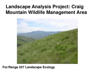
Landscape Analysis Project: Craig Mountain Wildlife Management Area For/Range 527 Landscape Ecology
Your assignment • Compare and contrast 3 watersheds. • Predict the changes in vegetation and landscape composition resulting from the 2007 wildfire • Identify and analyze an additional ecological question of your interest.
Craig Mountain Wildlife Management Area in Western Idaho Coeur d’Alene Moscow Lewiston Salmon River Snake River Boise
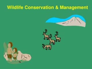
Biologically Rich • More than 200 different bird and mammal species are found here. • Riparian areas are the richest in animal and bird species. • Some streams support steelhead and red-banded trout. • Numerous plant taxa found only in Hells Canyon.
Ownership on Craig Mountain 0 5 10 Miles State Fish and Game TNC BLM Tribal land Private State Forest Service Water
Management issues • Changing focus from individual game species to multiple species and biodiversity • Sensitive species • Wildfire and the use of prescribed fire • Weeds
Invasive species • Weeds threaten ecological integrity • grasslands and open forests • invertebrate and vertebrate species dependent on those habitats • Currently, invasive species include: yellow starthistle, common crupina, leafy spurge, Scot’s thistle, cheatgrass, and medusahead
Legacy of the past • Riparian and flatter areas were once homesteaded and used for cattle grazing, pasture, crops. • In the 1930s, there were several post offices, 5 schools and up to 50 homesteads in Hells Canyon.
Data for analysis • Vegetation • Current and historical cover type (1km2) • Current cover types (30 m) • Current tree and shrub size class • Topography • Roads and streams • Soils • Ownership • Maloney Creek Fire severity • Some invasive species location data
Disturbed Grassland Foothills Grassland Exposed Rock Douglas-fir Mixed Mesic Forest Montane Parkland and Meadow Ponderosa Pine Mesic Upland Shrub Heabaceous Clearcuts Warm Mesic Shrub Broadleaf Dominated Riparian Needleleaf Dominated Riparian Graminoid or Forb Dominated Riparian Shrub Dominated Riparian Agriculture Water Craig Mountain Cover Types 0 5 10 Miles
Craig Mountain Structure Classes 0 5 10 Miles No trees or shrubs Seedling/Pole Medium tree Large tree Low shrub Medium shrub Tall shrub
Slope in the Craig Mountain case study area
Upper Deer Creek Craig Mountain Elevation and Selected Watersheds Lower Deer Creek China Garden Creek Elevation range 200 – 1600 m
Craig Mountain area before and after the Maloney Creek Fire July 27, 2000 August 28, 2000
Craig Mountain Burn Severity for the Maloney Creek fire August 2000 Estimated from Landsat 7 imagery 0 5 10 Miles No burn Underburn Mixed burn Overstory removal
No damage Moderate damage Heavy damage Map constructed from GPS and Topographic map data collected in September 2000 by Idaho Fish and Game
Poe Cabin Fire Complex July 17-September 10, 2007 23,700 ha 58,520 acres Source: http://www.inciweb.org/
Poe Cabin Fire Complex July-August 2007 Northern section Source: http://www.inciweb.org/
Considerations in the development of the team-developed analysis objective: Is it a spatial question? Is the scale of Craig Mountain WMA, or a subset of CMWMA , adequate for analysis? Are there spatial and temporal data to support the analysis? Have adequate literature been published to support the analysis?
Landsat 7 Path 42 row 28 July 27, 2000
Landsat 7 Path 42 row 28 August 28, 2000
Normalized Burn Ratio (NBR) – A Landsat TM Radiometric Measure of Burn Severity NBR = (R4 – R7) / (R4 + R7) http://nrmsc.usgs.gov/research/ndbr.htm