Download
1 / 40
440 likes | 756 Vues
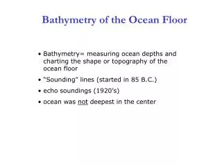
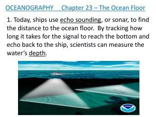
OCEANOGRAPHY Chapter 23 – The Ocean Floor. 1. Today, ships use echo sounding , or sonar, to find the distance to the ocean floor. By tracking how long it takes for the signal to reach the bottom and echo back to the ship, scientists can measure the water’s depth .

E N D
OCEANOGRAPHY Chapter 23 – The Ocean Floor 1. Today, ships use echo sounding, or sonar, to find the distance to the ocean floor. By tracking how long it takes for the signal to reach the bottom and echo back to the ship, scientists can measure the water’s depth.
2. The recorder traces a continuous profile of the area over which the ship is sailing. Such profiles help oceanographers make accurate and detailed maps of the ocean floor.
3. The intensity of the reflected sound is also measured to determine sea floor composition.
4.Scientists have used such data to pinpoint places along continental slopes that could experience landslides triggering tsunamis.
5. Scientists gather samples of the ocean floor to study its composition. They have discovered that the ocean floor consist of layer upon layer of sediment.
6. By studying these layers of sediment, scientists can learn a great deal about how Earth’s atmosphere and climate have changed over millions of years.
7. Some sediment samples are retrieved through a process called core sampling, in which a hollow instrument removes a long cylinder of material, called a core, from the ocean floor.
8. Today, satellites provide greater range and speed in the mapping process. A satellite can gather far more data more quickly than a sea going vessel.
9. Although a signal sent from a satellite cannot reach the ocean floor, it can bounce off the ocean’s surface.
10. The ocean surface varies depending upon what lies beneath it; it is slightly higher over mountains and slightly lower over undersea trenches.
11. Using a device called a radar altimeter, satellites detect variations to within centimeters.
12. The continental shelf is that part of a continent that extends from the shoreline to the continental slope. Continental shelves are very flat and their widths vary.
13. The continental slope begins at the shelf edge, where water depth begins to increase rapidly.
14. The continental rise descends gradually from the continental slope to the ocean floor. It is considered part of the ocean basin rather than part of the continent.
15. Where the oceanic plate is sliding beneath, or subducting under, the continental plate there is an active continental margin.
16. At an active continental margin, the continental slope is very steep and falls away into a deep oceanic trench.
18. Passive continental margins are not located on plate boundaries. At passive continental margins, there are no deep ocean trenches or coastal mountains.
19. Submarine Canyons, some bigger than the Grand Canyon, slice from the continental shelf clear to the ocean floor. Geologists believe that submarine canyons were formed during the Ice Age when sea level was perhaps 100 meters lower than it is now. Rivers running to the sea cut valleys to the edge of the, then exposed, continental shelf.
20. Some submarine canyons may be the result of powerful turbidity currents.
21. Turbidity Currents, triggered by earthquakes or simply gravity, are great landslides of mud.
22. A feature of the sea floor that is the flattest of all Earth’s surface areas is the abyssal plain.
23. Abyssal plains are composed of sediments, most of which came from the continents. The sediments in an abyssal plain can be over one kilometer thick.
24. Abyssal hills are small rolling hills that often occur in groups next to ocean ridges.
25. Deep-SeaTrenches are long narrow steep troughs that run parallel to active continental margins, or to volcanic island chain called island arcs. Trenches exist at subduction zones where, when plates converge, one plate sinks beneath another plate. Deep-Sea Trenches are common sites of earthquakes and volcanic activity.
26. A deep-ocean vent is a geyser that erupts underwater. When the hot vent water mixes with the cold ocean water, minerals carried from beneath the surface precipitate onto the surrounding sea floor, creating thick deposits.
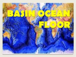
27. The most obvious feature of the ocean basin are mid-ocean ridges, great undersea mountain ranges. They form a chain over 50,000 kilometers long that wraps around the planet and crosses every ocean.
28. Mid-ocean ridges form at divergent plate boundaries where two lithospheric plates are moving apart. Magma rises between the plates and cools, forming a ridge of new sea floor.
29. Seamounts are cone-shaped mountainpeaks that rise above the deep ocean floor.
30. Volcanic in origin, seamounts seem to be related to plate boundary activity. Isolated seamount groups probably originated over hot spots.
31. The Hawaiian Islands, a famous chain of hot-spot volcanoes, were once a chain of seamounts, some of which have risen above sea level.
32. Flat topped seamounts are called guyots. Wave action removed their tops when they projected above sea level. Later, the sinking of the oceanic crust lowered the tops of the guyotsbelow sea level.
33. A coral atoll is a ring shaped coral island. An atoll forms when a coral reef develops around a volcanic island. Corals are tiny sea animals that live in shallow warm water. As the mountain sinks completely below sea level, new corals continue to form on top of the old coral, leaving behind an atoll (circular reef) with a central lagoon where the mountain top once was.
35. Terrigenoussediments come from continental rocks and minerals.
36. Biogenoussediments come from living sources; they are oozes, composed mostly of shells and skeletons from tiny marine animals.
37. Hydrogenous sediments form when chemical reactions cause minerals to crystallize from seawater. Manganese nodules are best known of the hydrogenous sediments. Manganese nodules are rich in manganese and iron oxides and contain small amounts of nickel, cobalt, copper, and other metals.
38. In the layers of sediment is a record of Earth’s history going back millions of years.
39. By studying the remains of sea creatures in the sediments, scientists can determine: a. The extent of former polar ice sheets b. The history of water temperatures c. Past behaviors of prevailing winds d. The pattern of changes in Earth’s climate
40. The sediments, unique organisms, magnetic records, and resources available on the ocean floor represent a significant portion of the Earth’s hydrosphere, biosphere, and geosphere.