Download
1 / 52
540 likes | 773 Vues
Ocean Studies Introduction to Oceanography American Meteorological Society. Chapter 6 Ocean Currents. Case in Point. Existence of the Gulf Stream, a major surface ocean current, was known as early as 1519. Bishop Resen of Copenhagen drew the first map of the Gulf Stream in 1605.

E N D
Ocean StudiesIntroduction to OceanographyAmerican Meteorological Society Chapter 6 Ocean Currents
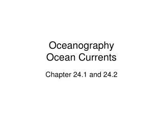
Case in Point • Existence of the Gulf Stream, a major surface ocean current, was known as early as 1519. • Bishop Resen of Copenhagen drew the first map of the Gulf Stream in 1605. • More widely known is Benjamin Franklin’s study of the Gulf Stream. • In 1769 Franklin published a chart showing the location of the Gulf Stream. • He took measurements of sea surface temperatures and developed a navigational technique based on the location of the relatively warm Gulf Stream waters.
Case in Point A B The location of the Gulf Stream (A) plotted on the 1769 Franklin-Folger map, and (B) on a much more recent infrared satellite depiction of sea-surface temperatures (SST). Shades of red indicate the highest SST.
Case in Point • In the mid 19th century, Matthew Fontaine Maury conducted the first systematic study of the ocean’s surface currents and winds. Maury • published the first charts of the North Atlantic in 1847 • estimated current direction and speed by analyzing deflections in a ship’s course caused by surface ocean currents, and • constructed a map of average surface currents over much of the ocean • Today satellite observations and data from in situ instruments have largely replaced analysis of ships’ logs in the study of ocean currents.
Ocean Currents • Driving Question: • What causes ocean waters to circulate and what are the prevailing patterns of ocean currents?
Ocean Currents • In this chapter, we examine • the characteristics of • wind-driven surface currents and • the deep ocean’s slower density-driven thermohaline circulation • the forces governing these two circulation regimes.
Ocean’s Vertical Structure • Most of the ocean is divided into three horizontal depth zones based on density: • the mixed layer, • pycnocline, and • deep layer • At high latitudes, a weak pycnocline may rise to the surface.
Ocean’s Vertical Structure A model of density stratification in the ocean.
Ocean’s Vertical Structure • Mixed Layer • Wind-driven surface currents are restricted to the ocean’s uppermost 100 m (300 ft.) or less. The strongest currents occur in the ocean’s surface layer. • Surface currents are changeable, continually responding to variations in the wind, precipitation, and heating or cooling. • Stirring of surface waters by the wind produces a well-mixed layer of uniform or nearly uniform density. For this reason, the surface ocean is known as the mixed layer.
Ocean’s Vertical Structure • Pycnocline • Situated between the mixed layer and the deep layer, the pycnocline is where water density increases rapidly with depth because of changes in temperature and/or salinity. • Where declining temperature is responsible for the increase in density with depth, the pycnocline is also a thermocline; this is the case for most of the world ocean. • On the other hand, if an increase in salinity is responsible for the increase in density with depth, the pycnocline is also a halocline.
Ocean’s Vertical Structure • Deep layer • The dark, cold deep layer below the pycnocline accounts for most of the ocean’s mass. Within the deep layer, density increases gradually with depth and water moves slowly; • In only a few locations (usually near the ocean bottom) are water movements fast enough to be considered currents.
Ocean’s Vertical Structure • Layer Stability • Following a disturbance (i.e., vertical motion) a stable system returns to its initial state or condition. • Following a disturbance a neutrally stable system neither departs from its new state nor returns to its previous state. • An unstable system shifts spontaneously towards a more stable density stratification
Ocean’s Vertical Structure • Layer Stability • The ocean’s pycnocline is very stable thus suppressing mixing between the mixed layer and deep layer; that is, the pycnocline acts as a barrier to vertical motion within the ocean. • Stability affects the vertical motion of ocean water. • Strong storm winds may temporarily disturb this stable stratification bringing colder than usual water to the surface. • Once the wind slackens, however, the original layered structure is soon restored.
Ocean in Motion: The Forces • WIND-DRIVEN CURRENTS AND EKMAN TRANSPORT • Wind blowing over the ocean exerts a frictional drag that moves surface waters which in turn would drag the layer beneath it, putting it into motion. • This propagates downward through successive ocean layers, each moving forward at a slower speed than the layer above. • If Earth did not rotate, frictional coupling between moving air and the ocean surface would push a thin layer of water in the same direction as the wind. • However, because Earth rotates, the shallow layer of surface water set in motion by the wind is deflected to the right of the wind direction in the Northern Hemisphere and to the left of the wind direction in the Southern Hemisphere.
Ocean in Motion: The Forces • WIND-DRIVEN CURRENTS AND EKMAN TRANSPORT • Using vectors to represent the direction and speed of layers of water at successive depths, we can show a highly simplified model of the current pattern caused by a steady horizontal surface wind. This model is known as the Ekman spiral • The Ekman spiral model indicates that the direction and speed of water movement changes with increasing depth. • Surface waters move at an angle of 45° to the right of the wind in the Northern Hemisphere • Each successively lower layer through a depth of about 100 to 150 m (330 to 500 ft) moves more toward the right and at a slower speed.
Ocean in Motion: The Forces The Ekman spiral describes how the horizontal wind sets surface waters into motion. • As represented by horizontal vectors, the speed and direction of water motion change with increasing depth. (B) Viewed from above in the Northern Hemisphere, the surface layer of water moves at 45° to the right of the wind. The net transport of water through the entire wind-driven column (Ekman transport) is 90° to the right of the wind.
Ocean in Motion: The Forces • WIND-DRIVEN CURRENTS AND EKMAN TRANSPORT • The net transport of water due to the coupling between the surface wind and waters is known as Ekman transport • In reality, wind-induced water movements often differ appreciably from theoretical predictions. • In the real ocean the angle between surface wind and surface water direction is closer to 15 to 20 degrees at the most, regardless of the depth of the water. The stable pycnocline inhibits the transfer of kinetic energy to deeper waters, restricting wind-driven currents to the mixed layer; • Because momentum is efficiently mixed within the mixed layer, what actually happens instead of a spiral is more like the movement of a slab.
Ocean in Motion: The Forces • GEOSTROPHIC FLOW • Ekman transport piles up surface waters in some areas of the ocean and removes surface waters from other areas, causing it to slope gradually. • This generates horizontal differences (gradients) in water pressure. • These pressure gradients, in turn, give rise to a geostrophic flow, the horizontal movement of surface water arising from a balance between the pressure gradient force and the Coriolis Effect • Geostrophic flow characterizes gyres, large-scale roughly circular surface current systems in the ocean basins.
Ocean in Motion: The Forces • GEOSTROPHIC FLOW and Gyres • Subtropical Gyres • Subtropical gyres are centered near 30 degrees latitude in each ocean • Subtropical gyres in the Northern and Southern Hemispheres are similar except that they rotate in opposite directions • The trade winds, on the equatorward flank of a subtropical high pressure system, and the westerlies, on the poleward flank of a subtropical high pressure system, drive the subtropical gyres. • Ekman transport causes waters to converge toward the central region of a subtropical gyre, producing a broad mound of water as high as 1 m (3 ft) above mean sea level.
Ocean in Motion: The Forces • GEOSTROPHIC FLOW and Gyres • Subtropical Gyres
Ocean in Motion: The Forces • GEOSTROPHIC FLOW and Gyres • Sub-polar Gyres • smaller than their subtropical counterparts; • occur at high latitudes of the Northern Hemisphere; • the Alaska gyre in the far North Pacific, and • the gyre south of Greenland in the far North Atlantic. • The counterclockwise surface winds in the Aleutian and Icelandic sub-polar low pressure systems drive the subpolar gyres. • The rotation in the sub-polar gyres is opposite that of the Northern Hemisphere subtropical gyres. • Ekman transport causes surface waters to diverge away from the central region of the sub-polar gyres.
Ocean in Motion: The Forces The long-term average pattern of wind-driven ocean-surface currents. Warm currents are red and cold currents are blue.
Wind-Driven Surface Currents • Most wind-driven surface currents transport water within a specific ocean basin. • One of the few areas of the world ocean where inter-basin transport takes place is the so-called Indonesian Through-flow. • Western boundary currents are the strongest segments of the subtropical gyres and often spawn warm-and cold-core eddies known as rings.
Wind-Driven Surface Currents • SUBTROPICAL AND SUB-POLAR GYRES • Surface currents within subtropical gyres vary considerably in strength, width, and depth. • In both the Northern and Southern Hemispheres, currents are narrowest and flow most rapidly along gyres’ western margins but are broad and slow-moving along their eastern margins.
Wind-Driven Surface Currents • SUBTROPICAL AND SUB-POLAR GYRES • In addition to the South Pacific and South Atlantic Ocean subtropical gyres, prevailing winds generate the Antarctic Circumpolar Current. • At about 60 degrees S, this current also makes up, at least in part, the southern segments of the subtropical gyres of the Atlantic, Pacific, and Indian Oceans. • The far North Atlantic and North Pacific Oceans contains sub-polar gyres, from which currents flow
Wind-Driven Surface Currents • EQUATORIAL CURRENTS • Trade winds drive both North and South Equatorial Currents westward, thus transporting warm ocean-surface waters in that direction. • Equatorial Counter Currents and Equatorial Under Currents return some warm waters eastward. • Counter Currents flow along the surface whereas Under Currents flow at greater depths below the surface.
Wind-Driven Surface Currents • EQUATORIAL CURRENTS • The trade winds of the two hemispheres converge along a narrow well-defined east-west belt located near the equator known as the intertropical convergence zone (ITCZ). • For mariners, this region of the tropical ocean is known as the doldrums due to light and variable winds • Seasonally, the ITCZ moves with the sun, shifting northward during the Northern Hemisphere spring and southward during the Northern Hemisphere autumn, but generally remaining north of the equator
Wind-Driven Surface Currents • BOUNDARY CURRENTS • Why are the western boundary currents stronger than the eastern boundary currents? • Why are the subtropical gyres not centered in the ocean basin but shifted westward? • To explain, we must invoke the principle of the conservation of angular momentum. • The conservation of angular momentum in an ocean gyre involves three factors that must balance for the current to flow in a curved path. • surface winds, • the Coriolis Effect, and • frictional drag of the coast
Wind-Driven Surface Currents Surface ocean currents are faster, narrower, and deeper on the western side of an ocean basin. These are known as western boundary currents. Note that the vertical scale is greatly exaggerated.
Wind-Driven Surface Currents • BOUNDARY CURRENTS • Near the equator, surface winds produce little horizontal spinning or rotation of the ocean water occurs because the Coriolis Effect is almost zero. • Along the western side of the ocean basin this non-rotating ocean water is transported poleward. In traveling poleward, the Coriolis Effect increases, shifting motion to the right in the Northern Hemisphere (and to the left in the Southern Hemisphere.) • In the North Atlantic, once this water reaches the northwest quadrant of the ocean basin, it then flows eastward as part of the North Atlantic Current in balance with its Coriolis induced clockwise spin.
Wind-Driven Surface Currents • BOUNDARY CURRENTS • The northward flowing current becomes faster, deeper, and flows closer to the Eastern Seaboard. • Upon entering the northeast quadrant of the North Atlantic, the ocean water turns toward the south on the east side of the ocean basin. • As the water flows from high latitudes toward the equator the Coriolis effect weakens, and to remain in balance, the eastern boundary currents remain relatively wide, slow, shallow, and away from the coast.
Wind-Driven Surface Currents • OCEAN RINGS • A ring forms when a meander in a boundary current (or the Antarctic Circumpolar Current) becomes a loop that pinches off (separates) from the main current and moves independently as a large turbulent rotating warm-core or cold-core eddy. • Rings extend to some depth in the ocean and should be thought of as cylindrical pools of water rather than simply surface features.
Wind-Driven Surface Currents • OCEAN RINGS • Rings form on either side of the Gulf Stream. • On the north side, rings are typically 100 to 200 km (60 to 120 mi) across and enclose warm waters from the Sargasso Sea; hence, they are called warm-core rings. • Viewed from above, these warm-core rings rotate in a clockwise direction. • Because of the strong contrast in sea-surface temperatures, they are readily detected on infrared satellite images. • Warm-core rings are also readily distinguished from the surrounding surface waters by their relatively low levels of biological production
Wind-Driven Surface Currents In this NASA satellite image of ocean biological production, a prominent warm-core ring shows up as a nearly circular blue/violet region in ocean waters east of Delaware. Relatively low levels of phytoplankton pigment are indicated by blue/violet and relatively high levels are indicated by orange/red. White areas are clouds.
Wind-Driven Surface Currents • OCEAN RINGS • Cold-core Rings • Rings that spin off the south side of the Gulf Stream entrain relatively cold and productive coastal waters and are called cold-core rings. • These rings have diameters of about 300 km (185 mi). • They rotate in a counterclockwise direction. • Their originally cool surface waters are warmed by absorption of solar radiation making them almost indistinguishable thermally from surrounding surface waters. However, cold water persists below the surface. • Cold-core rings usually contain more nutrients and marine organisms than the biologically barren waters that surround them.
Wind-Driven Surface Currents • OCEAN RINGS • North Atlantic rings move slowly (typically 5 to 6 km or 3 to 4 mi per day), drifting southwestward in the weaker currents on either side of the northeast flowing Gulf Stream. • The proximity of the Gulf Stream to the coast limits the southward movement of warm-core rings and they typically get reabsorbed into the Gulf Stream. • Cold-core rings are not as restricted in their movements as warm-core rings; on average, individual cold-core rings last for about 18 months.
Wind-Driven Surface Currents • UPWELLING AND DOWNWELLING • Coastal upwelling occurs where Ekman transport moves surface waters away from the coast; surface waters are replaced by water that wells up from below.
Wind-Driven Surface Currents • UPWELLING AND DOWNWELLING • Where Ekman transport moves surface waters toward the coast, the water piles up and sinks in the process known as coastal downwelling.
Wind-Driven Surface Currents • UPWELLING AND DOWNWELLING • Upwelling is most common along the west coasts of continents (eastern sides of ocean basins where winds cause Ekman transport of surface water away from the shore. • Upwelling and downwelling also occur in the open ocean where winds cause surface waters to diverge (move away) from a region (causing upwelling) or to converge toward some region (causing downwelling). • equatorial upwelling occurs where westward-flowing, wind-driven surface currents near the equator turn poleward moving surface waters away from the equator.
Wind-Driven Surface Currents An infrared satellite image shows the relatively cold upwelling waters along the coast of central and northern California in response to the Ekman transport caused by winds blowing from the north. According to the color scale, the lowest sea surface temperatures are plotted as blue and purple.
Wind-Driven Surface Currents Equatorial upwelling (A) In this plan view of the ocean from 5 degrees S to 5 degrees N, the trade winds of the two hemispheres are shown to converge near the equator. The consequent Ekman transport away from the equator gives rise to upwelling as shown in (B) a vertical cross section from 5 degrees S to 5 degrees N.
Wind-Driven Surface Currents • UPWELLING AND DOWNWELLING • Upwelling and downwelling influence sea-surface temperature and biological productivity. • Upwelling waters originate at considerable depth and are usually colder than the surface waters they replace. • Coastal upwelling transports waters rich in dissolved nutrients from the ocean depths into the photic zone where sunlight penetrating the water supports the growth of phytoplankton populations. • Downwelling reduces biological productivity and transports heat, dissolved materials, and surface waters rich in dissolved oxygen to greater depths. • Alternate weakening and strengthening of upwelling off the coast of Ecuador and Peru are associated with El Niño and La Niña episodes in the tropical Pacific.
Wind-Driven Surface Currents • Probing the ocean depths to determine the vertical structure and circulation of the ocean has been much more challenging than investigating surface waters. • Ocean scientists use the term cast for measurements made at various depths in the ocean. • New promising ocean sensing technologies include submersible, instrumented floats that obtain vertical profiles of temperature, pressure (a measure of depth), and conductivity (a measure of salinity.) • Typically, a float is programmed for a 10-day cycle • It sinks to a prescribed depth of 1000 m (3300 ft), drifts with the current for 9 days before sinking to a maximum depth of 2000 m (6600 ft), and then returns to the surface, monitoring ocean water properties along the way. At the surface, the float relays its collected data via satellite to computer databases.
Monitoring the Ocean Depths An Argo float obtains continuous profiles of ocean temperature and salinity to a maximum depth of about 2000 m. The instrument surfaces and sends data to a satellite for downloading.
Monitoring the Ocean Depths This is a sample plot of float-derived temperature and salinity profiles obtained at a location in the eastern North Pacific, west of Northern California, on 1 February 2008.
Thermohaline Circulation • Deep-ocean circulation driven by variations in density is termed thermohaline circulation or meridional overturning circulation (MOC). • The MOC consists of two western boundary currents • the warm Gulf Stream flowing northward and • the Deep Western Boundary Current flowing southward. • The Gulf Stream is a heat source for the atmosphere until in the subpolar North Atlantic some surface waters become sufficiently cold and dense to sink to the ocean bottom. • This cold deep water then flows southward along the continental slope of the eastern U.S. as the Deep Western Boundary Current.
Thermohaline Circulation • The thermohaline circulation (or the meridional overturning circulation) is the dominant type of flow in the deep ocean. • Although deep-ocean currents are relatively weak, the volume of deep water is much greater than the volume of surface waters so that the magnitude of water transport is about the same. • The deep circulation, which varies from years to millennia, contributes to poleward heat transport and helps modulate climate change.
Thermohaline Circulation • FORMATION OF DEEP WATER • Density gradients in the deep ocean are established by dense waters sinking in a few select locations. • The primary mechanism of deep water formation in the Northern Hemisphere is open ocean convection. • Deep water forms in late winter when surface water, cooled by cold winds, has reached its lowest temperature and hence its greatest density. • The density of this surface water becomes greater than that of all the water beneath it, creating an unstable water column and driving overturning.
Thermohaline Circulation • WATER MASSES • Water properties such as temperature and salinity are altered primarily by interaction with the atmosphere at the surface of the ocean. • Thus, after sinking, the characteristic temperature and salinity of the water is largely conserved. • A large, homogeneous volume of water having a characteristic range of temperature and salinity is known as a water mass. • Water masses are typically identified based on their source region at the ocean surface. • Another principal type of water mass in the thermohaline circulation is intermediate water which rests above the deep waters but below the wind-driven circulation.