Download

1 / 26
260 likes | 361 Vues
Compare simulation results for different land-use scenarios, assessing management effectiveness. Altering recharge rates and practices for corn, urban, and brome grass areas. Analyze well depths and locations impact on groundwater flow.

E N D
Schematic Cross-section Bedrock
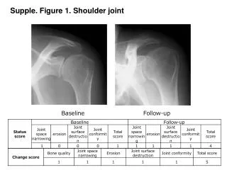
Reality Check SWL/Data778-920 ft Model782-922ft Modeling based on GWIM data matches surprisingly well with the SWL w/o calibration
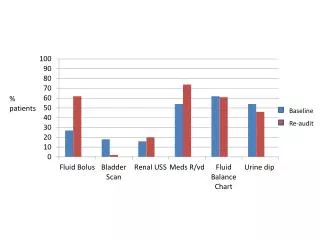
Flow ≈ 0.02 cfs Flow ≈ .04 cfs 0.42, 0.41 0.00, 0.05 Flow ≈ 6.5 cfs Flow ≈ 0.56 cfs 6.61, 6.38 0.07, 0.08 0.45, 0.07 1.34, 1.45 0.68, 0.73 Flow ≈ 9.4 cfs 13.82, 14.85 Flow ≈ 3.9 cfs 3.33, 2.55 21, 29 Total Flow ≈ 23.75 cfs Comparison with Observed Baseflow
Changes in Land-use/Land Management Practices • Corn Brome grass • Rate of recharge 12 in/yr → 16.5 in/yr • Corn Medium Density Residential • Rate of recharge 12 in/yr → 8.3 in/yr • Corn Corn-winter Wheat • Rate of recharge 12 in/yr → 11.5 in/yr
Simulation Results Corn Urban Use
Simulation Results Corn Brome grass
Sub-model Maps Brome grass Corn
Sub-model Maps Urban use Corn
Put in a high capacity well • Well Location: Upstream vs. Downstream • Well Depth: Shallow vs. Deep
Shallow well Upstream Downstream
Shallow Wells Before Wells Upstream Downstream
Shallow Wells Before Wells Upstream Downstream
Deep well Upstream Downstream
Deep Well Before Wells Upstream Downstream
Deep Well Before Wells Upstream Downstream