Download
1 / 9
100 likes | 274 Vues
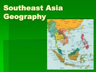
Geography of Southeast Asia. The Himalayas. The Himalayan Mountains on South and Eastern Asia are the largest in the world. Mount Everest is more that 5 miles high and is the tallest mountain peak on earth. Himalayas stretch 1,550 miles across Pakistan, India, Nepal, Bhutan, and China.

E N D
The Himalayas • The Himalayan Mountains on South and Eastern Asia are the largest in the world. Mount Everest is more that 5 miles high and is the tallest mountain peak on earth. • Himalayas stretch 1,550 miles across Pakistan, India, Nepal, Bhutan, and China. • Animals found in the region are snow leopards, black bears, and marmots. • Sherpa’s are a group of people who live in the region and are primarily herders and farmers.
Deserts • Gobi – about 1000 miles long and between 3 & 6 hundred miles wide. It stretches across parts of China and Mongolia. • Most of the desert is bare rock rather than sand. • Harsh winters if -40 degrees, summers around 113 degrees • Taklimakan – sandy desert located in China – hazardous to cross • Extreme cold at night (-4) and hot during the day
Korean Peninsula • A Peninsula is a body of land that extends out into a body of water. Surrounded on 3 sides by water. • The Korean peninsula shares a mainland border with China. • The peninsula is divided between North and South Korea and stretches about 684 miles. • It is very mountainous
Major Rivers • The Mekong – one of the longest rivers in Southern & Eastern Asia @ 2,700 miles long. • It travels through China, Cambodia, Laos, Thailand and Vietnam then goes into the South China Sea. • Ganges – begins in the Himalayas and is about 1,560 miles long, it ends in the Bay of Bengal after going thru Bangladesh
Major Rivers • Indus – is the longest river in Pakistan @ 1,900 miles and empties into the Arabian Sea. This is Pakistan main water supply. • Yangtze – China’s longest river at 3,500 miles. • Huang He (Yellow) – because of the color of the silt that covers the ground along the shores. Huang He begins in Tibet and runs into the Yellow Sea.
Oceans and Seas • Indian Ocean – 1/5 of all ocean water, it stretches 6,200 miles from the Southern tip of Africa to Australia and Asia in the North to Antarctica in the south. It connects Asia to Europe and Africa. • Bay of Bengal – northeast of the Indian Ocean provides ports for shipping
Oceans and Seas • Yellow Sea –lies between China and the Korean Peninsula – it name comes from the silt from China’s river • Sea of Japan-the coasts of Japan, Russia and Korea are along this sea. • South China Sea-provides many people of the region with seafood and is a trade route
TOTD • 1. Which river runs south from Tibet to Vietnam and the South China Sea? • A. Indus b. Mekong c. Yangtze D. Ganges • 2. Which country is a peninsula? • A. Japan b. Korea c. Vietnam d. China • 3. Which river flows through Bangladesh to the Bay of Bengal? • a. Indus b. Ganges c. Mekong d. Huang He • 4. Which desert spans both Mongolia and China? • A. Taklimakan b. Sahara c. Gobi d. Kalahara