Download
1 / 83
830 likes | 1.28k Vues
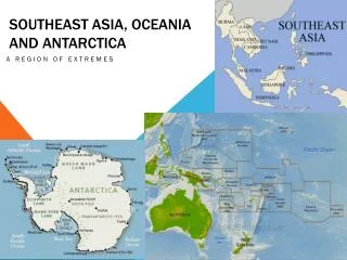
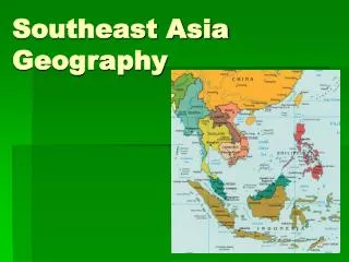
Geography of Southeast Asia AND Oceania. Southeast Asia. Southeast Asia: Mainland and Islands . Mainland Southeast Asia lies on two peninsulas - rectangular Indochinese Peninsula is south of China - Malay Peninsula is 700-mile strip south from mainland .

E N D
Southeast Asia: Mainland and Islands • Mainland Southeast Asia lies on two peninsulas - rectangular Indochinese Peninsula is south of China - Malay Peninsula is 700-mile strip south from mainland
Southeast Asia: Mainland and Islands • Malay Peninsula bridges mainland and island archipelagoes - archipelago—set of closely grouped islands, often in a curved arc - Malay Archipelago includes the Philippines & Indonesian islands
Southeast Asia: Mainland and Islands • Mountains and Volcanoes - Island mountains are volcanic in origin, part of Pacific Ring of Fire - volcanic eruptions, earthquakes are common in region
Southeast Asia: Mainland and Islands • Rivers - Several large mainland rivers run south through mountain valleys - spread out into fertile deltas near coast • Natural Resources - Volcanic activity, flooding rivers create nutrient-rich, fertile soil • Rivers, seas provide fish; some areas have petroleum, tin, gems
Southeast Asia: Mainland and Islands • Climate - Tropical wet climate in coastal Myanmar, Thailand, Vietnam, Oceania - also in most of Malaysia, Indonesia, Philippines - High temperatures—annual average of 80 degrees in Southeast Asia - Parts of Southeast Asia get 100, even 200 inches of rain annually
Southeast Asia: Mainland and Isla • Tropical wet and dry climate found in parts of Myanmar, Thailand, Laos, Cambodia, Vietnam - weather is shaped by monsoons - Monsoon areas often have disastrous weather - typhoons can occur in region during the wet season
U.S. involvement in Southeast Asia • 1957 – 1975 - U.S. became involved in Vietnam War - tried to stop Communist control of South Vietnam • 1973 - U.S. left & South Vietnam surrendered in 1975 • Vietnam, Cambodia, Laos became Communist
An Uneven Economy • Agriculture is region’s main income source - rice is chief food crop -Myanmar is heavily forested & produces teak wood • Growth of cities is linked to industrialization—growth of industry
An Uneven Economy • Scarcity of land—in Philippines 3% of landowners hold 25% of land • 60% of rural families don’t have enough land toearn a living farming • Population growth—as populations grow, land shortages increase - farmers divide land among heirs—plots becometoo small • Southeast Asian cities have trouble dealing with numerous immigrants
An Uneven Economy • Housing availability can’t keep pace - many immigrants live in slums • Traffic increases due to workers driving, trucks hauling goods - creates more pollution, particulates - 5,000 people a year die from breathing polluted air in Bangkok & Thailand
An Uneven Economy • People are afraid that the income gap between the rich & poor will cause social unrest & increased crime rates
Southeast Asia Review Questions What is an archipelago? What was the United States attempting to prevent in the Vietnam War? What are many people afraid that income gap in Southeast Asia will cause? How do cities suffer in times of rapid urbanization? What type of landform is abundant in the Ring of Fire?
Oceania • No one knows how many islands there are in the Pacific - some estimate there are more than 20,000 - hard to count because islands vanish and new ones appear • As a group, the Pacific Islands are called Oceania - includes New Zealand, Australia (a continent, not an island)
Oceania • Three geographic, cultural regions: -Micronesia—“tiny islands” - Melanesia—“black islands” -Polynesia—“many islands” • Volcanoescreate high islands, coral reefs make up low islands - most islands are small; total land area is smaller than Alaska
Island Life • Traditional Life- fishing & farming economies (Subsistence Activities) - taro - starchy root that makes poi—a major crop - fishing villages on coasts & farming, hunting, & gathering inland
Island Life • Few cities, but they’re growing - people move for education, jobs - fast growth means shantytowns, bad sanitation - urban dwellers giving up traditional ways • Modern communication links island groups, connects Oceania to world
Nuclear Tests • 1940s - Nuclear arms race between U.S., USSR began • U.S. conducted 66 nuclear bomb tests on Bikini, & Enewetak atolls - atoll - ringlike coral island, or islands, surrounding a lagoon
Nuclear Tests • “Bravo” hydrogen bomb test vaporized several islands - radiation contamination injured or sickened many islanders
Nuclear Tests • 1948 - Bikini Islanders moved to the island of Kili - conditions there don’t allow them to fish or grow enough food • Late 1960s - U.S. declared Bikini safe & some islanders return • 1978 - doctors found dangerous radiation levels in islanders & islanders left again • 1988 - Cleanup of Bikini Atoll began - still unknown when Bikini will be suitable for humans again
Oceania What name are the Pacific Islands known as Name the three regions of Oceania? What do most people in Oceania do for a living? What does Micronesia mean? What does Melanesia mean? What does Polynesia mean? How were the high island formed? How were the low islands formed? Why were the Bikini Atoll inhabitants forced to move?
New Zealand • New Zealand has two main islands, North Island and South Island • Southern Alps—300-mile mountain range down center of South Island - 16 peaks over 10,000 feet; over 360 glaciers • North Island has hilly ranges, volcanic plateau - fertile farmland; forests for lumber; natural harbors • Few mineral resources, but dams generate electricity