Southeast Integrated Climate Assessment
140 likes | 274 Vues
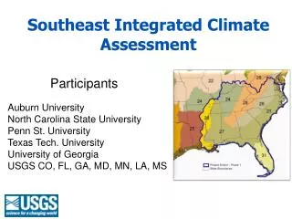
Southeast Integrated Climate Assessment. Participants. Auburn University North Carolina State University Penn St. University Texas Tech. University University of Georgia USGS CO, FL, GA, MD, MN, LA, MS. Southeast Integrated Climate Assessment.

Southeast Integrated Climate Assessment
E N D
Presentation Transcript
Southeast Integrated Climate Assessment Participants Auburn University North Carolina State University Penn St. University Texas Tech. University University of Georgia USGS CO, FL, GA, MD, MN, LA, MS
Southeast Integrated Climate Assessment • Regionally downscaled probabilistic climate change projections • Integrated Coastal Assessment – Southeastern Pilot • Climate change and its impacts on bird habitats • Designing sustainable landscapes: climate and land use change projected impacts on priorities species habitats • Patch and range dynamics of North American avian species in response to land use patterns and climatic change • Multi-resolution assessment of potential climate change effects on biological resources: Aquatic and hydrologic dynamics • Optimal conservation strategies to cope with climate change
Historic LULC Trends (Grand) Downscaled Climate Change Projections (Hayhoe) Avian Range Dynamics (Collazo, Nichols) Optimal Conservation Strategies (Grand et al.) Designing Sustainable Landscapes (McKerrow) Probabilistic Climate Change Projections (Haran) Watershed Model (Hay) ACF Aquatics (Peterson) Coastal Sea Level Rise (Burkett)
Southeast Integrated Climate Assessment • Regionally downscaled probabilistic climate change projections • Development and Dissemination of High-Resolution National Climate Change Dataset • Integrated Coastal Assessment – Southeastern Pilot • develop a Bayesian statistical framework for predicting coastal erosion and inundation under a range of sea level rise scenarios and considering the combined effects of geologic constraints and other driving forces, • assess the potential impacts of sea level rise on coastal ecosystems and related wildlife resources, and • develop visualization products that will help natural resource managers anticipate sea level rise and adapt to the changes that are projected over the coming decades.
BHNU Route Occupancy + Spatial Context • Optimal Habitat [+] • loblolly-shortleaf & longleaf-slash pine associations • Size*Distance [-] • Latitude 32°- 34° [+] 4.73 km 1.47 km • no. of patches (~20) [+] • Median Distance - 2.5 km • Median Patch Size - 14 ha
Habitat Dynamics…and climate… 1973 Landcover 1980 Landcover 1990 Landcover 2000 Landcover 1973 Psi 1980 Psi 1990 Psi 2000 Occupancy conditioned (given) on what the habitat does
Optimal conservation strategies for dynamic landscapes Incorporating climate change and urban growth in conservation planning James B. Grand, USGSAlabama Cooperative Fish and Wildlife Research Unit
When to act? Adapted from: Lawler, J.J., 2009
Adaptation strategies • Resistance – ability to remain unchanged • Resilience – ability to recover from perturbation • Change – help systems move from one state to another Lawler, J.J., 2009. Climate Change Adaptation Strategies for Resource Management and Conservation Planning. The year in ecology and conservation biology, 2009. New York Acad. Sci. 1162:79-98.
Restoring habitat & system dynamics • Current restoration strategies: • Return system to historic conditions • Return community to historic assemblage • Climate-forced paradigm shifts? • Restore ecosystem processes • Focus on abiotic aspects • Allow species assemblages to fluctuate
Competing hypotheses & uncertainty • Climate models? • Which one(s)? • Projections versus predictions • Habitat responses - driving influences • Fire frequency • Insect outbreaks • Drought • Temperature • Invasive species • Wildlife responses? Matthews et al. Climate Change Bird Atlas. http://nrs.fs.fed.us/atlas/bird/index.html Image screated by Robert A. Rohde / Global Warming Art
Structured decision making Problem Decision Objectives Optimization & Tradeoffs Alternatives Consequences
Optimization & adaptive framework Strategic Habitat Conservation Adaptive Management
Scope & timeline • Workshops • Project – blue line • Organized roughly by ecoregions • Completed by mid-2010 • Decision model • Framework 2012 • Fully parameterized 2015